MESONET TICKER ... MESONET TICKER ... MESONET TICKER ... MESONET TICKER ...
November 7, 2022 November 7, 2022 November 7, 2022 November 7, 2022
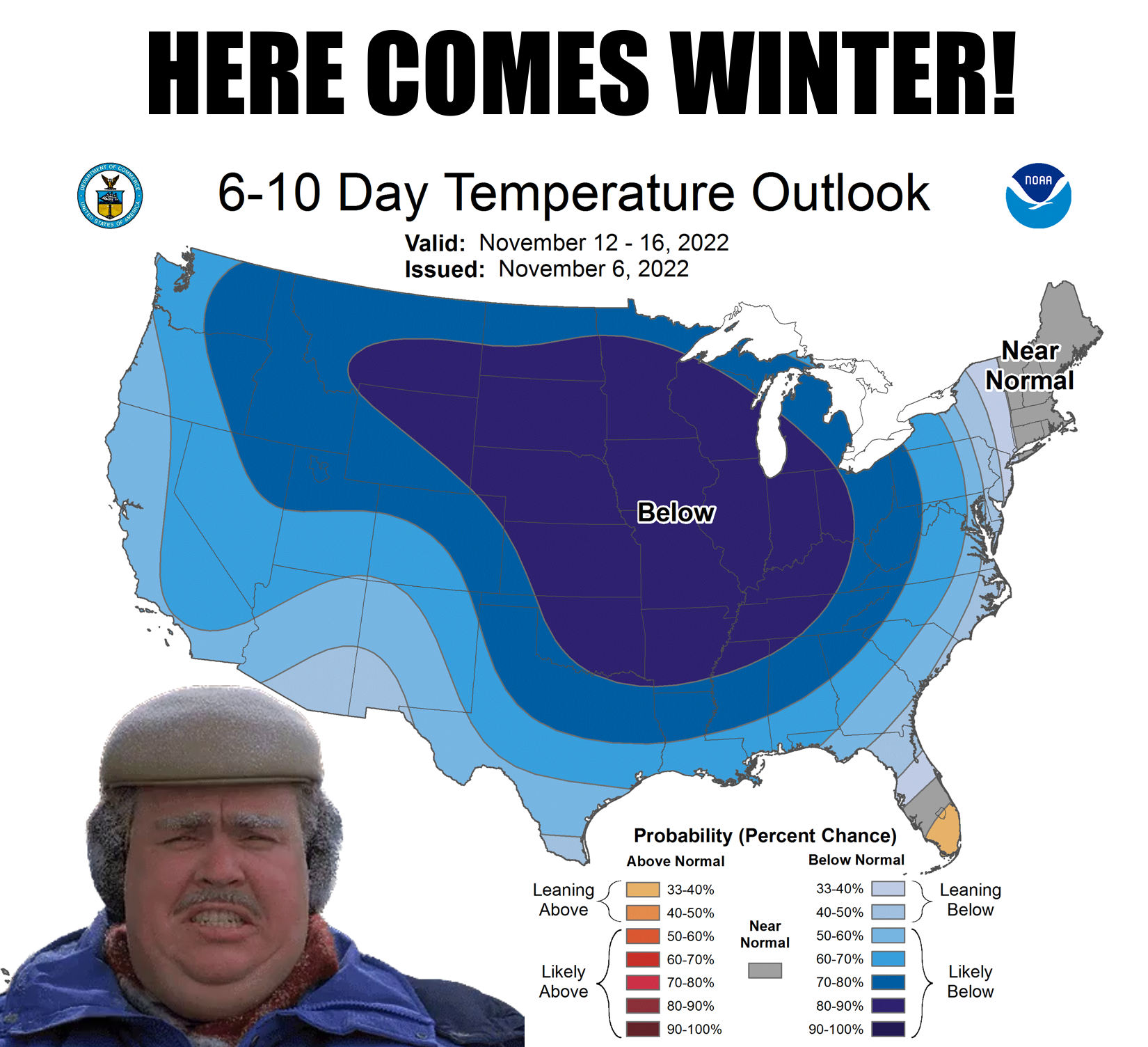
Bring on the cold?
https://ticker.mesonet.org/archive/20221107/nov12-16-temp-outlook.png
Wait, bring on the cold? Really? Yes, this is still Gary McManus, follicularly-
challenged Master of all Time and Space* (*powers limited to eating Pop-Tarts
with nothing to drink...try it, you'll see it's pretty tough)? Well, yeah...the
way I see it, nothing too bad happens when it's 42 degrees outside. Well, other
than having to wear extra clothes. Layers (shudder), even.
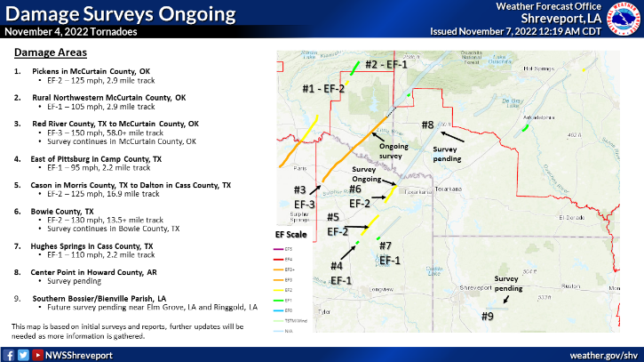
But isn't the cold weather a darned sight better than what we saw Friday, when
the threats of high-end severe weather came to fruition and dropped up to 3
twisters on extreme SE OK (and over a dozen across the ArkLaTex)?
https://ticker.mesonet.org/archive/20221107/nws-shreve-tornado-surveys.png
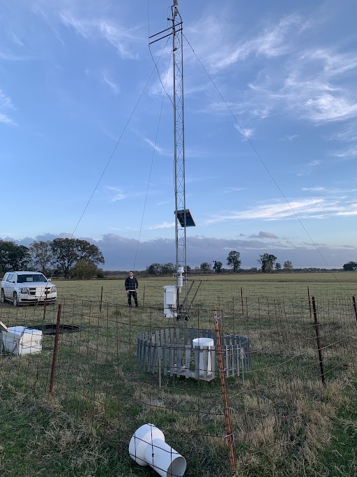
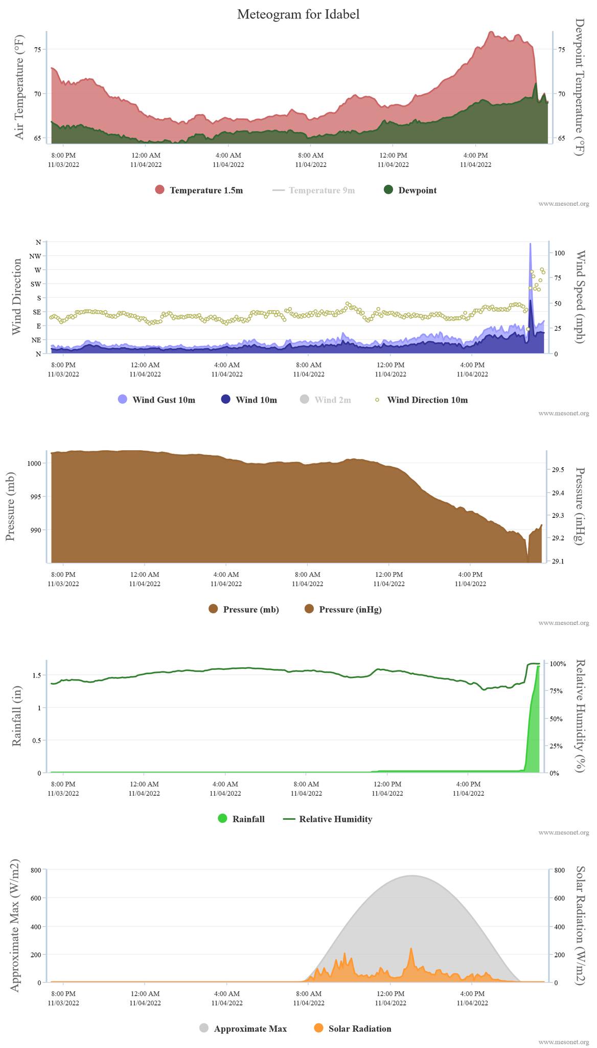
The biggie for us, of course, was the strong tornado that hit Idabel, injuring
30 and killing 1 person. The tornado traveled extremely close to our Idabel
Mesonet site, becoming the fifth Mesonet site directly impacted by a tornado,
joining El Reno (5/24/2011), Tipton (11/7/2011), Fort Cobb (11/7/2011), and
Inola (8/9/2018). The 108 mph wind gust would also be the highest since the 151
mph gust during the May 24, 2011, El Reno strike by an EF-5 twister.
https://ticker.mesonet.org/archive/20221107/idabel-site.jpg
https://ticker.mesonet.org/archive/20221107/idabel-tornado-hit.jpg
https://ticker.mesonet.org/archive/20221107/idabel-meteogram.jpg
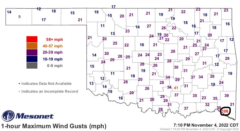
Apparently the gust was from Rear Flank Downdraft according to NWS Shreveport
meteorologists surveying the damage path:
"AFTER CROSSING THE RED RIVER AND ENTERING MCCURTAIN COUNTY,
OKLAHOMA, THE TORNADO PRODUCED AT LEAST EF-2 DAMAGE, RIPPING THE
ROOFS OFF SEVERAL SINGLE FAMILY HOMES. BEFORE REACHING IDABEL,
THE TORNADO MISSED THE OKLAHOMA MESONET IDABEL OBSERVING PLATFORM
BY APPROXIMATELY 150 YARDS. AT THE PLATFORM, A MEASURED GUST OF
108 MPH WAS RECORDED BY THE 10M ANEMOMETER AND BASED ON THE
DAMAGE PATTERN OF THE GRASS IN THE AREA, IT WAS DETERMINED THAT
THIS GUST WAS FROM THE REAR FLANK DOWNDRAFT OF THE SUPERCELL
THUNDERSTORM."
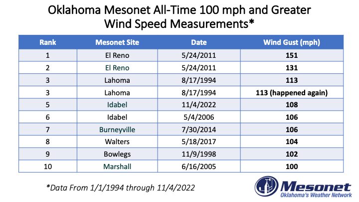
The 108 mph gust ranks as the fifth highest wind gust since Mesonet wind
measurements began in 1994.
https://ticker.mesonet.org/archive/20221107/OK-mesonet-alltime-gusts.jpg
#s 1 and 2 came from the EF-5 that hit El Reno, but the two Lahoma wind gusts
were from straight-ling winds. At any rate, being on this list is not an honor.
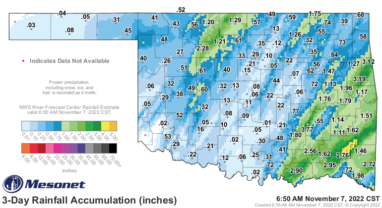
We did get some beneficial rainfall, and as we know being Okies, you often have
to take the good (moisture) with the bad (severe weather) around these parts.
https://ticker.mesonet.org/archive/20221107/3day-rain-totals.png
So as we go through our next few days of deliciously warm weather, we await
our next cold front on Thursday which will usher in nearly a week of below
normal temperatures, which at times will feel like December, which is just a
few weeks away anyway. Might as well visit it early.
https://ticker.mesonet.org/archive/20221107/nws-norman-7day-temps.png
Expect lots of highs in the 40s and 50s and lows in the 20s and 30s.
https://ticker.mesonet.org/archive/20221107/nws-norman-7day-temps.png
https://ticker.mesonet.org/archive/20221107/saturday-highs.png
https://ticker.mesonet.org/archive/20221107/sunday-lows.png
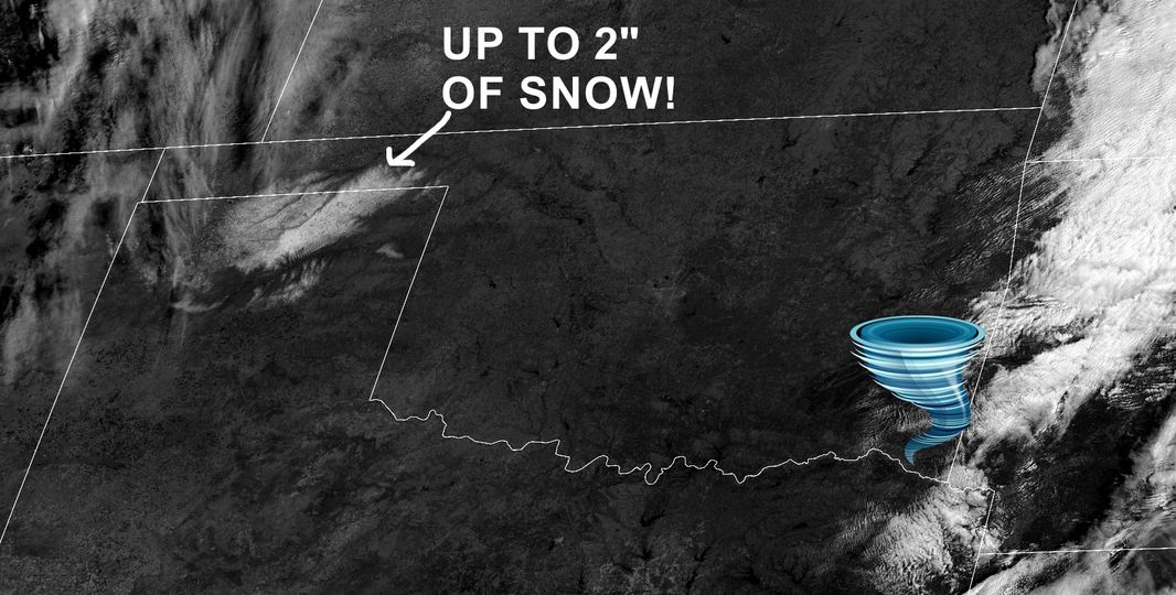
Snow? Yeah, I heard you thinking that (okay, my ONE other power besides the
Pop-Tarts deal) maybe we will see our first snowfall in the state during this
period. Well, don't bother...that first snow already happened overnight Friday
in the Panhandle.
https://ticker.mesonet.org/archive/20221107/weekend-snow.jpg
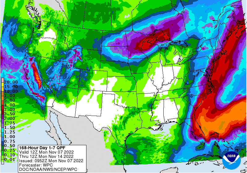
The chances for moisture we DO have over the next few days are expected to be
on the light side.
https://ticker.mesonet.org/archive/20221107/7day-rain-forecast.gif
So break out that winter coat...dust off the sweaters...then go buy something to
store your sweaters in--they shouldn't be getting dusty.
Gary McManus
State Climatologist
Oklahoma Mesonet
Oklahoma Climatological Survey
gmcmanus@Mesonet.org
==================================================
The OCS/Mesonet Ticker
https://ticker.mesonet.org/
To subscribe or unsubscribe from the Ticker
or for questions about the Ticker or its content
Phone or Email the Ticker Manager at OCS
Phone: 405-325-2253 Email: ticker@mesonet.org
---------------------------------------------------
-C- Copyright 2024 Oklahoma Climatological Survey
===================================================
|


 Tweet
Tweet