MESONET TICKER ... MESONET TICKER ... MESONET TICKER ... MESONET TICKER ...
October 6, 2022 October 6, 2022 October 6, 2022 October 6, 2022
Dry and Drier?
https://ticker.mesonet.org/archive/20221006/oct11-15-precip-outlook.png
Not much time to Tick today, I'm attempting to buy the Texas Panhandle...or as we
call it: "A good place to put memes."
Look, I don't know if we're going to get drought-quenching rains from the set of
storm systems and fronts forecast (say "forecasted"...I dare ya) to move through
our area over the next week or two. All I know is. Yeah, I meant to put the period
there. Let's try again. What I think I know is that droughts work in mysterious
ways, and they have ways of persisting that would make toenail fungus green (UGH!)
with envy. HECK NO I don't have personal knowledge, but the internet seems to
think so because I can't open a browser without having a pic of a nasty big toe
on it.
Speaking of nasty:
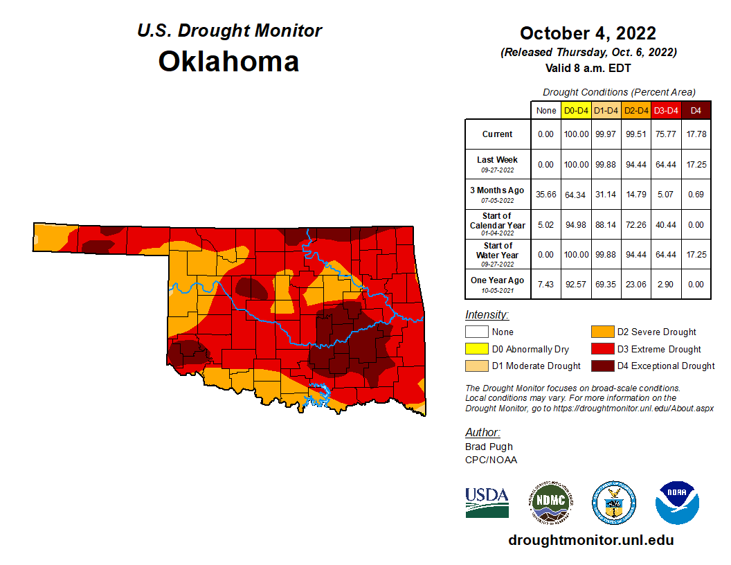
https://ticker.mesonet.org/archive/20221006/20221004_ok_trd.png
We now have 76% of the state in that Extreme/Exceptional (D3/D4) drought on the
Drought Monitor, again this is territory not seen in the state since early
February 2013. While that was year three of our horrible 2010-15 drought
period, what I remember from that time was empty lakes, water emergencies,
and runaway wildfires. While we're not in emergency territory yet with our
lakes, they ain't good. And we are going to have a horrible wildfire season
without help. We might anyway.
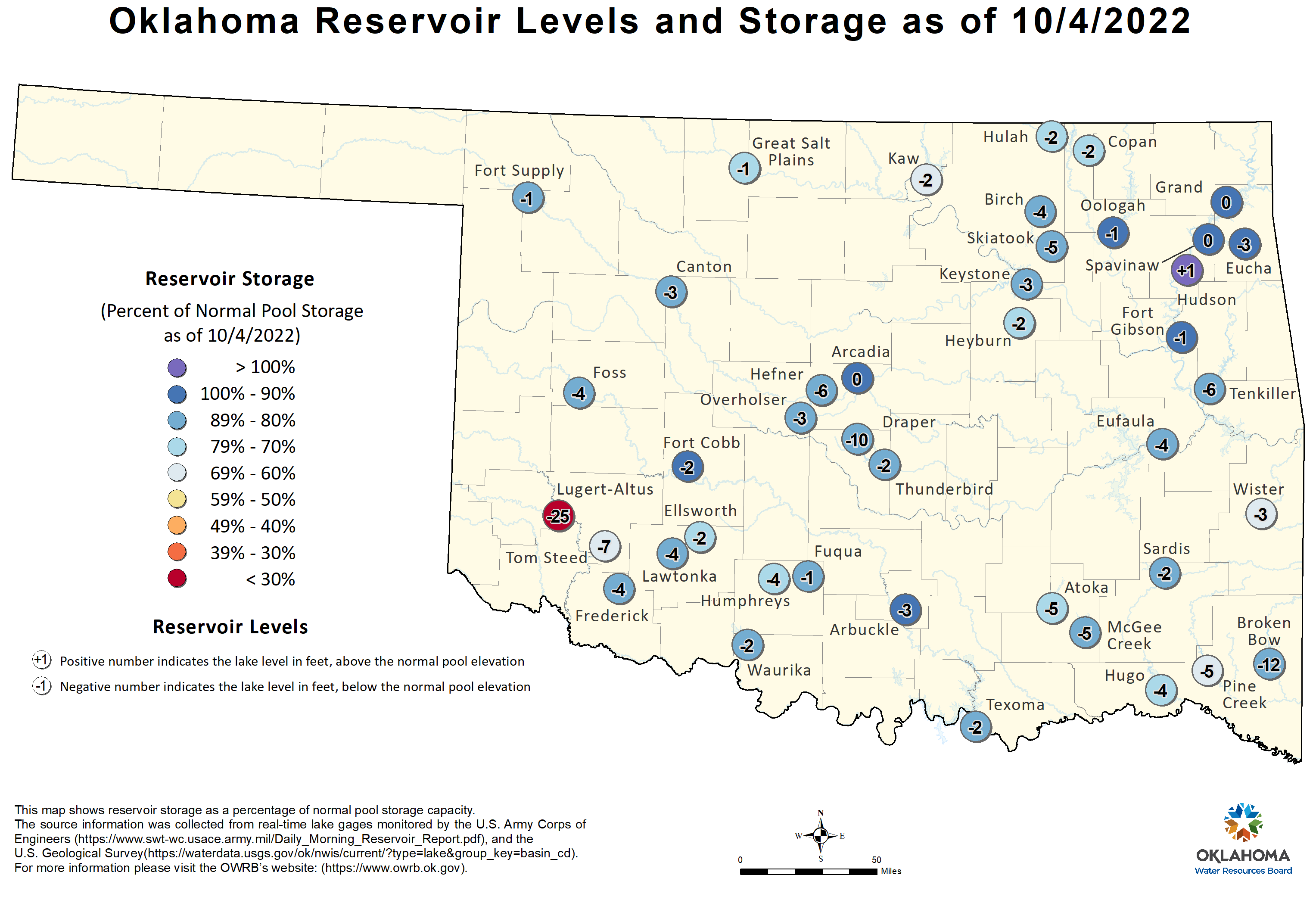
https://ticker.mesonet.org/archive/20221006/ok-lake-levels.png
https://ticker.mesonet.org/archive/20221006/KBDI.png
https://ticker.mesonet.org/archive/20221006/16inch-PAW-fire.danger.png
I've gone over our record-setting dry weather the last couple of Tickers, for
both the last 30 days (and counting) and since the flash drought began on June
11, so I won't bore you with that information again.
What did you say? I heard that you know!
We can talk about our rain forecast, and possible wet weather from now and again
off and on through the next week. The forecast for far western OK and the
Panhandle is looking the best through the next 7 days.
https://ticker.mesonet.org/archive/20221006/7day-rain-forecast.gif
Not so great for most of us, but at least it is SOME wetness and not the
desperately dry, sunny weather we are accustomed to. As for later next week,
I'm still in "I'll believe it when I see it" mode. That's the route I took with
my scalp recovering a decade ago and well...I won't kill your hopes even more.
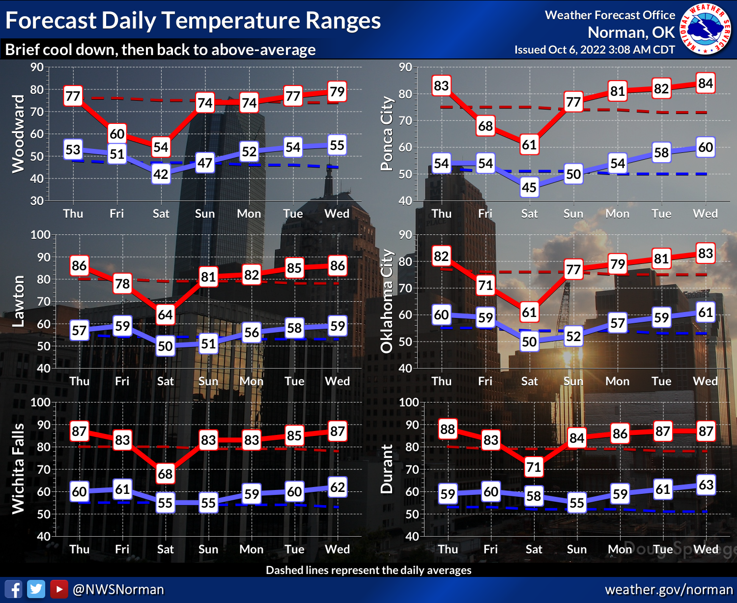
We will get to see true fall weather over the next week, starting with Friday
after the arrival of our strongest cold front of the fall. I would expect to
see highs struggle to reach the 60s where it's drizzly/rainy out west, especially
in NW OK...60s and 70s elsewhere. Then a longer stretch of "hey, shouldn't we
be in the 70s" weather coming back with highs up into the 80s again.
https://ticker.mesonet.org/archive/20221006/nws-norman-7day-temps.png
At any rate, it's something of a change from this.
https://ticker.mesonet.org/archive/20221006/june1-oct5-avg.highs.png
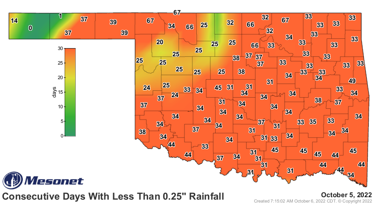
And this.
https://ticker.mesonet.org/archive/20221006/mesonet.rainfall.quarterinch.png
Lasting change? I'll believe it when I see it.
Gary McManus
State Climatologist
Oklahoma Mesonet
Oklahoma Climatological Survey
gmcmanus@mesonet.org
==================================================
The OCS/Mesonet Ticker
https://ticker.mesonet.org/
To subscribe or unsubscribe from the Ticker
or for questions about the Ticker or its content
Phone or Email the Ticker Manager at OCS
Phone: 405-325-2253 Email: ticker@mesonet.org
---------------------------------------------------
-C- Copyright 2024 Oklahoma Climatological Survey
===================================================
|


 Tweet
Tweet