MESONET TICKER ... MESONET TICKER ... MESONET TICKER ... MESONET TICKER ...
September 5, 2023 September 5, 2023 September 5, 2023 September 5, 2023
Every year?
https://ticker.mesonet.org/archive/20230905/sept10-14-rain-outlook.png
Okay, I've had it. Yes, me: famous warm-monger; myself: "bring on summer!"; and
I: "Would be nicer if there were 10 more degrees on that high temperature," have
been brought to my limit.
Tired tired tired tired tired!
"I wonder if he's tired?"
Sometime around 3 p.m. yesterday, as I lugged groceries into the house, sweat
pouring off me (heck, even my groceries were sweating), I thought to myself
"there has to be a better way!" And then I found it in the 7-day forecast.
FALL!
Ladies and Gentlemen, you wanted a miracle, I give you the
F.
B.
I.
No wait, that's "Die Hard."
Ladies and Gentlemen, you wanted a miracle, I give you the
Great.
State.
Fair.
of.
Oklahoma.
https://ticker.mesonet.org/archive/20230905/nws-norman-7day-temps.png
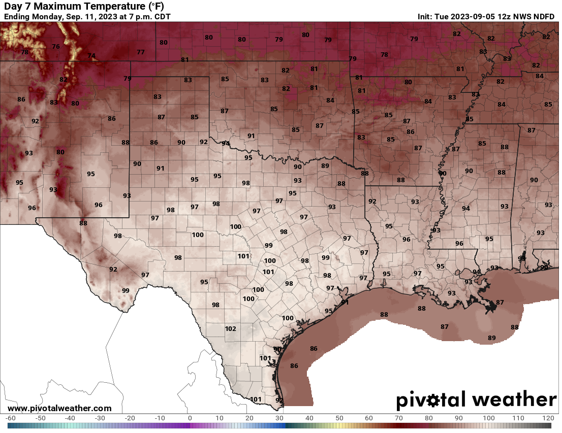
https://ticker.mesonet.org/archive/20230905/monday-forecast-highs.png
Okay okay, let's get technical here. When we see those high temperatures down
into the 80s on Monday, TECHNICALLY that's before the State Fair, but it is
the State Fair week, so it counts. And even more technically, we can take a look
at the afternoon temperatures on Sept. 14, the Fair's opening day, to show that
it's gonna get even better. At least the European forecast model's fantasy-cast.
https://ticker.mesonet.org/archive/20230905/thursday-1pm-temps.png
And let's be honest...cats are much better than dogs (FIGHT ME!), AND even
those lower 90s are better than what we saw this weekend.
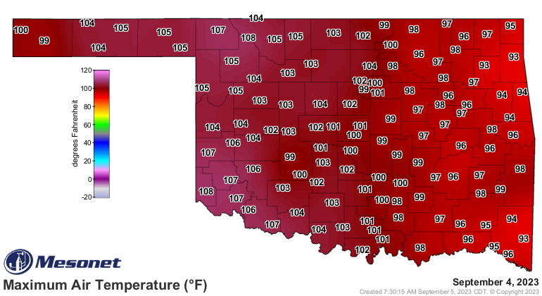
https://ticker.mesonet.org/archive/20230905/yesterdays-highs.png
https://ticker.mesonet.org/archive/20230905/yesterdays-high-heat.index.png
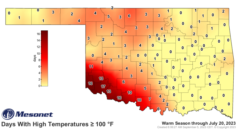
It can't be just me. Come on, who thought we were gonna have an easy summer
going into the third week of July. Show of hands. Ugh, where you been with
those things! Just nod.
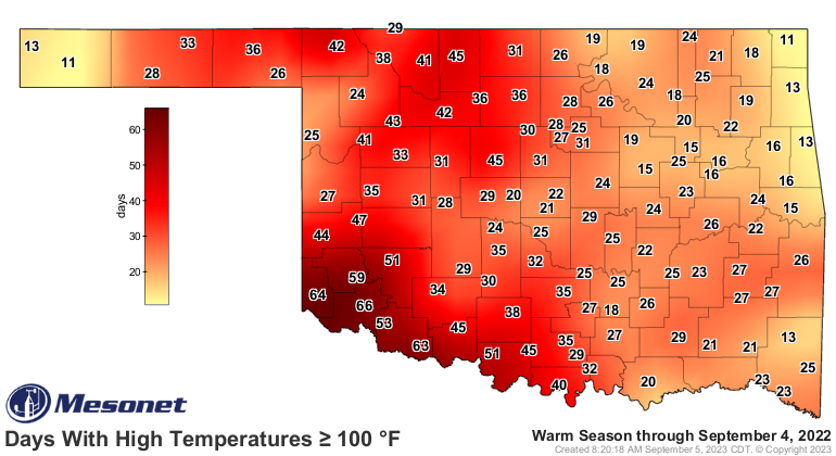
https://ticker.mesonet.org/archive/20230905/tmax_ge100.thru-july20.png
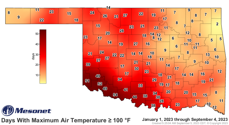
And then where we ended up, through yesterday.
https://ticker.mesonet.org/archive/20230905/tmax.ge100.thru-sept4.png
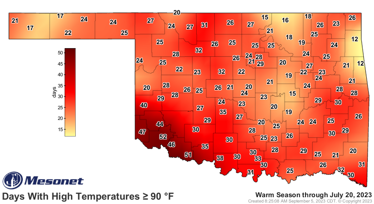
And if 90s are your breaking point...
https://ticker.mesonet.org/archive/20230905/tmax_ge.90.thru-july20.png
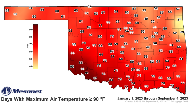
https://ticker.mesonet.org/archive/20230905/tmax.ge90.thru-sept4.png
Exactly! We've packed a summer full of fun into the last 6 weeks or so. Other
than a bit there at the end of July and early August, the weather has been
just to the left of brutal.
https://ticker.mesonet.org/archive/20230905/may-sept4.high-temps.png
So as the upper-level high starts to pull back to the west, we should see more
cold fronts (heck, there's a cold front in the state right now for crying out
loud!)
https://ticker.mesonet.org/archive/20230905/current-wind-gusts.png
and rain chances.
https://ticker.mesonet.org/archive/20230905/7day-rain-forecast.gif
Just be glad we didn't start a month earlier, like last year.
https://ticker.mesonet.org/archive/20230905/tmax_ge100.thru-sept4.2022.png
We'll cover rain and fire tomorrow. Hopefully not fiery rain.
Gary McManus
State Climatologist
Oklahoma Mesonet
Oklahoma Climatological Survey
gmcmanus@mesonet.org
==================================================
The OCS/Mesonet Ticker
https://ticker.mesonet.org/
To subscribe or unsubscribe from the Ticker
or for questions about the Ticker or its content
Phone or Email the Ticker Manager at OCS
Phone: 405-325-2253 Email: ticker@mesonet.org
---------------------------------------------------
-C- Copyright 2024 Oklahoma Climatological Survey
===================================================
|


 Tweet
Tweet