MESONET TICKER ... MESONET TICKER ... MESONET TICKER ... MESONET TICKER ...
October 3, 2012 October 3, 2012 October 3, 2012 October 3, 2012
Drought impacts improve, just in time for cold weather to arrive
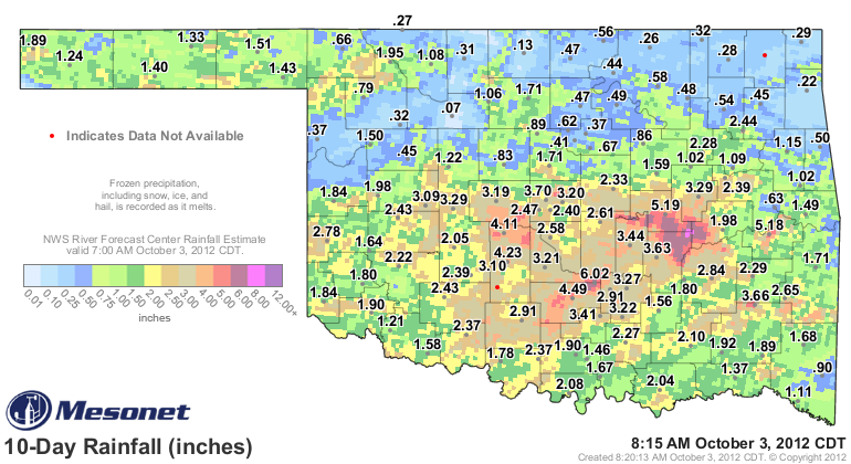
The rains over the last 10 days or so have done wonders for some of our most
persistently and consistently bad drought indicators. First, a look at the 10-day
rainfall map from the Mesonet shows where we had some awesome rainfall totals
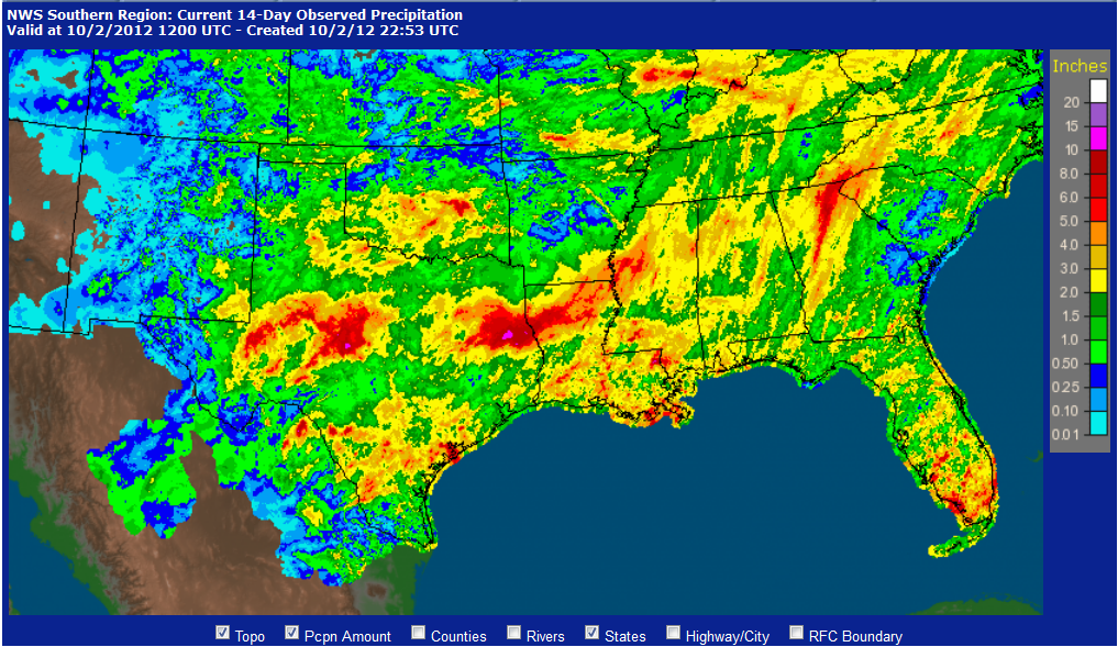
(already widely reported). A broader look shows that Texas benefited even more
from the stalled front/slow-moving upper-level low pressure system/remnants of
Hurricane Miriam scenario with as much as 10 inches of rain in localized areas.
http://ticker.mesonet.org/archive/20121003/rainrfc.240hr.png
http://ticker.mesonet.org/archive/20121003/southern-region-rainfall.png
Word from the Texas State Climatologist, John Nielsen-Gammon of Texas A&M, is that
this rain provided parts of west Texas with its first runoff-producing rainfall
in the last two years! So great news for those folks and great news for those in
Oklahoma that saw improvements as well.
Now you might be asking yourself "But Gary, if things are improved, why do we
still have so much severe-exceptional drought on the map?" Well, first off, it's
odd you would call yourself "Gary" (we've talked about this before), but it's
important to remember that drought has different time-scales. The short-term map
looks pretty good in many parts of the state (sorry, northern OK!), but the long-
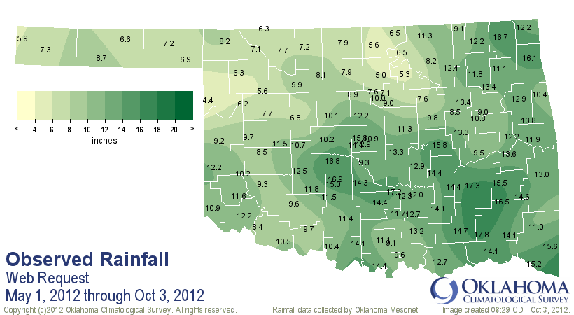
term maps are not quite as pretty. Let's take another look at the moisture since
May 1.
http://ticker.mesonet.org/archive/20121003/may1-oct3-tots.png
http://ticker.mesonet.org/archive/20121003/may1-oct3-dep.png
http://ticker.mesonet.org/archive/20121003/may1-oct3-pct.png
Still wayyyyy too much Bedlam-esque orange and red on those maps (more orange
than red...not a good sign for Sooner fans!). The tabular statistics have not
improved much either. The May-September period from this year is the 4th driest
such span across the state on record dating back to 1895. For northeastern
Oklahoma, it was THE driest May-September on record, at least as measured by
the Mesonet (and compared to long-term NCDC records). But as you can see,
things have gone particularly poorly since May in the northern half of the
state.
-****-
Clim. Div. Total Dep. Rank since 1895 2011
Panhandle 6.89 -6.32 3rd Driest 5.41
North Central 7.00 -10.82 2nd Driest 10.56
Northeast 10.78 -10.44 1st Driest 14.83
West Central 9.10 -7.54 7th Driest 6.57
Central 11.81 -7.70 9th Driest 11.33
East Central 12.57 -8.99 4th Driest 11.48
Southwest 10.64 -6.75 15th Driest 6.18
South Central 12.64 -7.02 17th Driest 8.65
Southeast 14.74 -7.18 16th Driest 11.06
Statewide 10.66 -8.13 4th Driest 9.73
-***-
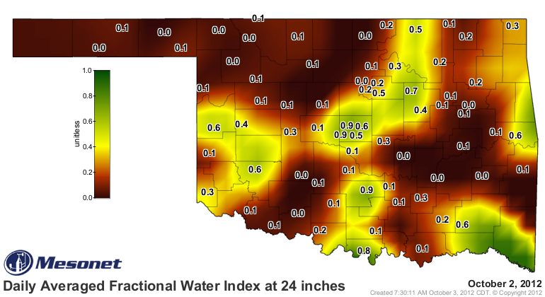
As expected, the parched upper soils drank all the water before much could get
down to the lower depths (check out the map at 24 inches). Still a bleak map at
10 inches for parts of the state, and much of the state at 24 inches.
http://ticker.mesonet.org/archive/20121003/2-inch-soilmoisture.png
http://ticker.mesonet.org/archive/20121003/10inch-soilmoisture.png
http://ticker.mesonet.org/archive/20121003/24inch-soilmoisture.png
-------------------------------------------------------------------------------
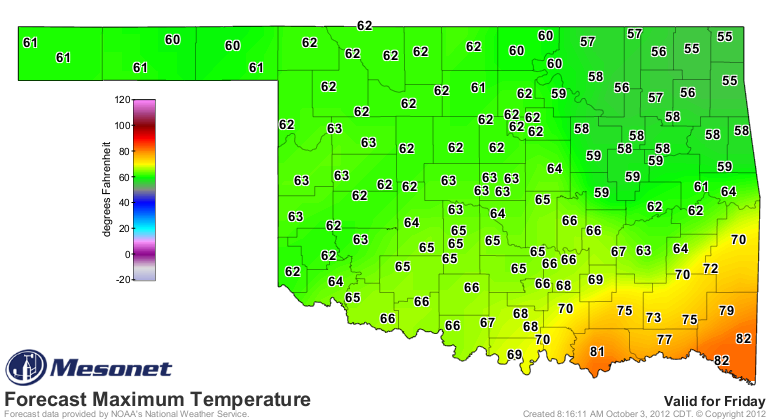
Front-pocalypse-ageddon
I forgot to add "Ragnar?k" to that list of world-ending doom (a by-product of
reading too many "Thor" comics back in the day). But yes, a major cold front
approacheth, bringing us our coldest weather of the season thus far. A very
poorly-timed front for a certain Oklahoma Associate State Climatologist who will
be stuck out early in the morning on Saturday watching his kids' soccer games!
Here's a look at what the NWS is predicting for temperatures this weekend.
http://ticker.mesonet.org/archive/20121003/friday-highs.png
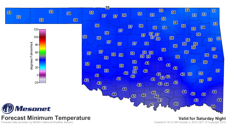
http://ticker.mesonet.org/archive/20121003/saturday-lows.png
http://ticker.mesonet.org/archive/20121003/saturday-highs.png
http://ticker.mesonet.org/archive/20121003/sunday-lows.png
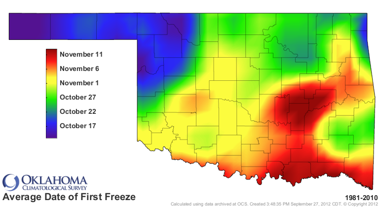
Okay. Brrr. Some areas could possibly hit freezing on Sunday. We haven't seen
the freezing mark on the Mesonet since Boise City hit 32 degrees back on April
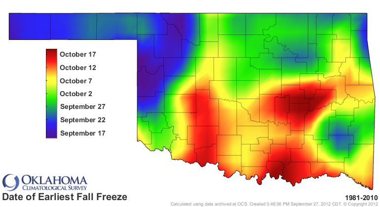
16. Nothing extraordinarily extraordinary here. The earliest fall freeze and
the average first fall freeze normal maps indicate that if it does indeed
freeze in the north, it will definitely be a tad early, but not unheard of.
http://ticker.mesonet.org/archive/20121003/earliest_firstfreeze.1981-2010.png
http://ticker.mesonet.org/archive/20121003/avg_firstfreeze.1981-2010.png
Once again. Brrr.
Gary McManus
Associate State Climatologist
Oklahoma Climatological Survey
(405) 325-2253
gmcmanus@mesonet.org
==================================================
The OCS/Mesonet Ticker
https://ticker.mesonet.org/
To subscribe or unsubscribe from the Ticker
or for questions about the Ticker or its content
Phone or Email the Ticker Manager at OCS
Phone: 405-325-2253 Email: ticker@mesonet.org
---------------------------------------------------
-C- Copyright 2024 Oklahoma Climatological Survey
===================================================
|


 Tweet
Tweet