******************MESONET TICKER UPDATE*******************
OKC has gone to ludicrous heat!
Word from the NWS-Norman, Oklahoma City just tied their all-time record high
temperature with 113 degrees. They have now broken their all-time high minimum
temperature (84 degrees) and tied their all-time high maximum temperature (113
degrees) on the same day. I think these last few days have finally surpassed the
August 9-12, 1936, period as the most ridiculously hot in OKC history. Here are
a few factoids:
This is Oklahoma City's:
* 17th consecutive day at or above 100 degrees
* tied for 3rd longest in history with Aug. 19-Sep. 4, 2000
* #1: 22 days 1936/08/04-1936/08/25
* #2: 19 days 1966/07/01-1966/07/19
* 6th consecutive day above 105 degrees
* tied for 2nd longest in history with 1936/08/08-1936/08/13
* #1: 2011/07/31-2011/08/06
* 3rd consecutive day at/above above 110 degrees
* tied for longest in history with 1936/08/10-1936/08/12
* 3rd consecutive day at/above 113 (so far)
* Only time in history
Highs and lows last 6 days:
2012-07-29 106 77
2012-07-30 107 79
2012-07-31 108 80
2012-08-01 112 79
2012-08-02 112 82
2012-08-03 113 84
Highs and lows from Aug. 9-12, 1936:
1936-08-09 109 80
1936-08-10 112 81
1936-08-11 113 82
1936-08-12 110 83
MESONET TICKER ... MESONET TICKER ... MESONET TICKER ... MESONET TICKER ...
August 3, 2012 August 3, 2012 August 3, 2012 August 3, 2012
A late-starter, but nonetheless...
Our current heat wave really got going on June 23, with a slight hiccup through
the early part of July. And this is separate (sorta) from our warm first seven
months of the year, which as a whole was as much of a function of the absence of
cold weather as the presence of warm weather. I had remarked back then that a
heat wave is a heat wave, and it doesn't have to follow last year's script and
start right when June rolls around. The heat wave of of 1980 didn't get going
until late June. Oklahoma City's first 100-degree day of that summer, which ended
up with a then-infamous record of 50 days, occurred on June 25 (99 degrees on
June 24 ... eerily similar!). They didn't end until August 30. That was about the
same time-frame that Tulsa had as well. The heat began a bit earlier and lasted a
bit longer out west, but that is to be expected.
As with that year, the heat took a bit of time to get going as the drought gained
momentum and the proper upper-air patterns (heat dome) set up. But get going it
has. Let's take a look at some statewide temperature stats since June 23.
-****-
Tmax Tmin Tavg
June 23-Aug 2 100.4 72.0 86.2
June 23-Aug 2 Normal 93.5 69.2 81.4
June 23-Aug 2 Departure 6.9 2.8 4.9
-***-
So the average high temperature across the state through the June 23-Aug. 2
period was over 100 degrees. The low temperatures have not been quite as bad
as the highs, so that's a plus. I say this despite the fact that Oklahoma City
*POSSIBLY* broke its all-time highest minimum temperature record this morning
(from the Norman National Weather Service Office):
"The low temperature at Oklahoma City Will Rogers Airport so far has
been 84 degrees. If it doesn't cool down any more this morning with
the passing showers, this will be warmest low temperature ever
officially recorded at Oklahoma City. The previous warmest low
temperature record was 83 degrees (set on July 25, 1934, August 1,
1934, August 12, 1936 and August 13, 1936.)"
and that Tulsa has did it two days in a row on July 30 and 31 (from the Tulsa
NWS Office ... their screaming, not mine):
700 AM CDT WED AUG 1 2012
...RECORD HIGH MINIMUM TEMPERATURE SET AT TULSA OKLAHOMA...
...ALL TIME RECORD HIGH MINIMUM TEMPERATURE TIED AT TULSA OKLAHOMA...
THE LOW TEMPERATURE IN TULSA, OKLAHOMA YESTERDAY, JULY 31, ONLY
DROPPED DOWN TO 88 DEGREES. THIS BREAKS THE HIGH MINIMUM TEMPERATURE
RECORD OF 82 DEGREES SET IN 2011.
THIS LOW TEMPERATURE ALSO TIED THE ALL TIME RECORD HIGH MINIMUM
TEMPERATURE FOR TULSA OF 88 DEGREES SET ON JULY 30 2012.
For those keeping score, Grandfield has now experienced 143 days with high
temperatures at or above 100 degrees since April 18, 2011. That's 143 out of
last 472 days, or about 30% of the days.
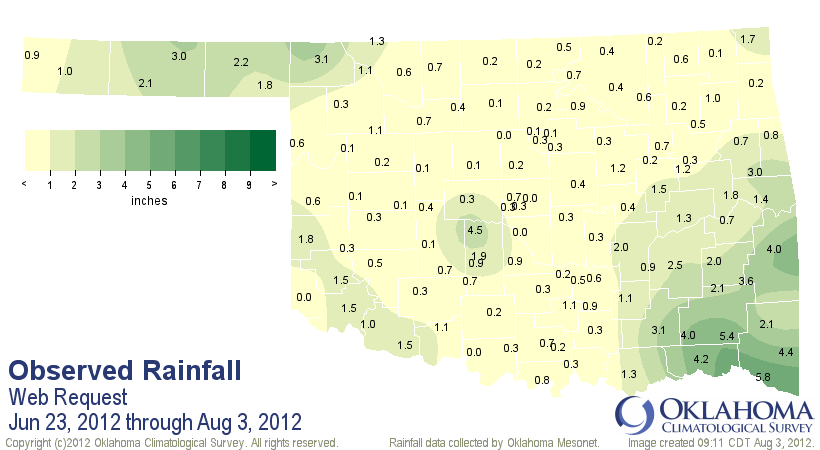
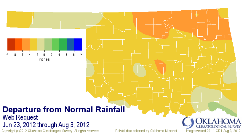
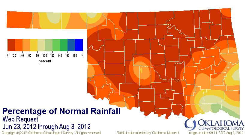
The precipitation stats over that same period have been equally as gruesome,
befitting a momentum-gaining drought. The statewide average rainfall from June
23-Aug 2 was 1.12 inches, 3.01 inches below normal and the 5th driest such
period since 1921.
http://ticker.mesonet.org/archive/20120803/jun23-aug3-tot.png
http://ticker.mesonet.org/archive/20120803/jun23-aug3-dep.png
http://ticker.mesonet.org/archive/20120803/jun23-aug3-pct.png
So now we're at the mercy of that meandering heat dome and the fickleness of
the August rainfall patterns. It continues to look hot (although not quite as
brutal as the last week or so) into next week. Maybe we've spent so much time
looking at last year, we forgot about 1980?
Gary McManus
Associate State Climatologist
Oklahoma Climatological Survey
(405) 325-2253
gmcmanus@mesonet.org
==================================================
The OCS/Mesonet Ticker
https://ticker.mesonet.org/
To subscribe or unsubscribe from the Ticker
or for questions about the Ticker or its content
Phone or Email the Ticker Manager at OCS
Phone: 405-325-2253 Email: ticker@mesonet.org
---------------------------------------------------
-C- Copyright 2024 Oklahoma Climatological Survey
===================================================
|


 Tweet
Tweet