WHOAAAAA NELLIE!! One minor correction to the previous Ticker...October was the
SIXTH wettest on record with a statewide average of 6.78 inches, 3.24 inches
above normal.
That'll teach us to look at the data without refreshing the page again.
Apologies for the added insult to your e-mail inbox.
Gary
MESONET TICKER ... MESONET TICKER ... MESONET TICKER ... MESONET TICKER ...
November 1, 2018 November 1, 2018 November 1, 2018 November 1, 2018
Here comes November!
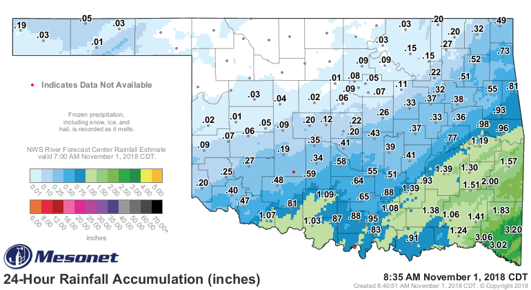
Well that was a joy, walking the kids around in a cold drizzle on Halloween. As
dreary Halloweens go in Oklahoma, that one was right up there. Not quite 1991
bad, or even as cold as last year, but dreary nonetheless. We had snow in the
Panhandle and a cold rain downstate.
http://ticker.mesonet.org/archive/20181101/rainrfc.24hr.png
http://ticker.mesonet.org/archive/20181101/yesterdays-highs.png
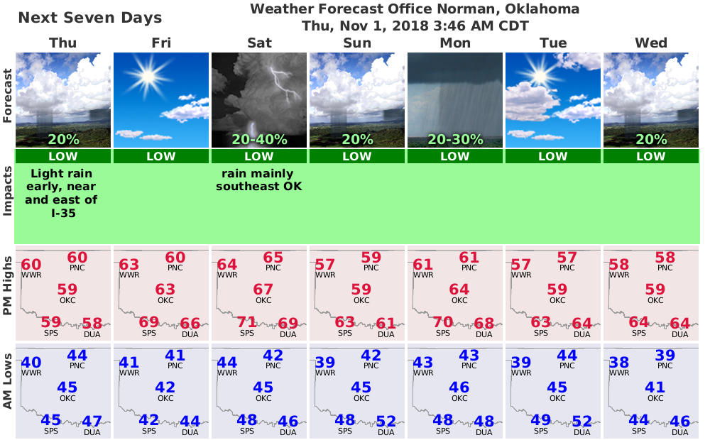
Looks like we're going to be on the roller coaster once again over the next week
as we enjoy(??) this northwesterly flow aloft. Occasional cold fronts and
storm systems will provide us with rain chances off an on as we bounce up and
down on the fall temperature scale.
http://ticker.mesonet.org/archive/20181101/nws-norman-7day-planner.png
As for the lovely experience yesterday...I'll get my revenge. And my kids won't
even know their candy is gone until IT'S. TOO. LATE!
Now let's take a look back at our wild and wacky October and look towards a
somewhat ominous looking November (according to the CPC outlooks).
----------------------------------------------------------------------------------
October Extends Oklahoma’s Rainy Streak
Nov. 1, 2018
Oklahomans experienced the gamut of their state’s annual weather hazards during
October. Flooding rains, extreme heat, an arctic blast, the season’s first snow,
severe thunderstorms, and a slew of tornadoes – all were present during an active
weather month. A weak tornado formed near Fairfax on Oct. 7, damaging roofs and
power poles. Tornadoes struck again just after daybreak on Oct. 9, forming along
the leading edge of a squall line moving across central Oklahoma. Eight tornadoes
touched down that day according to preliminary data from the National Weather
Service, most in and around the Oklahoma City area. The twisters damaged homes
and businesses, but no injuries were reported. The most significant tornado
started near Tinker Air Force Base and produced significant roof damage, later
flipping cars in a Midwest City parking lot. Straight-line wind damage was also
reported across central and eastern Oklahoma with the line of storms.
http://ticker.mesonet.org/archive/20181101/Oct9-storm-reports.png
The preliminary count of at least nine confirmed tornadoes is the third highest
October tally in the state since accurate records began in 1950, behind 1998’s
record total of 27 and 19 in 2001. For excitement of a different sort, the
state’s first measurable snowfall of the season occurred on Oct. 14 in the
western Panhandle, although a few flakes were reported as far south as Clinton
in western Oklahoma. More snow was reported in the Panhandle on a cold and
dreary Halloween day.
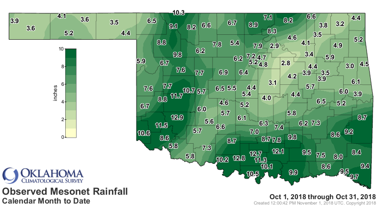
Moisture was plentiful – and at times overwhelming – for the third consecutive
month. According to preliminary data from the Oklahoma Mesonet, October
finished with a statewide average of 6.78 inches, sixth wettest since records
began in 1895 with a surplus of 3.24 inches.
http://ticker.mesonet.org/archive/20181101/October-rain-totals.png
http://ticker.mesonet.org/archive/20181101/October-rain-departure.png
http://ticker.mesonet.org/archive/20181101/October-rain-pct-normal.png
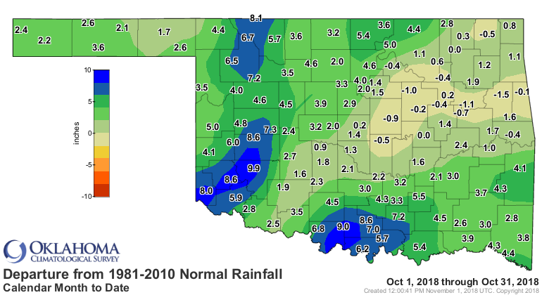
Western and south central Oklahoma were especially wet with widespread totals
of 6-12 inches. Sixty-eight of the Mesonet’s 120 sites had at least 6 inches
for the month, 13 of which had more than 10 inches. Hobart led the state with
12.89 inches. It was drier than normal for some, particularly across
northeastern Oklahoma. Oilton recorded the lowest total at 2.82 inches.
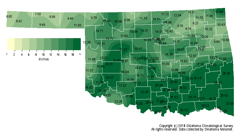
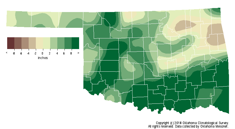
Combined with the abundant moisture of the previous two months, the Mesonet’s
August-October total jumped to 16.01 inches, 6.05 inches above normal to rank
as the fifth wettest August-October on record for Oklahoma.
http://ticker.mesonet.org/archive/20181101/Aug-Oct-rain-totals.png
http://ticker.mesonet.org/archive/20181101/Aug-Oct-rain-departure.png
That’s somewhat similar to last year’s 13th wettest total of 12.61 inches for
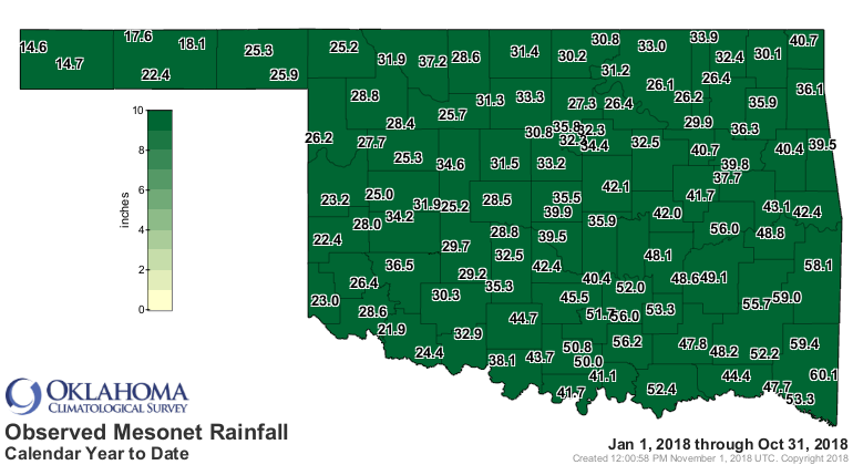
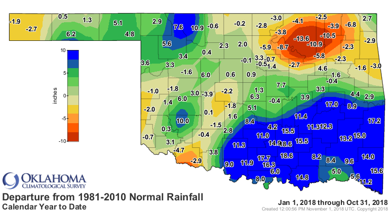
the same period. The January-October average total of 36.16 inches was 4.23
inches above normal, the 17th wettest such period on record.
http://ticker.mesonet.org/archive/20181101/Jan-Oct-rain-totals.png
http://ticker.mesonet.org/archive/20181101/Jan-Oct-rain-departure.png
http://ticker.mesonet.org/archive/20181101/Jan-Oct-rain-pct-normal.png
Mesonet stations saw heat index values of at least 95 degrees 125 times during
the month’s first week, with four of those sites reaching 100 degrees. The
month’s top actual air temperature of 97 degrees was reported at several sites
on Oct. 3. The season’s first freeze arrived on the 14th with temperatures
plunging into the 20s across northern Oklahoma. Wind chills dipped into the
teens on the 14th and 15th during Oklahoma’s first bout of the season with true
arctic air. Eva recorded October’s lowest temperature of 25 degrees on the 16th.
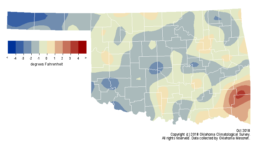
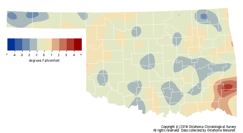
The statewide average temperature fell a degree below normal at 59.9 degrees,
the 30th coolest October on record.
http://ticker.mesonet.org/archive/20181101/Oct-avg-temperatures.png
http://ticker.mesonet.org/archive/20181101/Oct-temperature-depart.png
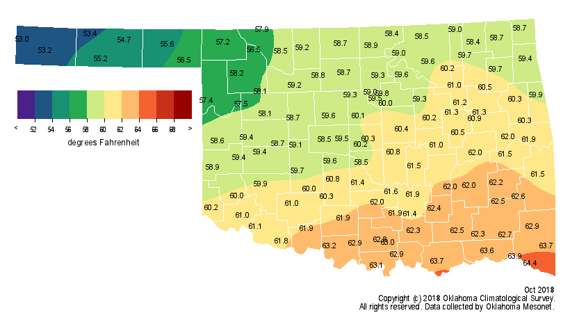
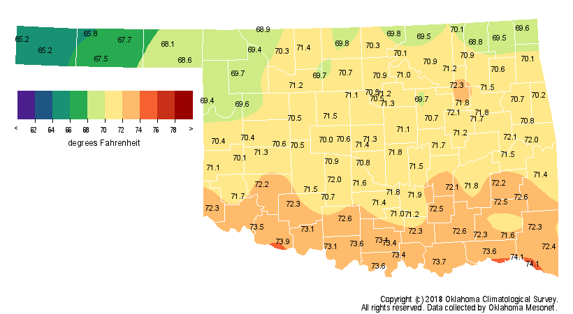
The January-October average of 63.8 degrees was 0.7 degrees above normal to
rank as the 32nd warmest such period since 1895.
http://ticker.mesonet.org/archive/20181101/Jan-Oct-avg-temperature.png
http://ticker.mesonet.org/archive/20181101/Jan-Oct-temperature-depart.png
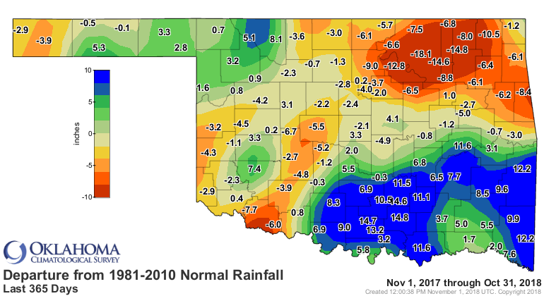
The wet August-October nearly eradicated drought across the state. Drought
dropped from 55 percent of the state at the beginning of August to less than 2
percent at the end of October according to the U.S. Drought Monitor.
http://ticker.mesonet.org/archive/20181101/Jan-Oct-avg-temperature.png
http://ticker.mesonet.org/archive/20181101/Jan-Oct-temperature-depart.png
Far northeast Oklahoma retained the last vestiges of drought as significant
deficits there have continued since October 2017.
http://ticker.mesonet.org/archive/20181101/365day-depart-rain.png
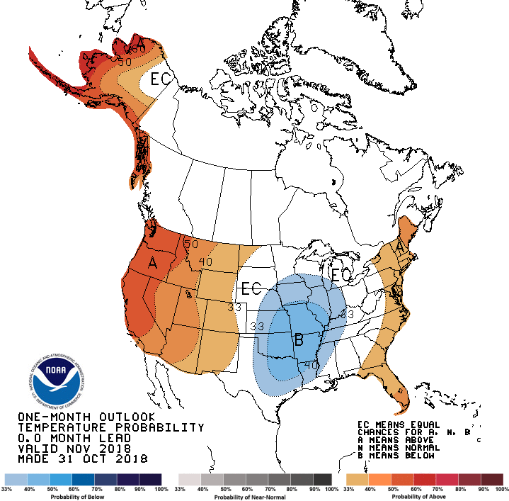
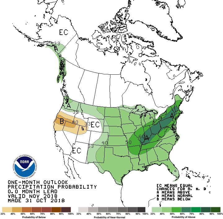
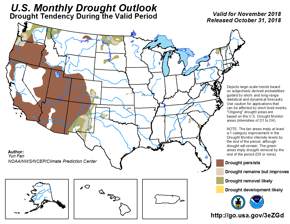
The November outlooks from the Climate Prediction Center indicate increased
odds of below normal temperatures for all but the far western Panhandle, and
above normal precipitation across the entire state. That results in a November
drought outlook with complete drought removal likely in northeastern Oklahoma,
and no new development across the rest of the state.
http://ticker.mesonet.org/archive/20181101/November-temp-outlook.gif
http://ticker.mesonet.org/archive/20181101/November-precip-outlook.gif
http://ticker.mesonet.org/archive/20181101/November-drought-outlook.png
Gary McManus
State Climatologist
Oklahoma Mesonet
Oklahoma Climatological Survey
(405) 325-2253
gmcmanus@mesonet.org
==================================================
The OCS/Mesonet Ticker
https://ticker.mesonet.org/
To subscribe or unsubscribe from the Ticker
or for questions about the Ticker or its content
Phone or Email the Ticker Manager at OCS
Phone: 405-325-2253 Email: ticker@mesonet.org
---------------------------------------------------
-C- Copyright 2024 Oklahoma Climatological Survey
===================================================
|


 Tweet
Tweet