You had one job, Ticker. ONE JOB! And that was to send OCTOBER'S U.S. Monthly
Drought Outlook...not Septembers.
Here's a link to the new one. Will now go eat the egg off my face.
http://www.cpc.ncep.noaa.gov/products/expert_assessment/month_drought.png
MESONET TICKER ... MESONET TICKER ... MESONET TICKER ... MESONET TICKER ...
October 1, 2015 October 1, 2015 October 1, 2015 October 1, 2015
Drought Charges Ahead During September
http://ticker.mesonet.org/archive/20151001/september.jpg
As we enjoy the rain
http://ticker.mesonet.org/archive/20151001/oklahoma-radar.png
and a few days worth of fall
http://ticker.mesonet.org/archive/20151001/current-temps.png
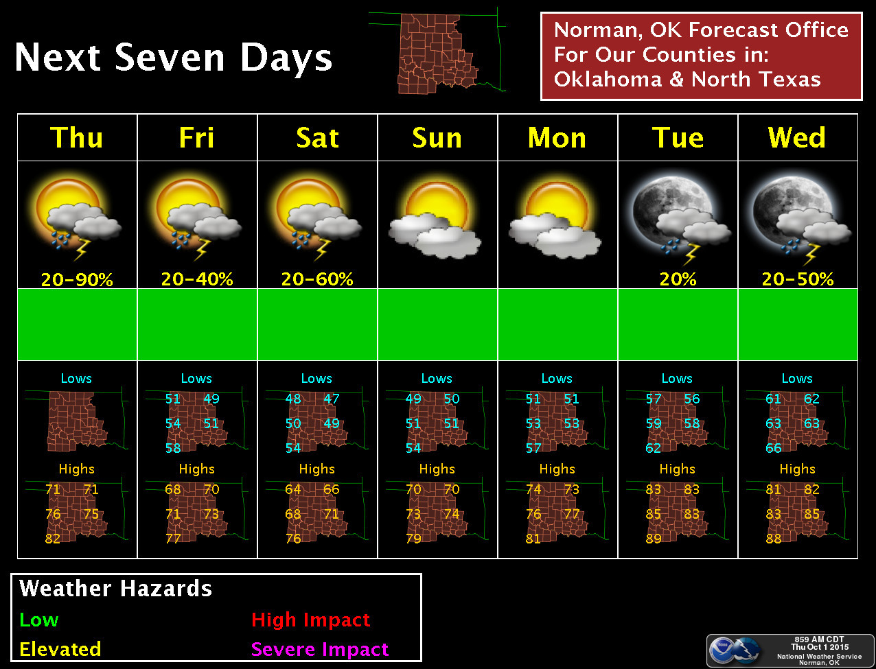
http://ticker.mesonet.org/archive/20151001/nws-norman-7day.jpg
we have but one message for September: way to go, loser! You had one job. ONE
JOB! And that was to keep pace with 1957 for the wettest year on record. But what
did you do? You went all dry on us, allowed flash drought to flourish, and ended
as the 33rd driest (and 15th warmest, which didn't help matters any) September
on record. So now we're pushed back to 4th place, 2.46 behind 1957's record-setting
pace of 41.3 inches. We're also behind 1915's 40.49 inches, and 1945's 39.78
inches.
1915, for crying out loud! You know what happened in 1915? Well, nothing!
Okay, there was that whole "Typhoid Mary" incident. And WWI. But other than
that...meh.
At any rate, here's a look back at September, a dry, hot month that saw drought
spread and little else.
-------------------------------------------------------------------------------
Flash drought continued to spread across southern Oklahoma during a dry, hot
September, and had enveloped nearly 17 percent of the state by month?s end.
http://ticker.mesonet.org/archive/20151001/20150929_OK_trd.png
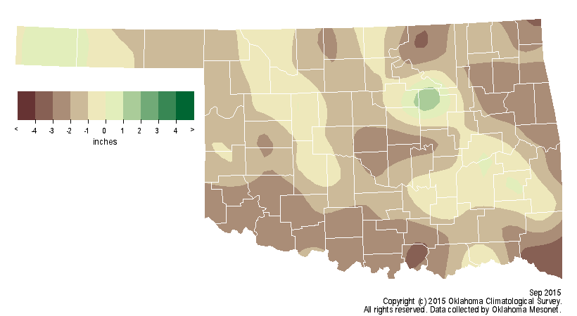
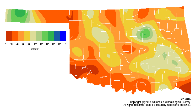
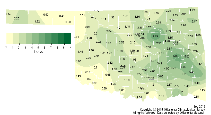
According to preliminary data from the Oklahoma Mesonet, the statewide average
rainfall total was 1.43 inches below normal at 2.1 inches, the 33rd driest
September since records began in 1895. It was particularly dry across south
central and southeastern Oklahoma, areas that had seen record rainfall from
April through July. The Mesonet site at Idabel recorded a measly 0.38 inches of
rainfall for the month, nearly 4 inches below normal and the lowest total in
the state. Eighteen of the 119 Mesonet sites recorded less than an inch of rain
during September, concentrated mostly in southern Oklahoma. Fifty-seven
stations received less than 2 inches. There were a few isolated areas that had
good moisture, however. Oilton reported 7.5 inches, and seven other stations
recorded at least 4 inches of rain.
http://ticker.mesonet.org/archive/20151001/sept-rain-depart.png
http://ticker.mesonet.org/archive/20151001/sept-rain-pct.png
http://ticker.mesonet.org/archive/20151001/sept-rain-totals.png
The dry September combined with a dry August to enable the flash drought to
develop and intensify. The August-September statewide average of 4.54 inches
was over 2 inches below normal and the 33rd driest on record. In some cases,
the deficits stretch even farther back. Madill in south central Oklahoma
recorded nearly 43 inches of rain between April 13 and July 8, but only 1.16
inches since. Idabel, so dry during September, has seen less than an inch
dating back to July 9. The drier than normal months also took a bite out of
2015?s chances to eclipse 1957 as the wettest year on record for Oklahoma. The
January-September statewide average rainfall total of 38.84 inches is still
10.45 inches above normal, but fell to fourth place in the rankings behind
1957?s top mark of 41.3 inches. The record-setting total that year was 47.88
inches. In order to surpass 1957?s total, 2015 has a mere three months to add
another 9 inches. The normal October-December precipitation total for Oklahoma
is 8.11 inches.
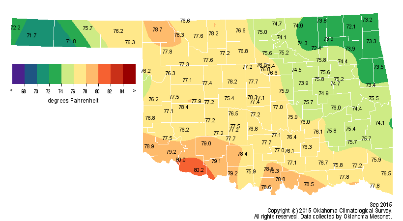
Despite a few cool spells, the majority of September was warmer than normal,
and emphatically hot at times. Those periods of intense heat further worsened
moisture stress on the state and invigorated the flash drought. The statewide
average temperature according to preliminary Mesonet data was 76.3 degrees, 4
degrees above normal to rank this September as the 15th warmest on record.
http://ticker.mesonet.org/archive/20151001/sept-tavg-depart.png
http://ticker.mesonet.org/archive/20151001/sept-tavg.png
The Mesonet recorded its last triple-digit temperature for the year, barring
any unusual October occurrences, on Sept. 17 with readings of 103 degrees at
Freedom and Buffalo. September?s highest temperature was 108 degrees at Freedom
on the seventh while the lowest was a chilly 42 degrees at Kenton on the 19th.
September boosted the year-to-date average temperature to 63.6 degrees, 0.2
degrees above normal, to rank the January-September ranking to 47th warmest.
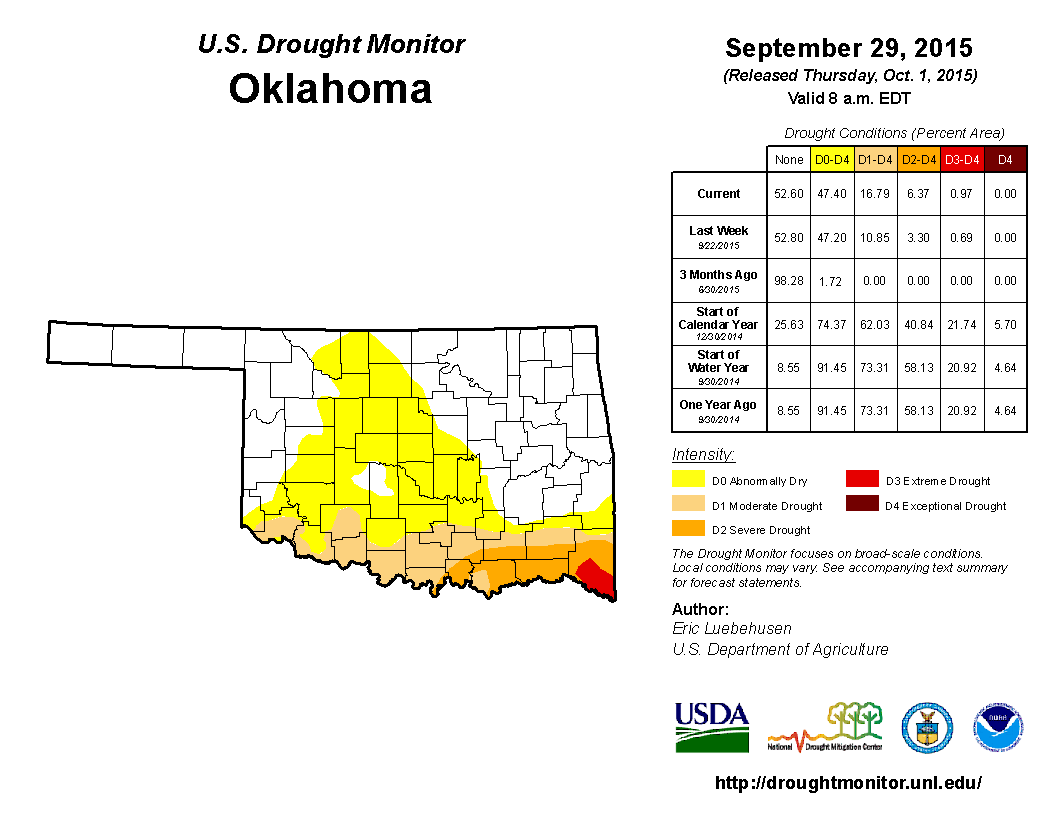
Although most of the state remains drought free, the latest U.S. Drought
Monitor report does show over 30 percent of the state in ?abnormally dry?
conditions. While that designation is not considered drought by the Drought
Monitor, it can be considered a pre-cursor to further drought development. Of
the 16.79 percent of the state in drought, 10.42 percent was considered
?moderate,? 5.4 percent ?severe? and 0.97 percent ?extreme.? The Drought
Monitor?s intensity scale slides from moderate-severe-extreme-exceptional, with
exceptional being the worst classification.
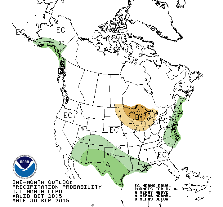
The October precipitation outlook from the Climate Prediction Center (CPC)
indicates increased odds of above normal moisture for the southwestern half of
the state. The temperature outlook was non-committal with equal chances of
above-, below- or near-normal conditions.
http://ticker.mesonet.org/archive/20151001/october-precip-outlook.gif
http://ticker.mesonet.org/archive/20151001/october-temp-outlook.gif
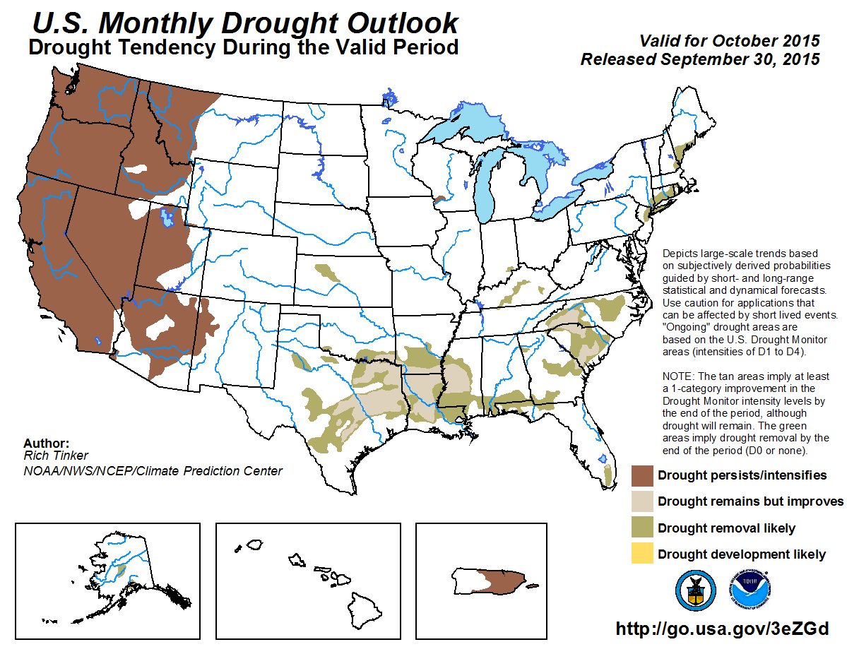
The precipitation outlook lends confidence for possible drought relief. The
U.S. Monthly Drought Outlook portrays the drought stricken areas in southern
Oklahoma as seeing drought either improving or disappearing by the end of the
month.
http://ticker.mesonet.org/archive/20151001/october-drought-outlook.png
Gary McManus
State Climatologist
Oklahoma Mesonet
Oklahoma Climatological Survey
(405) 325-2253
gmcmanus@mesonet.org
==================================================
The OCS/Mesonet Ticker
https://ticker.mesonet.org/
To subscribe or unsubscribe from the Ticker
or for questions about the Ticker or its content
Phone or Email the Ticker Manager at OCS
Phone: 405-325-2253 Email: ticker@mesonet.org
---------------------------------------------------
-C- Copyright 2024 Oklahoma Climatological Survey
===================================================
|


 Tweet
Tweet