MESONET TICKER ... MESONET TICKER ... MESONET TICKER ... MESONET TICKER ...
December 19, 2012 December 19, 2012 December 19, 2012 December 19, 2012
Shocking news all around
Wow, so the big snowstorm we worried about eight days out is falling apart? I'm
shocked ... SHOCKED I SAY! The only way to make less money than predicting rain
during a drought is to predict it in the form of a blizzard more than a week out!
But, that's why you saw all the cautionary words in all the descriptions. And
while the storm seems to be heading the "other way," there ain't nothing saying
it still can't change back to a snowstorm for us in the next six days. Maybe not
a blizzard, but anywhere from flurries to a few inches could still show up. The
HPC has a new experimental 7-day total rainfall forecast out, so we'll take a look
at that. This is for today through the morning of the 26th.
http://ticker.mesonet.org/archive/20121219/7day-rain.gif
So there will still be some moisture around, and any moisture these days is
beneficial, unless you're a mall Santa with babies sitting on your lap. And that's
probably why the CPC has picked up on a broad area of increased odds for above
normal precipitation across the southeast, and Oklahoma as well.
http://ticker.mesonet.org/archive/20121219/dec24-28-rainfall-odds.gif
Here's the kicker there though. Increased odds of above normal precip in late
December isn't necessarily something to write home about. We're just now
entering the driest time of the year in Oklahoma. Oh to heck with it. We're in
a desperate drought, might as well shout it from the rooftops!
-------------------------------------------------------------------------------
Wind?
The storm system that's about to traverse the Panhandle and head up to the
northeast is providing us with lots of lovely wind today. Wind gusts could
exceed 60 mph out in the Panhandle and far western Oklahoma. That's earned
much of that part of the state a high wind warning, a high wind watch, and
points farther east get a wind advisory.
60 mph wind gusts in the Panhandle? Folks out there call that "Tuesday."
However, the conditions are also coming together for fire danger, especially
down in the southwest where a red flag fire warning has been issued by the
NWS.
"...RED FLAG WARNING IN EFFECT FROM NOON TODAY TO 6 PM CST THIS
EVENING FOR STRONG WINDS AND LOW HUMIDITY FOR SOUTHWEST
OKLAHOMA AND WESTERN NORTH TEXAS.
THE NATIONAL WEATHER SERVICE IN NORMAN HAS ISSUED A RED FLAG
WARNING...WHICH IS IN EFFECT FROM NOON TODAY TO 6 PM CST THIS
EVENING. THE FIRE WEATHER WATCH IS NO LONGER IN EFFECT.
* WIND....SOUTHWEST 25 TO 30 MPH WITH GUSTS NEAR 45 MPH.
* HUMIDITY...18 TO 20 PERCENT.
* TEMPERATURE...68 TO 75 DEGREES.
* IMPACTS...CONDITIONS FAVORABLE FOR WILDFIRES ARE POSSIBLE. ANY
FIRES THAT DEVELOP WILL SPREAD RAPIDLY AND WILL BE VERY
DIFFICULT TO CONTAIN."
To top it off, the state's going to need a very large can of Pledge once the
dust settles. Check out the U.S. warning map for today from the NWS ... it
has just about everything.
http://ticker.mesonet.org/archive/20121219/nws-warning-map.png
So I guess we should stop complaining. At least we don't have a "heavy freezing
spray" warning like Alaska does. I wonder if they have a Braum's up there?
-------------------------------------------------------------------------------
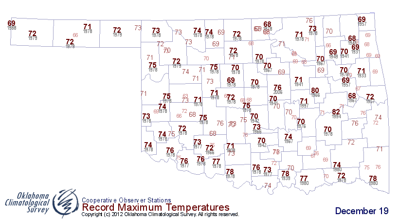
Parting shot ... watch for some possible record highs to fall today down south,
and most assuredly the record Mesonet high for today (71 degrees at Waurika
from 1997) will fall.
Here are the forecast highs from the NWS and the records for today.
http://ticker.mesonet.org/archive/20121219/wednesday-highs.png
http://ticker.mesonet.org/archive/20121219/record-highs-dec19.png
Gary McManus
Associate State Climatologist
Oklahoma Climatological Survey
(405) 325-2253
gmcmanus@mesonet.org
==================================================
The OCS/Mesonet Ticker
https://ticker.mesonet.org/
To subscribe or unsubscribe from the Ticker
or for questions about the Ticker or its content
Phone or Email the Ticker Manager at OCS
Phone: 405-325-2253 Email: ticker@mesonet.org
---------------------------------------------------
-C- Copyright 2024 Oklahoma Climatological Survey
===================================================
|


 Tweet
Tweet