MESONET TICKER ... MESONET TICKER ... MESONET TICKER ... MESONET TICKER ...
December 4, 2013 December 4, 2013 December 4, 2013 December 4, 2013
In praise of the thin blue line
http://ticker.mesonet.org/archive/20131204/poltergeist.jpg
Nope, not a police story today, just reminding folks of another cool feature on
the Oklahoma Mesonet website as the arctic blast (I like the Oreo blast at Sonic
... it's so creamy and delicious with those big chunks of Oreos and whipped cream
and ... but wait, I digress), moves through the state. When the precipitation
starts, obviously the position of the air that has reached the freezing point is
critical. The Oklahoma Mesonet folks have put the freezing line on a state radar
composite image so you can track it yourself (instead of trying to watch the
air temperature map and the radar at the same time). Here's the link so you can
check it out for yourself.
http://www.mesonet.org/index.php/weather/map/state_radar_composite/radar
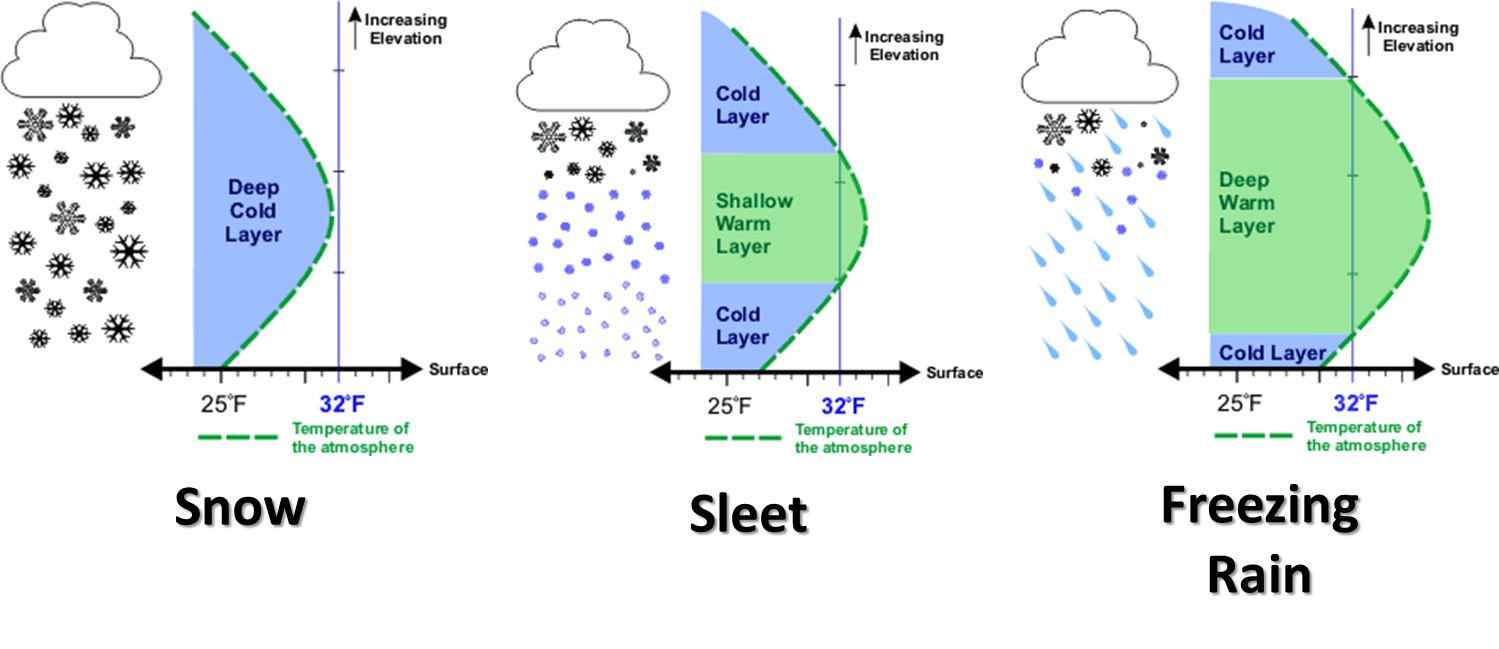
Pretty cool, eh? And remember, the type of precipitation you are getting depends
on the temperature profile as you go UP in the atmosphere as well.
http://ticker.mesonet.org/archive/20131125/winter-precip-types.png
I would not suggest going up in the atmosphere on days like this, however. Try
to keep your feet on the ground. By the way, it's a thin yellow line on the
air temperature map.
http://www.mesonet.org/index.php/weather/map/air_temperature/air_temperature
So now that the front is here, it's all over but the shouting ... and the
several inches of sleet, snow and ice, the power outages, the wrecks, the
run on Braum's bread and milk, snow shovels at Ace Hardware, etc. For the
particulars, we once again turn to our friends at the local NWS offices.
First off, let's take a look at the NWS warning map:
http://ticker.mesonet.org/archive/20131204/nws-warning-map.png
* We have a "winter weather advisory" in effect for the Panhandle for the
possibility of 1-3 inches of snow with localized amounts of up to 5 inches.
* We have a "winter storm watch" in effect for much of central and southern
Oklahoma for the possibility of significant amounts of snow, sleet and freezing
rain, including the chance for "a serious ice storm" in south central and
southeast Oklahoma." This watch could be transitioned to a warning at any time,
so keep in touch with the NWS Norman office throughout the day.
* We have a "winter storm warning" in effect for the eastern one-third of the
state for the possibility of lots and lots of nasty stuff.
Northwestern Oklahoma seems to get left out of the worst stuff, an oddity for
that to occur two winter storms in a row. They are probably both lamenting and
grateful for that. They do need the moisture.
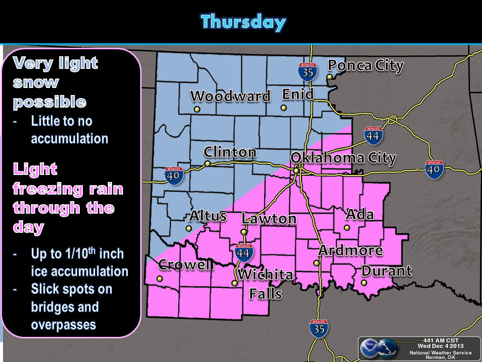
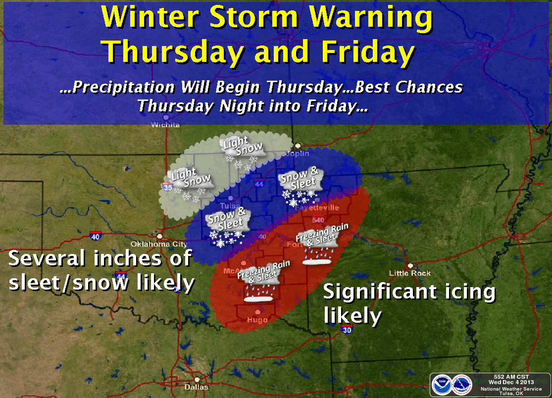
Here are some graphics from the local offices to give you a better sense of
the timing and locations.
http://ticker.mesonet.org/archive/20131204/nws-amarillo.jpg
http://ticker.mesonet.org/archive/20131204/nws-amarillo2.jpg
http://ticker.mesonet.org/archive/20131204/nws-norman1.jpg
http://ticker.mesonet.org/archive/20131204/nws-norman2.jpg
http://ticker.mesonet.org/archive/20131204/nws-norman3.jpg
http://ticker.mesonet.org/archive/20131204/nws-norman4.jpg
http://ticker.mesonet.org/archive/20131204/nws-tulsa.png
Today's forecast highs will possibly set records up in the Panhandle for being
on the cold side. Here are the forecast highs from the NWS and the record low
maximum temperatures for the December 4. And check out tomorrow's highs ...
most definitely in record-setting territory.
http://ticker.mesonet.org/archive/20131204/today-forecast-highs.png
http://ticker.mesonet.org/archive/20131204/today.lotmax.records.png
http://ticker.mesonet.org/archive/20131204/thursday-highs.png
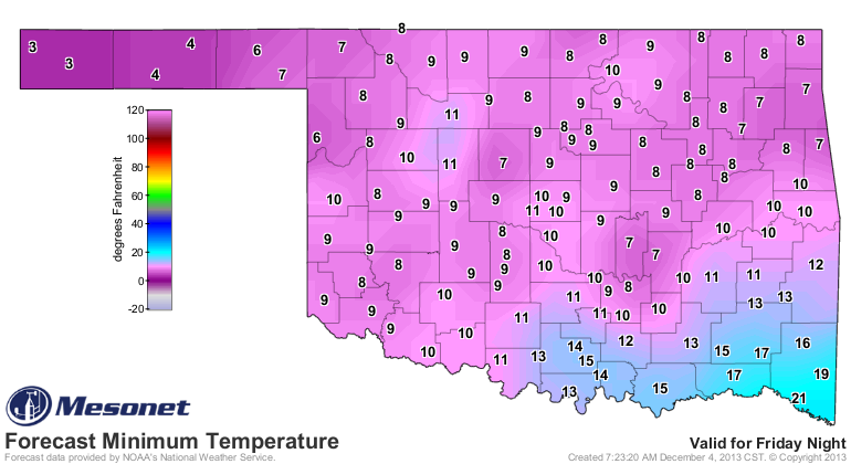
Now if none of that scares ya, this will ... pipe-bursting, record cold
temperatures for Saturday.
http://ticker.mesonet.org/archive/20131204/saturday-morning-lows.png
Gary McManus
Associate State Climatologist
Oklahoma Climatological Survey
(405) 325-2253
gmcmanus@mesonet.org
==================================================
The OCS/Mesonet Ticker
https://ticker.mesonet.org/
To subscribe or unsubscribe from the Ticker
or for questions about the Ticker or its content
Phone or Email the Ticker Manager at OCS
Phone: 405-325-2253 Email: ticker@mesonet.org
---------------------------------------------------
-C- Copyright 2024 Oklahoma Climatological Survey
===================================================
|


 Tweet
Tweet