MESONET TICKER ... MESONET TICKER ... MESONET TICKER ... MESONET TICKER ...
August 5, 2011 August 5, 2011 August 5, 2011 August 5, 2011
A return to La Ni?a (and a continuation of drought) looks possible for 2012
Much as I have feared over the last month, long-range sea surface temperature
computer models and atmospheric conditions are pointing more and more towards
another possible La Nina event for this winter. Those factors and others have
prompted the National Weather Service's Climate Prediction Center to issue a La
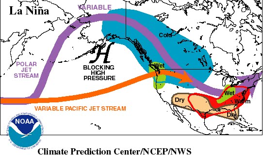
Ni?a watch. Remember, La Ni?a CAN (not DOES) mean a warmer and drier than
normal winter in Oklahoma with a jet stream/storm track pushed farther to the
north.
http://ticker.mesonet.org/archive/20110805/typical_la_nina_impacts.jpg
A La Ni?a watch is very much like the tornado watches Oklahomans are so
familiar with, except they look forward on a climate time scale. A La Ni?a
watch is issued when conditions are favorable for the development of La Ni?a
conditions within the next six months.
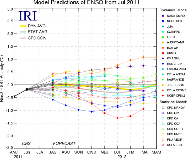
Most of the long-range model forecasts expect neutral conditions to continue
into fall. After that, however, the news is not as good. Here's a look at
some of those model runs. The lines that go above 0.5C indicate El Ni?o, those
between 0.5C and -0.5C depict neutral conditions, and those below -0.5C
represent La Ni?a forecasts.
http://ticker.mesonet.org/archive/20110805/models1.png
From the CPC's own words:
"Beyond the early fall, the forecasts are less certain with half of the models
persisting neutral conditions continuously through early 2012. Along with a
few other models, the latest runs from the NCEP Climate Forecast System (CFS)
models predict La Ni?a to re-develop during the fall. This forecast is also
supported by the ongoing La Ni?a-like tropical atmosphere, subsurface
temperature trends, and the historical tendency for significant wintertime La
Ni?a episodes to be followed by relatively weaker La Ni?a episodes the
following winter. Therefore, neutral conditions are expected to continue into
the Northern Hemisphere fall 2011, with neutral or La Ni?a equally likely
thereafter."
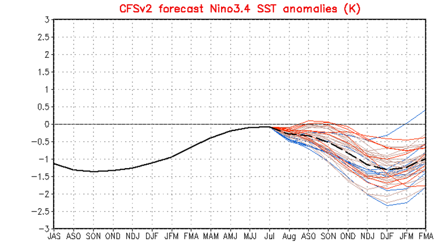
Here's a look at the CPC/National Centers for Environmental Prediction (NCEP)
forecast model runs. Each line is a different model run with the dashed black
line the mean of those forecasts. Again, those that dip below -0.5 are the
ones of interest.
http://ticker.mesonet.org/archive/20110805/CFSv2_models.png
This is particularly bad news for the Southern Plains and Oklahoma since another
drier-than-normal cool season could result. Last winter's La Ni?a was a primary
factor in the development and persistence of the current drought and was timed
perfectly to devastate the 2011 wheat crop. Another such episode would not be
welcomed by agricultural producers, to say the least. The resulting U.S.
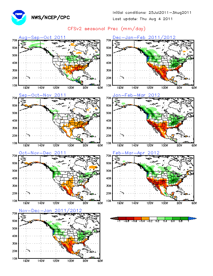
precipitation forecasts give a hint of the possible dryness if La Ni?a does in
fact return.
http://ticker.mesonet.org/archive/20110805/US-precip-forecasts.gif
The forecast dryness is not extreme during the winter months but then again
that is the driest time of the year so there is less of a reduction possible.
Notice in particular the intensity of the precipitation deficits forecast in
western Oklahoma late next winter. Even if the dryness was not significant, ANY
hint of drier than normal weather is terrible news given the state of the
current drought. The statewide average rainfall total of 16.57" since October
1, 2010, is nearly 14" below normal and the driest such period on record in
Oklahoma since records began in 1895.
Let's cut to the chase. A return to La Nina is not certain. If it does happen,
it's not a guarantee of a continuation of drought, just an increased likelihood.
Other climate factors can have a say. However, it bears watching.
Gary McManus
Associate State Climatologist
Oklahoma Climatological Survey
(405) 325-2253
gmcmanus@mesonet.org
==================================================
The OCS/Mesonet Ticker
https://ticker.mesonet.org/
To subscribe or unsubscribe from the Ticker
or for questions about the Ticker or its content
Phone or Email the Ticker Manager at OCS
Phone: 405-325-2253 Email: ticker@mesonet.org
---------------------------------------------------
-C- Copyright 2024 Oklahoma Climatological Survey
===================================================
|


 Tweet
Tweet