MESONET TICKER ... MESONET TICKER ... MESONET TICKER ... MESONET TICKER ...
July 1, 2019 July 1, 2019 July 1, 2019 July 1, 2019
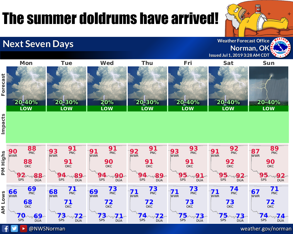
Goodbye June, hello summer doldrums
http://ticker.mesonet.org/archive/20190701/doldrums.png
What's to say? It's gonna be hot, then not so hot. There will be a small chance of
rain, then a better chance of rain. Same as it ever was, right? These summer
storms will provide a few folks with lots of rainfall wherever they pop up.
Typical for this time of year, the storms will pop up, not move much, then die
down quickly, only to form again somewhere close by. Sort of like those
salespeople at our local furniture stores. Oh, I'll just look for myself for now.
"Very well sir, I'll let you look by walking behind you 6 inches away."
Anyway, perhaps a bit more unsettled weather coming for next weekend, which in
this case is better than the week itself, since July 4th is coming in (checks
notes)...4 days. Some might say 3, but the day has barely started. I says 4.
How about we talk June? Sorry, I'm going to anyway. It was certainly more
exciting than the weather we're seeing now. Some gargantuan rain totals for
the May-June period, and one of our most tornadoey (don't look it up, I just made
it up) years on record thus far.
So let's go back to June. Maybe it will turn out better this time.
-------------------------------------------------------------------------------
Unsettled Weather Continues During June
July 1, 2019
The tumultuous weather of May calmed somewhat with the transition to June, the
first month of climatological summer. Despite the seasonal switch, however,
there was still plenty of unsettled weather in store for Oklahoma. Western
Oklahoma managed to dry out just enough to see the winter wheat harvest make
significant advances by the end of the month. Other areas continued to see an
active weather pattern with heavy rains, large hail, severe winds, and even
tornadoes. At least eight tornadoes touched down during June according to the
National Weather Service, bringing the 2019 annual total up to 115. The eight
twisters during June is not that unusual ľ the average for the month is 7.3 ľ
but the annual total ranks as the third highest for the state since accurate
records began in 1950. Only 1999ĺs count of 145 and 2011ĺs 119 rank higher.
Regardless of the total, 2019ĺs tornadoes have been particularly costly to
lives and property. This yearĺs tornadoes killed four and injured another 41,
and produced significant property and infrastructure damage in their wake.
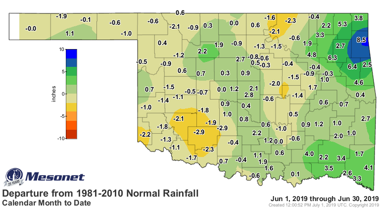
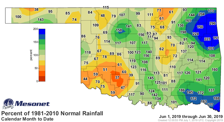
According to preliminary data from the Oklahoma Mesonet, the statewide average
rainfall total for the month was 5 inches, 0.48 inches above normal to rank as
the 33rd wettest June since records began in 1895. A bit of a drying out
occurred across western and parts of north central Oklahoma, but ample moisture
along the Interstate 35 corridor and the eastern third of the state more than
made up for those deficits. Southeastern Oklahoma was the wettest region of the
state at 7.17 inches, a surplus of 2.52 inches and the 15th wettest June for
that area. The northeast was not far behind at 7.11 inches, their 21st wettest
June with a surplus of 1.88 inches. The southwest experienced a deficit of 1.67
inches on average for their 44th driest June on record. Jay led the state at
12.77 inches, a surplus of 8.6 inches. Fifty-five of the Mesonetĺs 120 stations
recorded rainfall totals of 5 inches or greater. Bringing up the rear was Eva
at 1.12 inches, although four other Mesonet sites ľ Acme, Freedom, Hollis and
Medicine Park ľ joined Eva by recording less than 2 inches of rain for the
month.
http://ticker.mesonet.org/archive/20190701/june-rain-totals.png
http://ticker.mesonet.org/archive/20190701/june-rain-departure.png
http://ticker.mesonet.org/archive/20190701/june-rain-pct-normal.png
Combined with the gargantuan totals of May, the June rains propelled the
two-month periodĺs statewide average to 15.52 inches, the fifth wettest on
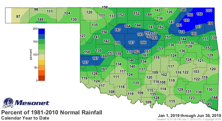
record with a surplus of 6.05 inches. The January-June average of 26.46 inches
exceeded normal by 7.43 inches to rank as the seventh wettest such period on
record. That six month value is only 10.04 inches less than the normal annual
total of 36.5 inches for the state.
http://ticker.mesonet.org/archive/20190701/jan-june-totals.png
http://ticker.mesonet.org/archive/20190701/jan-june-rain-departure.png
http://ticker.mesonet.org/archive/20190701/jan-june-rain-pct.png
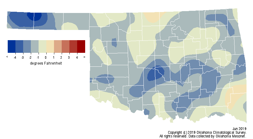
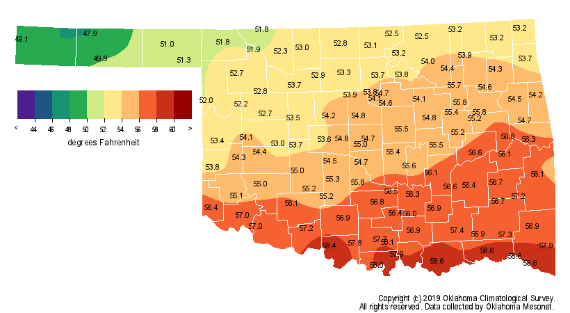
Given the enhanced rainfall and associated cloudiness, June was destined to be
a cool month. The statewide average temperature of 75.1 degrees was 1.4 degrees
below normal to rank as the 28th coolest June since records began in 1895.
The first triple-digit reading of the year occurred on the 20th at Altus and
Hollis, both reaching exactly 100 degrees. Those extreme temperatures were in
short supply during June, however, with only 21 recorded temperatures of 100
degrees or more across the 120 Mesonet sites. Fifteen of those readings
occurred on June 21. Hollis led the Mesonet with 104 degrees on the 21st while
Eva recorded the lowest temperature of 40 degrees on the 10th. The heat index
was bound to spike at times thanks to the excessive rains of May and June. Heat
index values rose above 110 degrees across the state on June 20 and 21, with
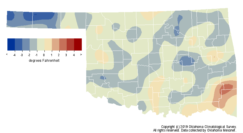
Kingfisher reaching 114 degrees on the 21st. The first six months of the year
remained on the cool side with a statewide average of 54.9 degrees, 0.9 degree
below normal and the 45th coolest January-June on record.
http://ticker.mesonet.org/archive/20190701/june-avg-temps.png
http://ticker.mesonet.org/archive/20190701/june-temps-depart.png
http://ticker.mesonet.org/archive/20190701/jan-june-avg-temps.png
http://ticker.mesonet.org/archive/20190701/jan-june-temps-departure.png
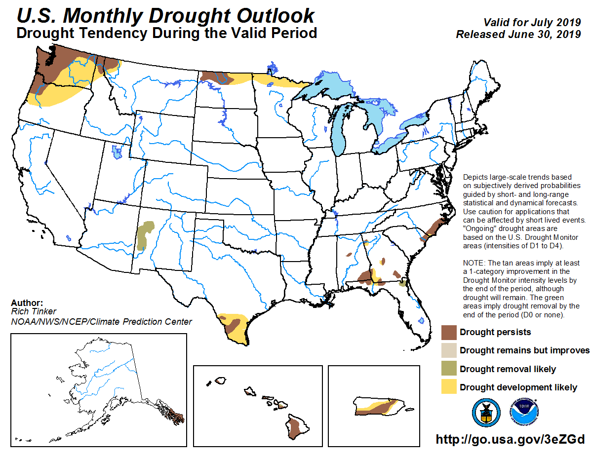
Drought was of little concern during June. In fact, no drought conditions have
been seen in Oklahoma since the March 12 U.S. Drought Monitor, a span of 15
weeks. That duration of drought inactivity in Oklahoma has not occurred since the 38
consecutive drought-free weeks between Sept. 15, 2009, and June 1, 2010. The
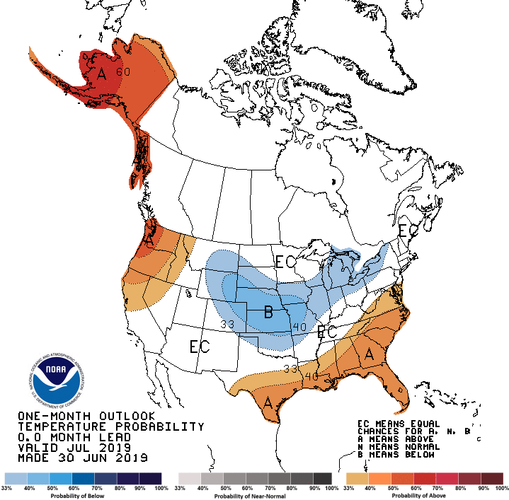
July temperature and precipitation outlooks from the Climate Prediction Center
show increased odds of above normal precipitation and below normal temperatures
for most of the state. Accordingly, CPCĺs July U.S. Drought Outlook did not
foresee any drought development occurring within Oklahoma.
http://ticker.mesonet.org/archive/20190701/july-rain-outlook.gif
http://ticker.mesonet.org/archive/20190701/july-temp-outlook.gif
http://ticker.mesonet.org/archive/20190701/july-drought-outlook.png
Gary McManus
State Climatologist
Oklahoma Mesonet
Oklahoma Climatological Survey
(405) 325-2253
gmcmanus@mesonet.org
==================================================
The OCS/Mesonet Ticker
https://ticker.mesonet.org/
To subscribe or unsubscribe from the Ticker
or for questions about the Ticker or its content
Phone or Email the Ticker Manager at OCS
Phone: 405-325-2253 Email: ticker@mesonet.org
---------------------------------------------------
-C- Copyright 2024 Oklahoma Climatological Survey
===================================================
|


 Tweet
Tweet