MESONET TICKER ... MESONET TICKER ... MESONET TICKER ... MESONET TICKER ...
July 2, 2024 July 2, 2024 July 2, 2024 July 2, 2024
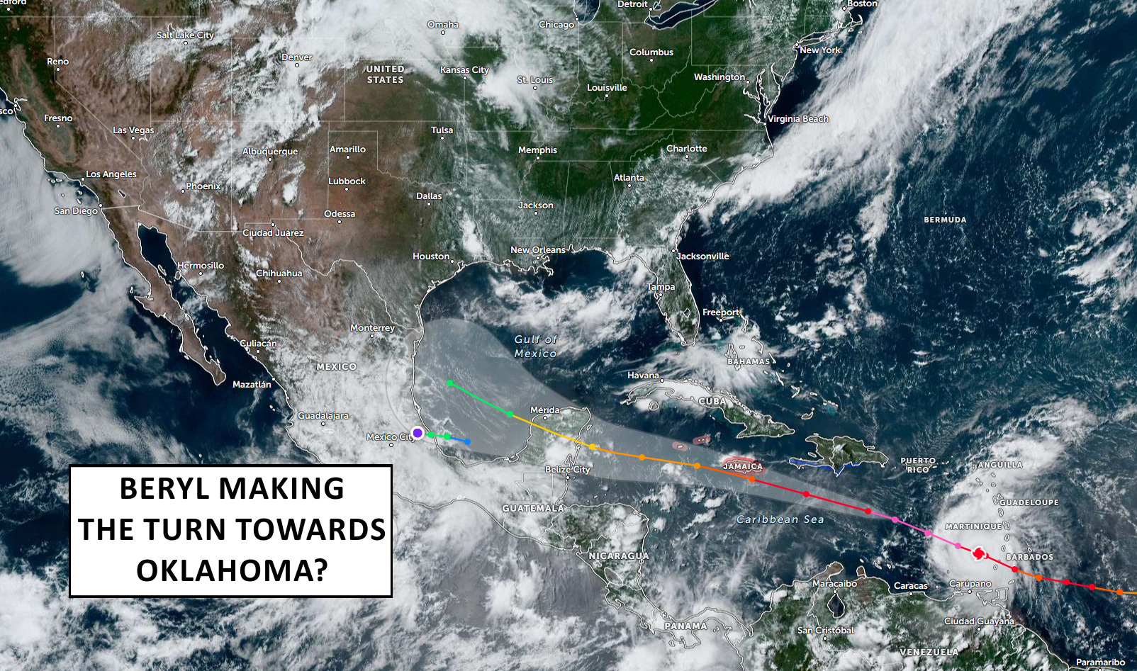
Beryling towards us?
https://ticker.mesonet.org/archive/20240702/beryl-big.png
Normally we don't care about what happens in the Tropics here in Oklahoma
weather-wise. Yes, we do get impacted by the remnants of tropical systems...it
happens. But it's still rare. And frankly (Garyly, in this case), we probably
see remnants of Pacific systems vs. Atlantic ones. But with this being predicted
a prolific Atlantic Hurricane seasons thanks to La Nina and the ultra-warmer than
normal waters in the tropics, we might have a bit more of a chance to see some
of those remnants. That brings us to Beryl, already signified as the earliest
Atlantic Cat-5 storm since accurate records began in 1850, as it "Beryls" (groaning
is acceptable) towards the Gulf of Mexico. Already starting to see signs that it
will cross the Yucatan Peninsula and then head towards the U.S. Gulf Coast is it
curves along the edge of the heat dome over the Southeastern U.S. Check out some
of the model output for farther down the road.
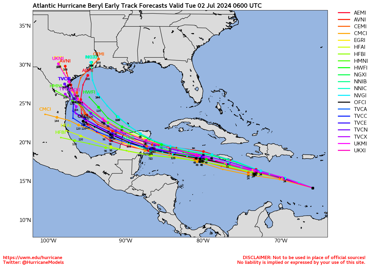
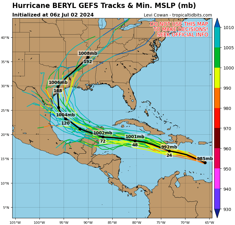
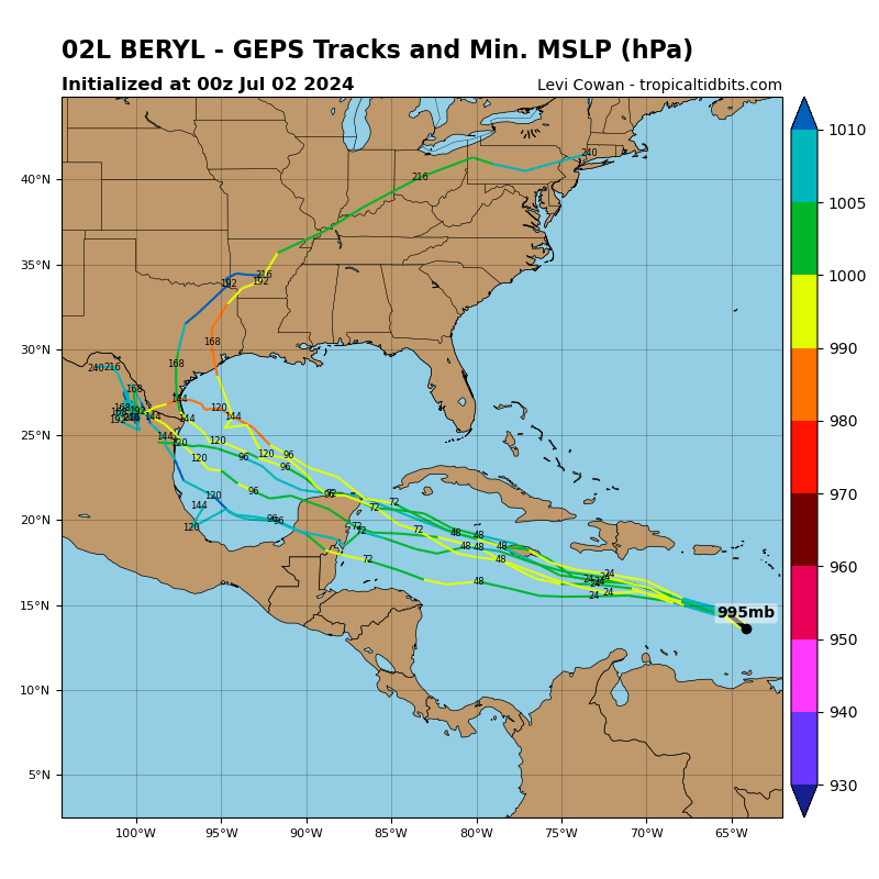
https://ticker.mesonet.org/archive/20240702/beryl.png
https://ticker.mesonet.org/archive/20240702/beryl2.png
https://ticker.mesonet.org/archive/20240702/beryl3.png
Now we're getting a bit far out to determine such fine details...remember our
oft-used "chaos forecast" post.
https://ticker.mesonet.org/archive/20221021/forecasting-chaos.png
Doesn't matter if a storm is coming from the west or east, the same laws of
physics apply...these forecasts are only as good as the initial conditions they
feed into them, and those are imperfect to say the least. But as Beryl moves
west, it can wobble and wibble (maybe even wubble and whatever other made-up
words I can think of). What if it misses the Yucatan and goes a bit north,
staying over open ocean? That would not be good news. If it goes over the
Yucatan and re-emerges on the other side, how much will it re-intensify? We've
seen plenty of instances lately where those storms rapidly strengthen in the
Gulf of Mexico.
So a lot of uncertainty as we look into next week. Remember, these storms
aren't pushed around and dominated by the steering winds...they are PART of the
steering winds, a massive heat-exchange engine whose main job is to take heat
energy from the Tropics and move it northward to satisfy Mother Nature's desire
to diminish such large-scale temperature differences. Check it out, here's how
I have viewed them ever since studying them under Dr. Sasaki in my Grad Dynamics
II class.
Heat-Exchange Engine Analogy
1. Heat Source: Hurricanes draw energy from the warm waters of the tropical
oceans. The heat from the ocean's surface warms the moist air above it,
causing the air to rise.
2. Heat Transfer: As the warm, moist air rises, it cools and condenses,
releasing latent heat. This heat release further warms the surrounding air,
causing it to rise more rapidly. This process creates a low-pressure area
at the surface and high pressure at higher altitudes, leading to the
development of strong winds as air rushes in to replace the rising air.
3. Energy Distribution: The rising air moves towards the poles at higher
altitudes, transporting heat away from the tropics. This poleward flow
helps to balance the temperature differences between the equatorial
regions and higher latitudes.
4. Cooling: Eventually, the air cools and sinks in the subtropics, losing its
moisture through precipitation and cooling as it radiates heat to space.
This sinking air creates high-pressure areas, completing the heat exchange
cycle.
Yes, this will be on the test. I'm not sure how scientifically sound the above
us, considering whose mind it came from (i.e., me!).
Now, what does it have to do with us? Well, very little UNLESS we see the
remnants, or they get close. If they go to our south and west, they can increase
the tropical moisture in our area, which means either more rain or heat index
values out of control. If it goes to our east, not much. If it moves over us,
however, it can provide energy and moisture available for lots of rain.
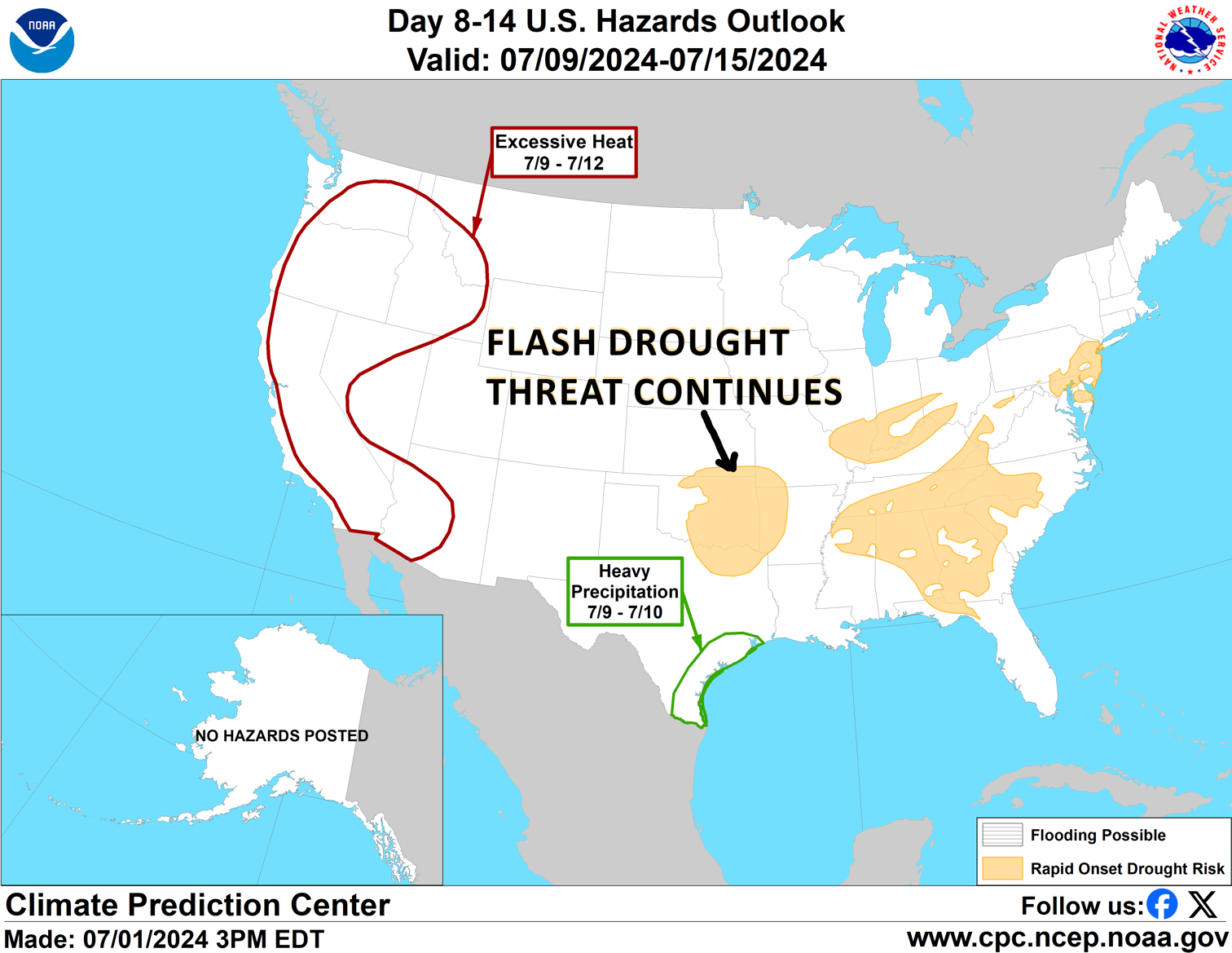
Considering we're still in flash drought mode, this could be a spoiler.
https://ticker.mesonet.org/archive/20240702/flash-drought.png
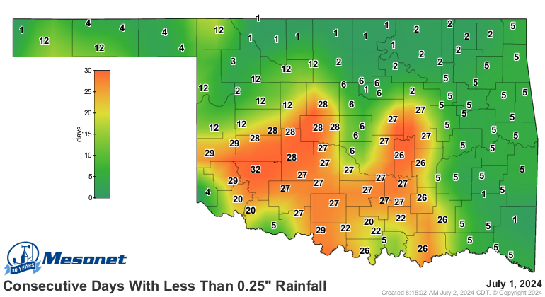
It's been awhile since some of the state has seen a good rain...wayyyy too long
in these parts as well.
https://ticker.mesonet.org/archive/20240702/mesonet.rainfall.quarterinch.png
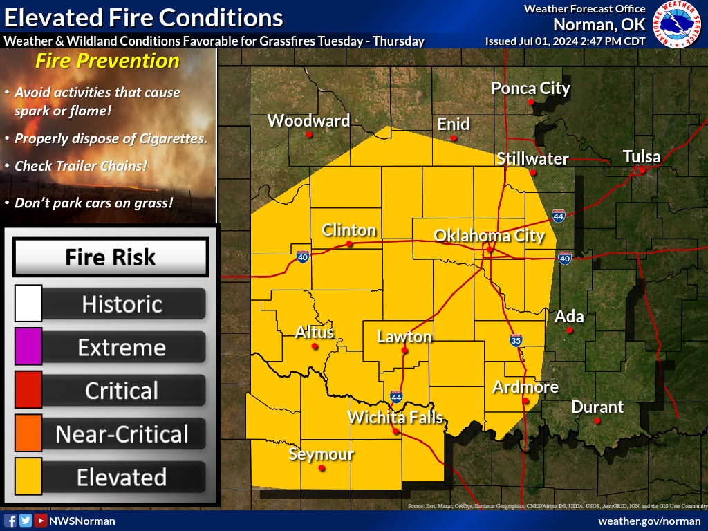
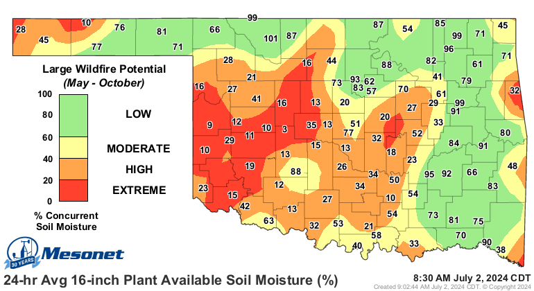
And we're already seeing significant impacts, like dwindling soil moisture
and increasing fire danger.
https://ticker.mesonet.org/archive/20240702/nws-norman-fire.png
https://ticker.mesonet.org/archive/20240702/16inch-plant-available-water-pct.png
We don't need no steenking badges...I mean tropical systems, to get some relief,
of course. Just need something to make our warm, moist air go up and form
storms. A "cold" (LOL!) front tonight will provide the focus for storms in
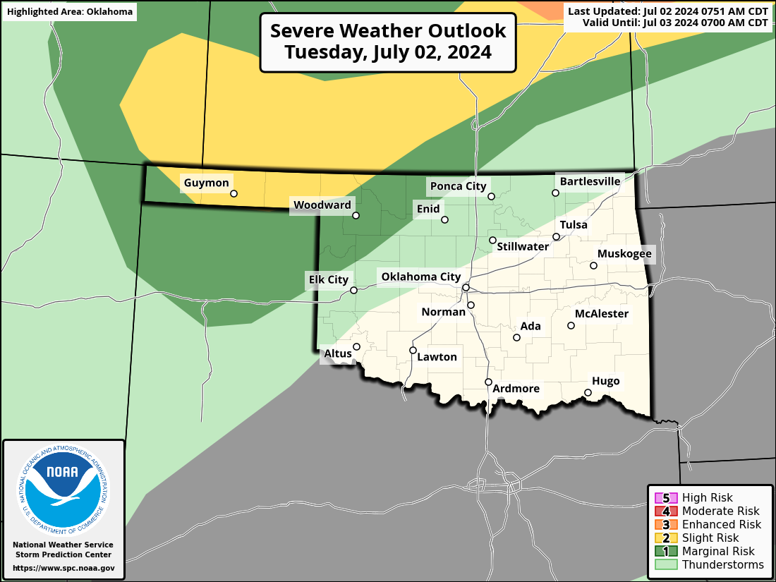
NW OK, with severe winds the main hazard.
https://ticker.mesonet.org/archive/20240702/OK_swody1.png
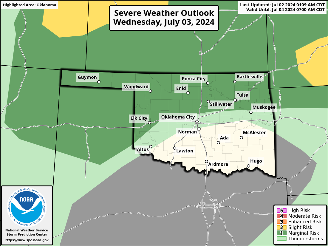
The cold front will stall over northern OK and provide a focus for storms
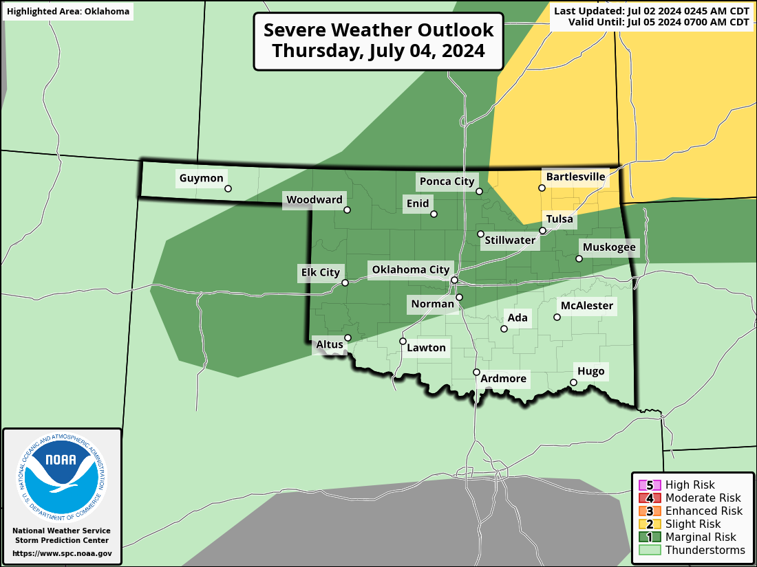
tomorrow as well before a stronger front arrives on July 4 (Not only America's
birthday, but also your favorite State Climatologist's birthday...no, not
theirs! Mine!). That front should push storms through the state during the
evening, so the fireworks displays you might be watching could be supplied by
Mother Nature.
https://ticker.mesonet.org/archive/20240702/OK_swody2.png
https://ticker.mesonet.org/archive/20240702/OK_swody3.png
Myself? I hate fireworks. No, not because of the noise or the mess, or the
mangled fingers. It's because I used to get fireworks for my birthday. Would
YOU want your birthday presents to be gone an hour later? How about something
more lasting, like a car or a yacht??
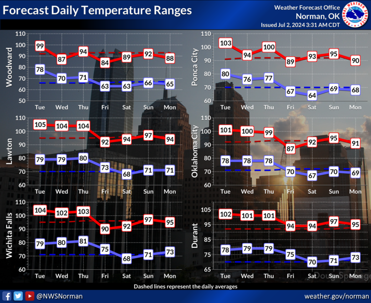
Oh well, can't have anything EXCEPT hot weather during summer in Oklahoma.
A few more scorching days before we head back to mild weather for a few days
over the weekend.
https://ticker.mesonet.org/archive/20240702/nws-norman-7day-temps.png
'Twas ever thus.
Gary McManus
State Climatologist
Oklahoma Mesonet
Oklahoma Climate Survey
gmcmanus@ou.edu
==================================================
The OCS/Mesonet Ticker
https://ticker.mesonet.org/
To subscribe or unsubscribe from the Ticker
or for questions about the Ticker or its content
Phone or Email the Ticker Manager at OCS
Phone: 405-325-2253 Email: ticker@mesonet.org
---------------------------------------------------
-C- Copyright 2024 Oklahoma Climatological Survey
===================================================
|


 Tweet
Tweet