
Ticker for September 25, 2026
MESONET TICKER ... MESONET TICKER ... MESONET TICKER ... MESONET TICKER ...
September 25, 2026 September 25, 2026 September 25, 2026 September 25, 2026
Marco...POLO!
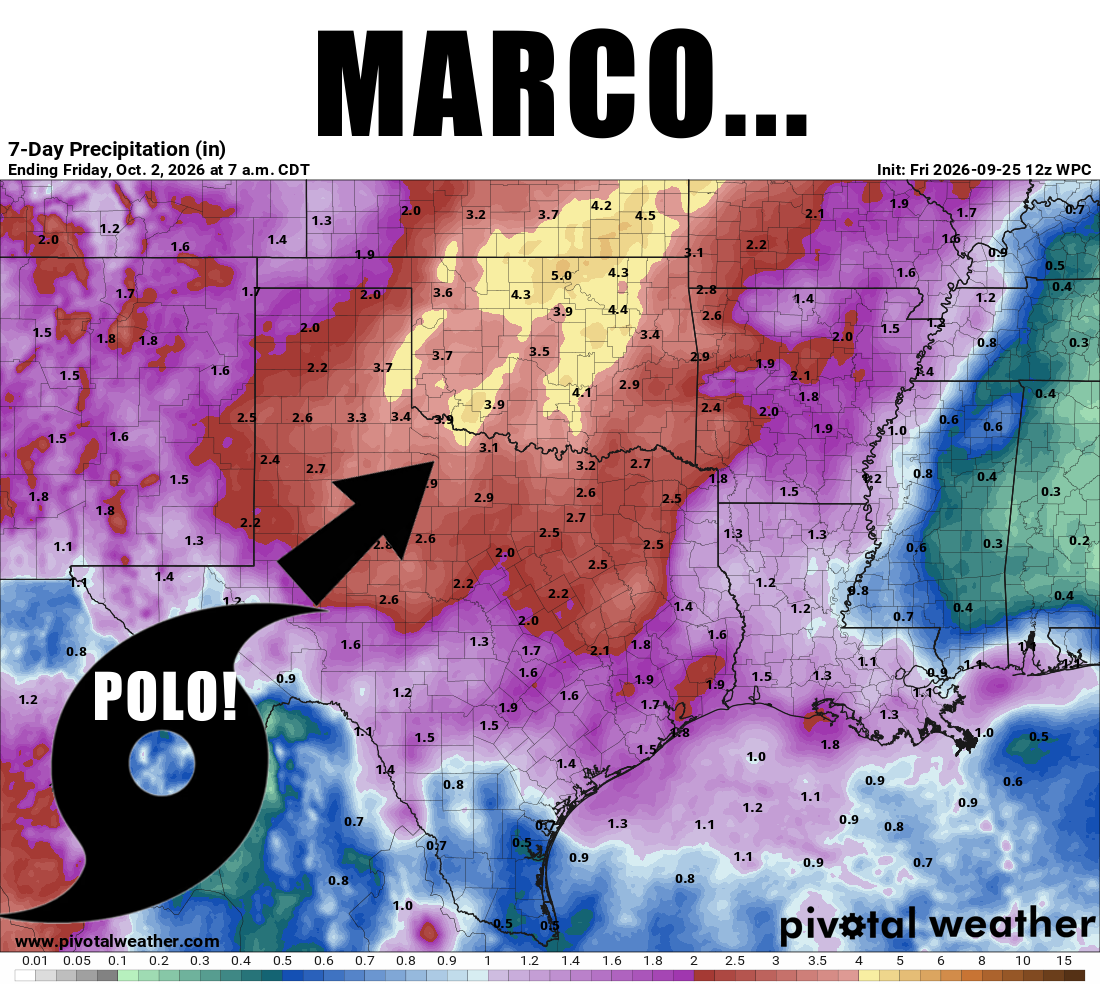
The Pacific Ocean is big, folks. So big it even makes my scalp appear
insignificant. Sure, the Atlantic gets all the pub when it comes to our weather
with remnants moving up from the Gulf into our area, but it's those Pacific
tropical system remnants that have given us some of our more historic Autumn
extreme rainfall events.
And frankly (Frank Burns eats worms, so I'll stay Gary) I've reached the point
in this drought where I’m willing to order rain from another ocean anyway. The
Gulf moisture has just been too disappointing for months.
Geography matters: the same northeastward turn that can bring a Pacific storm
TOWARDS Oklahoma can carry a Gulf storm AWAY from us. So a Pacific remnant
travels towards us from the southwest on the same steering winds that bring
those Gulf remnants towards us but quickly ushering them away to the
northeast, clipping far southeast or eastern Oklahoma before disappearing.
You still need a focusing mechanism to squeeze more moisture out of the
system. Like a cold front. A slow-moving or stalled front is even better.
And a front that has apparently signed a lease over Oklahoma, and that moisture
can keep feeding rain over the same areas. The ocean of origin matters less
than where the moisture goes, and how long the atmosphere keeps squeezing it
out, you see.
And these things tend to happen in Autumn for two very important reasons. First,
you need the tropical system, obviously, and that's almost strictly autumnal.
Second, you need the front, and we start to get those fronts again during
Autumn as the jet stream starts to find its way south again after its long
summer slumber up north.
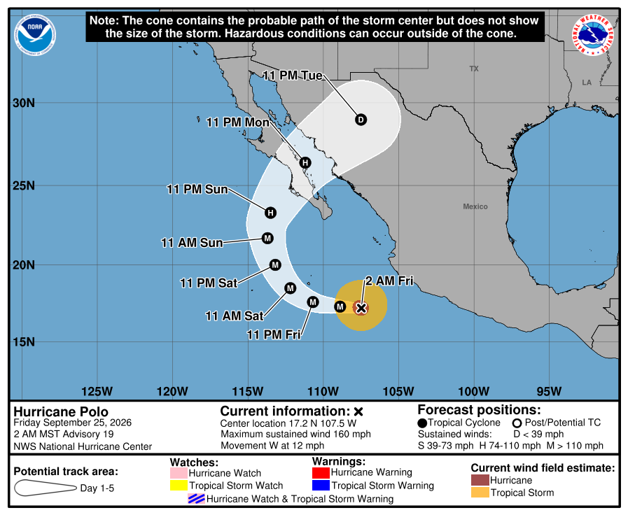
That brings us to Hurricane Polo, currently churning in the eastern Pacific.
The National Hurricane Center expects Polo to eventually turn north and
northeast toward Baja California and mainland Mexico, weakening substantially
as it crosses land. Some of its tropical moisture could then get drawn into the
storm system approaching our part of the country next week.
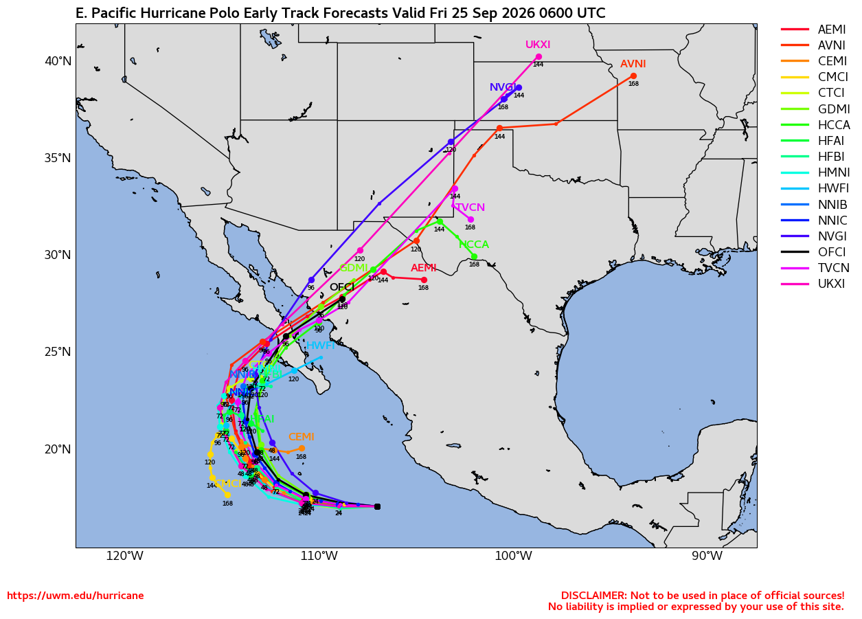
Notice the wording there: “some,” “could,” and “next week.”
Those words are doing a lot of work. Somebody get them a chair.
The opportunity is real. So are the moving parts. We have a Pacific hurricane,
a developing upper-level storm system to our west, and an approaching cold
front. Whether those ingredients produce a widespread soaking across Oklahoma
depends on how they come together.
And WHERE they come together.
And WHEN.
Now, before we get too far down the tropical rabbit hole, there’s a perfectly
reasonable question: What about all those mountains between the Pacific and
Oklahoma? Don’t they squeeze the rain out before it gets here? They certainly
take a cut. Air forced up a mountain slope cools, clouds form, and
precipitation can remove substantial moisture. That's why the lee of the Rockies
lay in what's called a "rain shadow." And the rugged terrain also disrupts the
hurricane’s circulation, while moving away from warm ocean water cuts off its
main energy supply. A powerful hurricane can unravel pretty quickly over
Mexico.
But unraveling the hurricane does not automatically dry out the atmosphere.
Tropical moisture can keep traveling long after the storm loses its identity.
Think of it as the hurricane losing its luggage but still sending the packages
ahead. Winds several miles above the ground can carry moisture across Mexico’s
high terrain and into the Southern Plains. Meanwhile, southerly winds closer to
the surface can bring in additional moisture from the Gulf thanks to an
approaching storm system and its counter-clockwise winds. That combination can
leave us with a deep layer of moist air, giving developing rain systems plenty
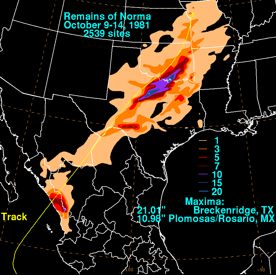
to work with. That Pacific-above, Gulf-below connection helped fuel Oklahoma
and Texas flooding during Hurricane Norma’s remnants in October 1981.
So there isn’t a universal “the mountains keep 80%, Oklahoma gets the
leftovers” rule. The track, winds, depth of the moisture and surrounding
weather pattern all matter. And having moisture overhead is only part of the
job. As I said earlier, we still need something to lift that air. That’s where
the approaching upper-level storm system and cold front enter the picture. The
upper system can help steer tropical moisture toward us and encourage rising
air over a broad area. The front can concentrate that lift as cooler, denser
air pushes beneath warmer, moist air. A front isn’t mandatory for rain, but it
can provide a particularly effective place for the atmosphere to get busy.
The hurricane’s remnants and the other low-pressure system don’t have to meet
directly over your house or field, however. The important overlap is between the
moisture and the areas where air is rising. That overlap can occur well away
from either system’s center.
Here’s how the timing can change the outcome:
*If the deepest moisture arrives while the front and upper system are providing
strong lift over Oklahoma, our chances for a substantial rain increase.
*If the front and its best lift get ahead of the tropical moisture, the biggest
rain opportunity could shift elsewhere.
*If the moisture arrives first but the stronger lift lags behind, we might
spend some time admiring clouds while waiting for the atmosphere to finish
assembling the equipment.
Aha, see how precarious this scenario is between "hey, some rain!" and "Oh no,
catastrophic flooding!"??
So if a boundary slows down while moisture keeps feeding into repeated rounds
of rain, totals can pile up over the same places. That’s how a welcome rain can
become a flooding problem.
Those are possible outcomes, not a declaration that the front will stall next
week. I'm not much for declaring anything, other than the magnificence of Wolf
Brand Chili (WITH BEANS) and Cherry Pop-Tarts.
As of Friday morning, our friends at the Norman NWS office expects rain chances
to increase Tuesday as tropical moisture begins interacting with the western
storm system. But the models disagree on how quickly that system moves east. A
faster solution brings it through around Wednesday...a slower solution keeps it
hanging back longer. Tulsa’s forecasters likewise see a growing opportunity for
widespread rain Tuesday and Wednesday, potentially lingering into Thursday.
That gives us reason for optimism. HOPE! For the first time in months. It does
not, however give us permission to start building an ark.
For a bit of historical background, let's take a look at some of the more
famous (infamous?) Pacific tropical events from our past, including the
notorious flooding associated with Norma in 1981, Tico in 1983 and Paine in 1986.
Norma
-----
We already mentioned Norma from 1981 above and showed you its rainfall map. It
was a biggie for south-central up through east-central Oklahoma, and still holds
some of our biggest 2-, 3-, 4-, 5-, 6-, and 7-day rainfall records to this day,
from 18-25 inches!
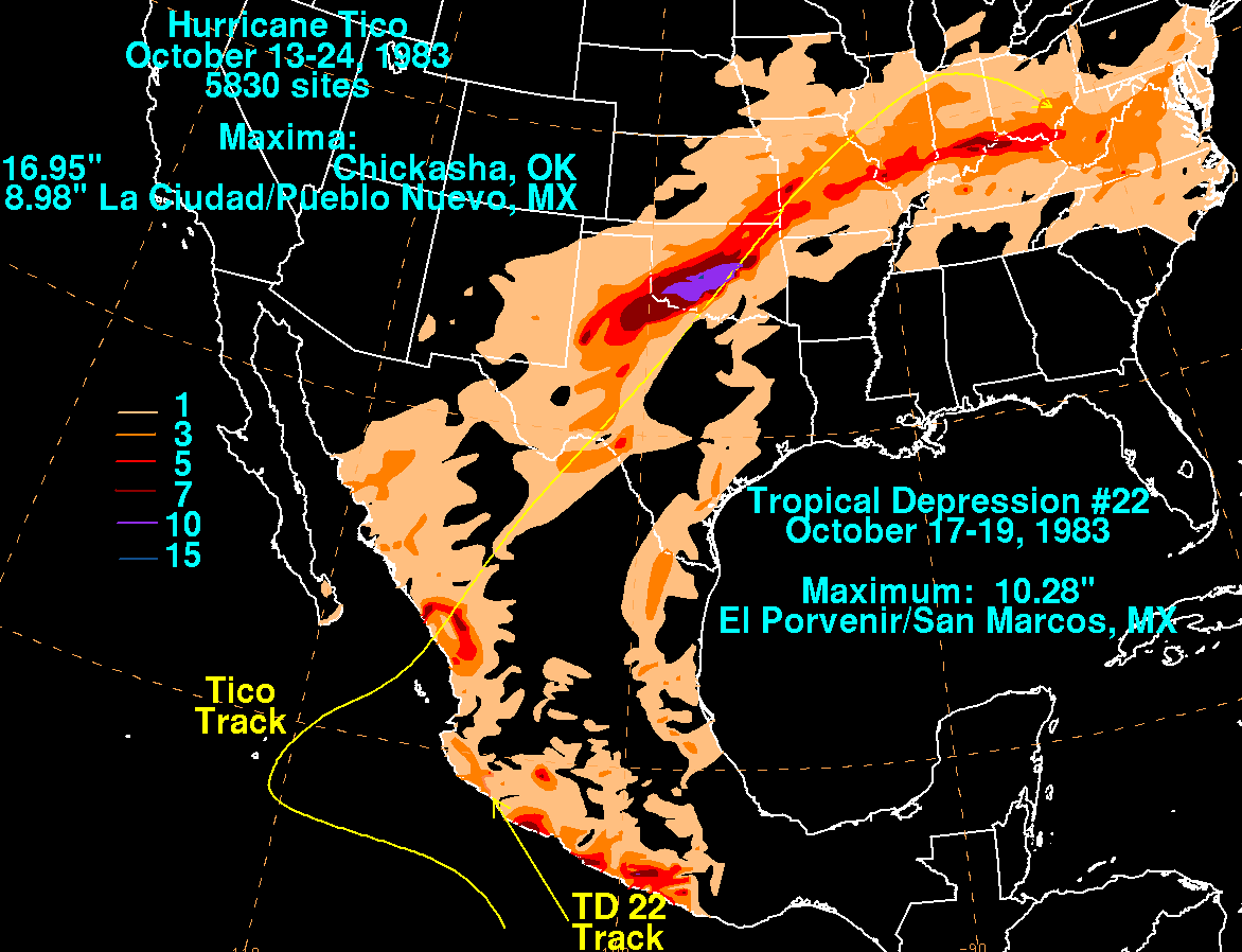
Tico
----
This was more of an I-44 corridor event that brought flooding to that region
in mid-October 1983. Not quite as significant as Norma a couple of years
earlier, but 7 inches to as many as 15 inches of rain is nothing to sneeze at.
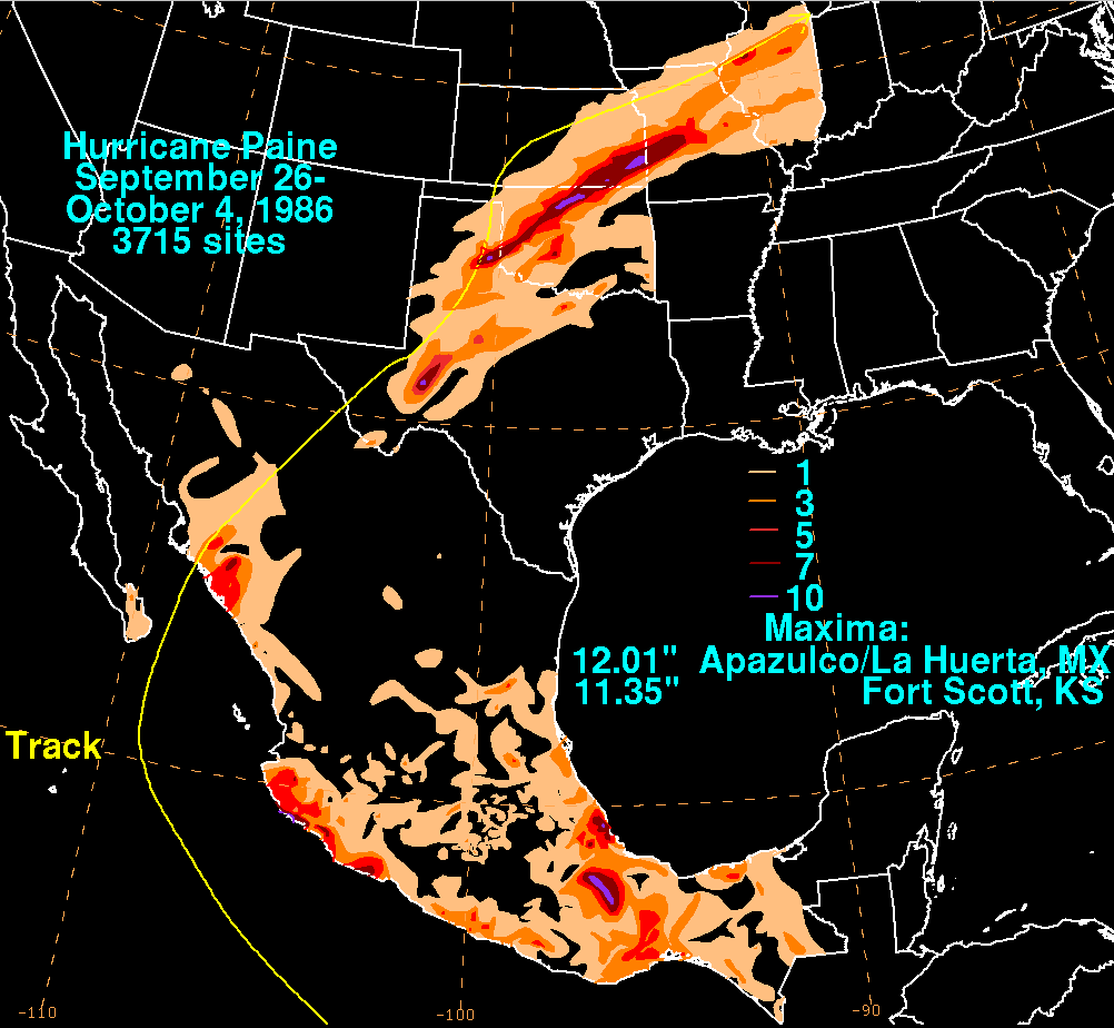
Paine
-----
An early-October event, this one hit up in northern Oklahoma with totals of 5-
10 inches and widespread flooding on the Cimarron.
Smaller but still-significant events occurred after that, including:
*Paine (Oct.1986), Waldo (Oct. 1985)
*Raymond (Oct. 1989)
*Lester (Aug. 1992)
*Ismael (Sept. 1995)
*Blanca (June 2015) Yes, June!
*Tropical Depression 19-E (Sept. 2018(
*Sergio (Oct. 2018)
*Norma (Oct. 2023) No, not THAT Norma
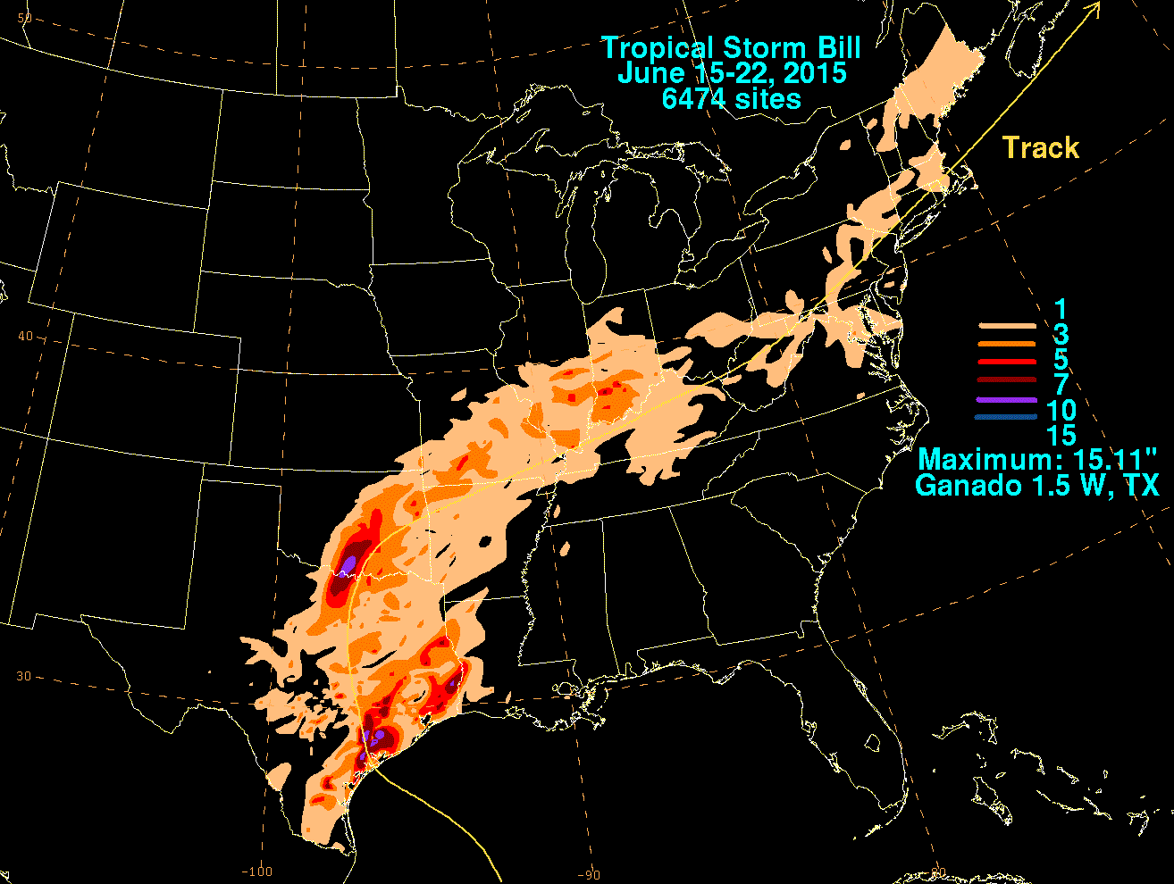
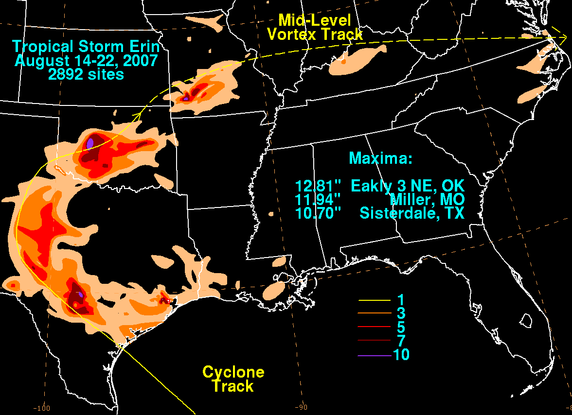
I hope I didn't give you the impression that Gulf storms are irrelevant, because
there have been some biggies, even recently...Erin in 2007 and Bill in 2015.
Well, sorta recently. Erin is one of the more famous Oklahoma weather events
in its history as an INTENSIFYING tropical system over Oklahoma that produced
locally more than 11 inches and destructive flooding. Bill brought widespread
6–12-inch amounts from the Lake Texoma area into central Oklahoma, AND it
occurred soon after Bianca from the Pacific!
But none of those Pacific events tells us how much Polo will bring to Oklahoma.
They DO show why a hurricane on the other side of Mexico belongs in our weather
conversation 4-6 days out.
For now, let's just recognize that there’s a promising opportunity for
meaningful rain next week.
Polo, you have our address. Please bring the rain!
Gary McManus
State Climatologist
Oklahoma Mesonet
Oklahoma Climate Survey
gmcmanus@ou.edu
September 25 in Mesonet History
| Record | Value | Station | Year |
|---|---|---|---|
| Maximum Temperature | 102°F | SLAP | 2020 |
| Minimum Temperature | 29°F | BOIS | 2000 |
| Maximum Rainfall | 4.95 inches | TISH | 2016 |
Mesonet records begin in 1994.
Search by Date
If you're a bit off, don't worry, because just like horseshoes, “almost” counts on the Ticker website!