
Ticker for August 3, 2026
MESONET TICKER ... MESONET TICKER ... MESONET TICKER ... MESONET TICKER ...
August 3, 2026 August 3, 2026 August 3, 2026 August 3, 2026
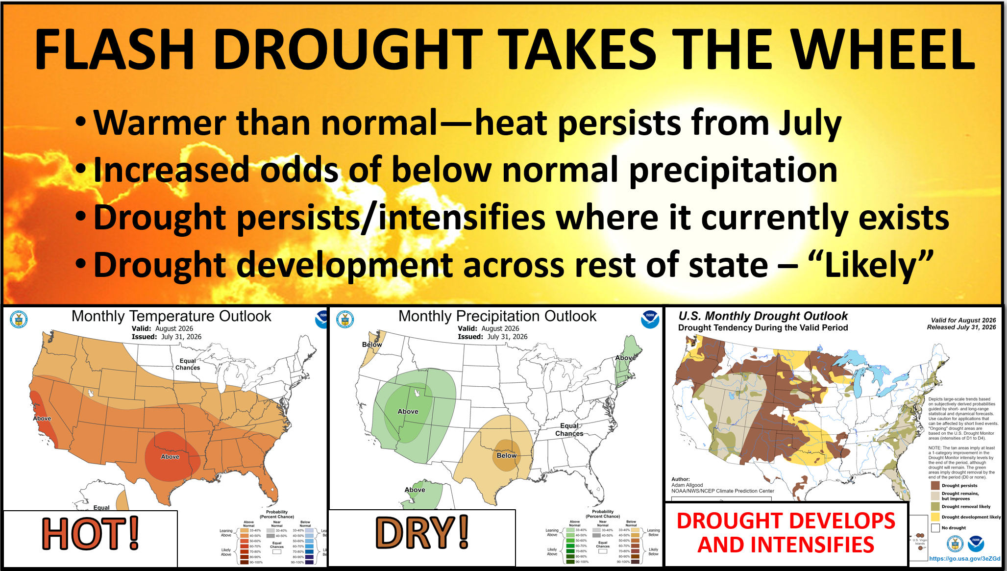
Flash drought flashes
I've been SHOUTING FROM THE ROOFTOPS (until the police were called, but at least
this time I was clothed) about not counting your El Nino chickens before they
hatched. I'm not gonna go all in-depth again, but if and when that impacts us,
it'll be later into the fall into next spring. To give a dumb-guy explainer,
there ain't a jet stream down in our area this time of year to energize and
impact, so we have to wait until it meanders back our way.
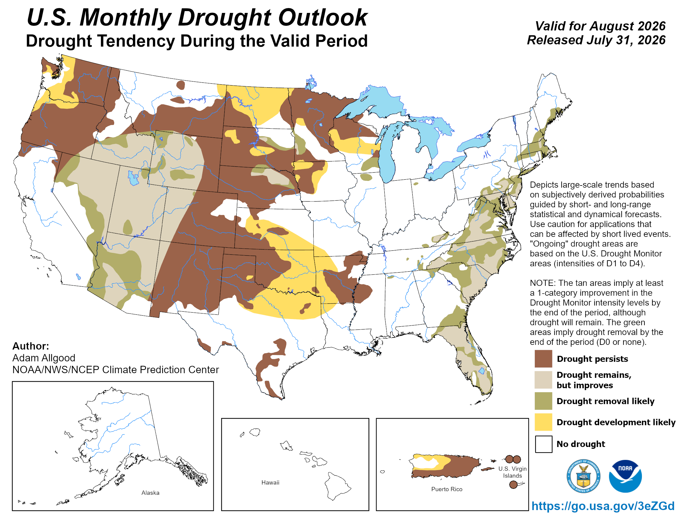
So yes, drought remains a concern, even in the next couple of weeks where CPC
has us in their dreaded "rapid onset drought risk" area. As well as heat
concerns, which is all part of the deal, of course.
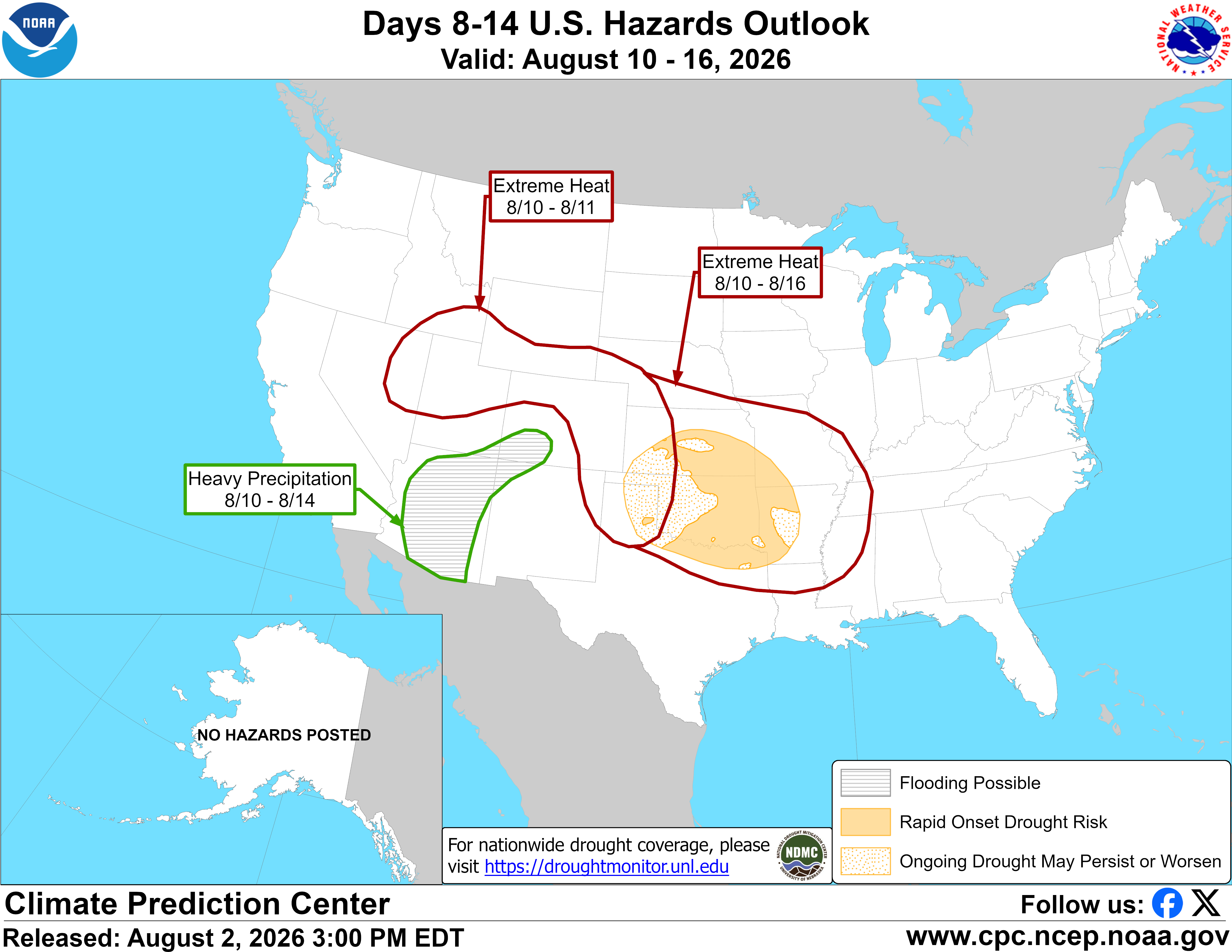
Their reasoning: "A Rapid Onset Drought (ROD) risk is designated for parts of
the Central and Southern Plains along with the Ozarks region where 30-day
precipitation deficits are greater than 2 inches and continued dryness and heat
are forecast through early to mid-August."
The weekend was lovely, I hear. Yeah, while y'all were out gallivanting around
(and we all know just how painful that can be) in your convertibles and tube
tops in the 80s and 90s weather, I was stuck inside writing the July summary.
But here comes the heat, slamming right back into us like it's August or
something.
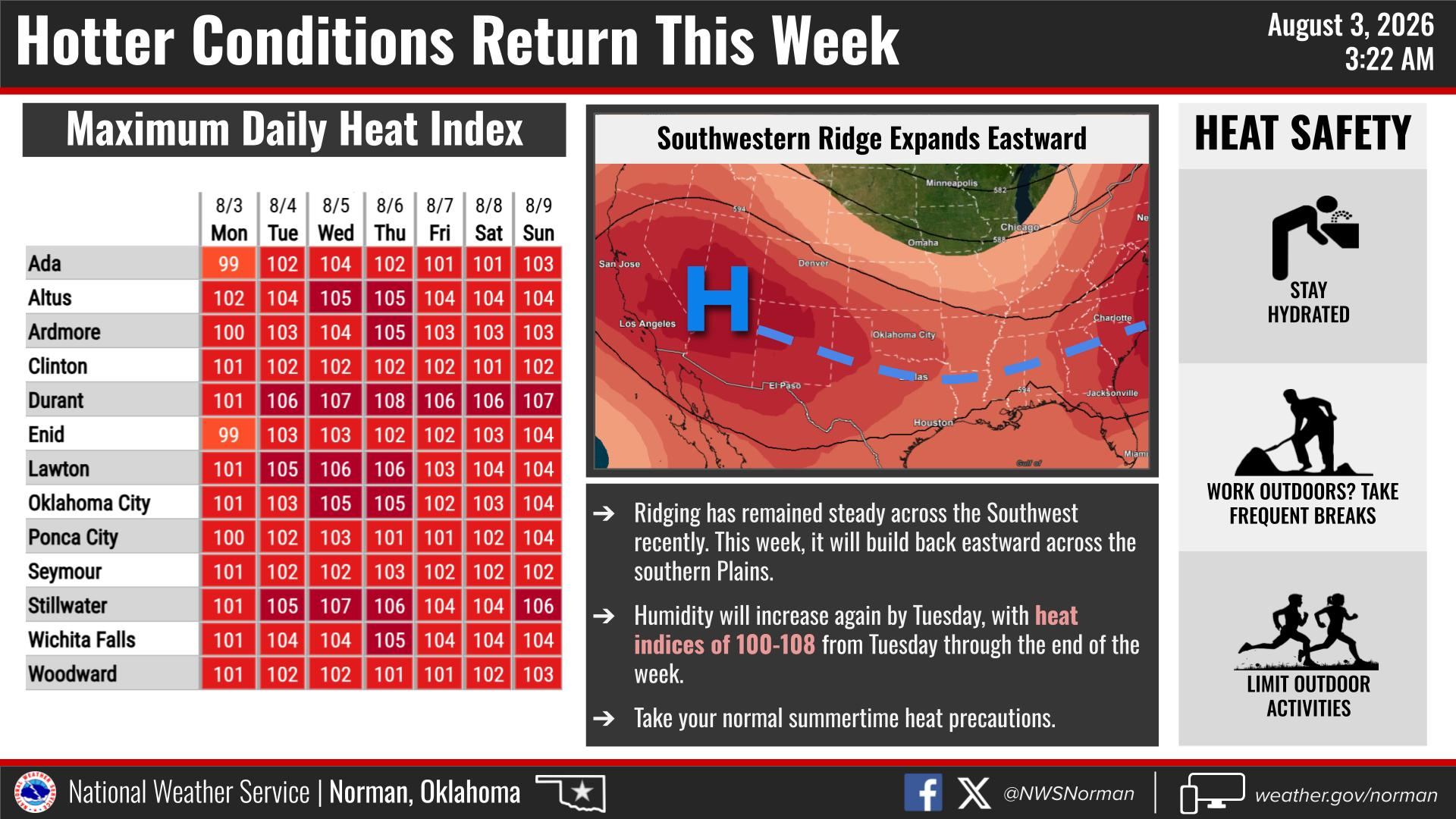
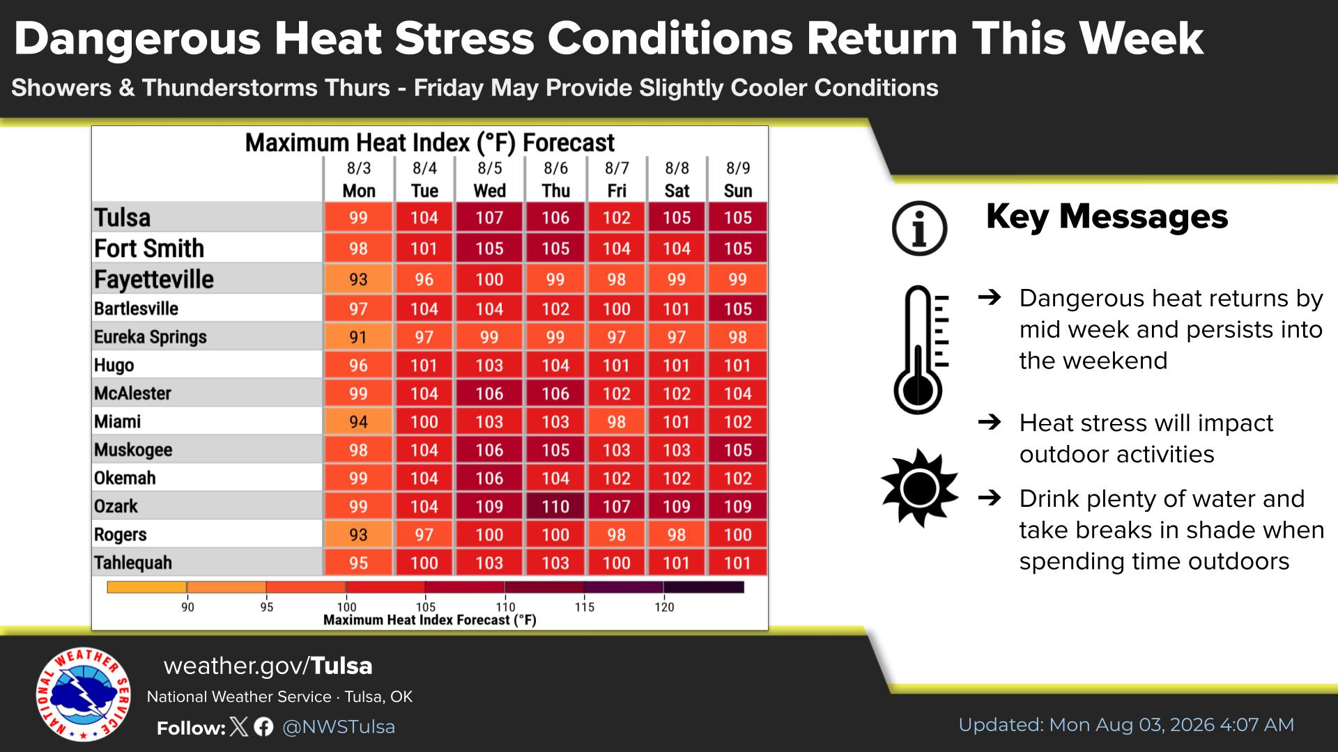
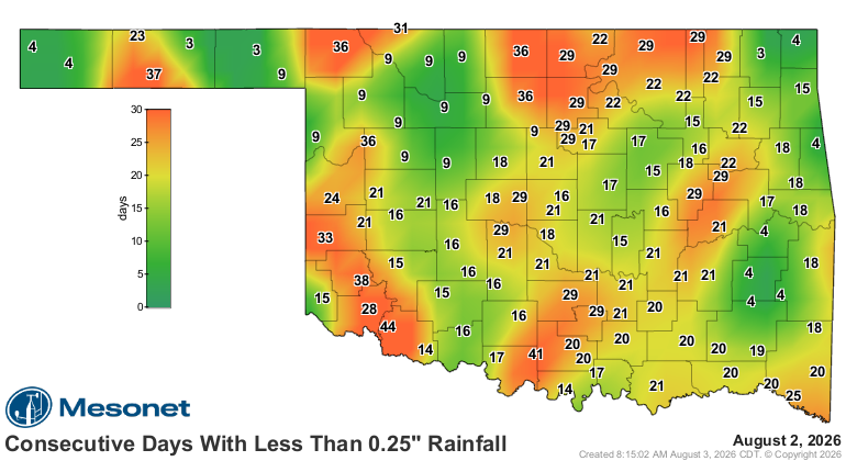
But with yet another dry spell upon us, and coming on the heels of the 20th-
warmest July on record (read below) exacerbating that dryness, flash drought
is an obvious concern, as noted above.
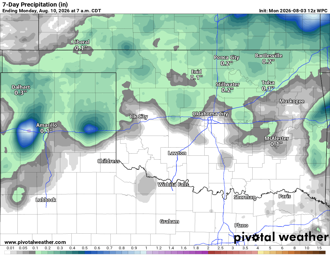
There is a rain chance coming up later in the week, but totals at this point
don't look like a game-changer.
But this isn't a game...it's Oklahoma weather. Now check out July's summary.
----------------------------------------------------------------------------------
July begins with destructive winds, ends in a heat wave
Aug. 3, 2026
Mother Nature supplied fireworks of her own on July 4 as a destructive
windstorm swept across Oklahoma, with Norman hardest hit. The month closed
under a punishing heat wave, with widespread triple-digit temperatures during
its final third. Between those dramatic bookends, rainfall fell short across
most of the state and drought coverage held nearly steady at about 44%, setting
the stage for heightened drought concerns in August.
Independence Day storms batter Oklahoma
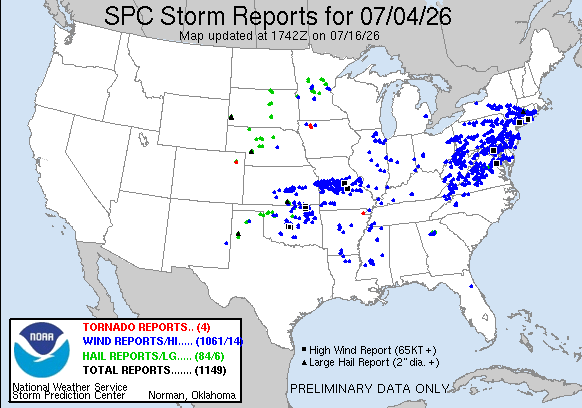
A powerful complex of thunderstorms swept through Oklahoma late on July 4,
producing widespread destructive straight-line winds. Norman took the brunt of
the storm, with measured wind gusts reaching 92 mph at Max Westheimer Airport
and 90.5 mph at the Norman Mesonet site shortly after 10 p.m. The Mesonet gust
ranked 41st on the network’s all-time list, which dates to 1994. The severity
of the damage suggested localized winds may have exceeded 100 mph. Trees were
uprooted or snapped, power poles and lines were toppled, homes and other
structures were damaged, and a tractor-trailer was blown onto its side.
Norman was not the only area hit hard. Earlier that evening, severe storms
swept across northeastern Oklahoma, damaging trees and utility infrastructure
around Tulsa, Nowata and Bartlesville. At the height of the outages,
approximately 95,000 customers were without power statewide. PSO reported a
peak of 24,522 customers without power, while OG&E and electric cooperatives
also reported widespread outages across their service territories. OG&E alone
reported 44 downed poles in Norman, while OEC reported snapped poles and
extensive damage to electric and fiber infrastructure across Cleveland County.
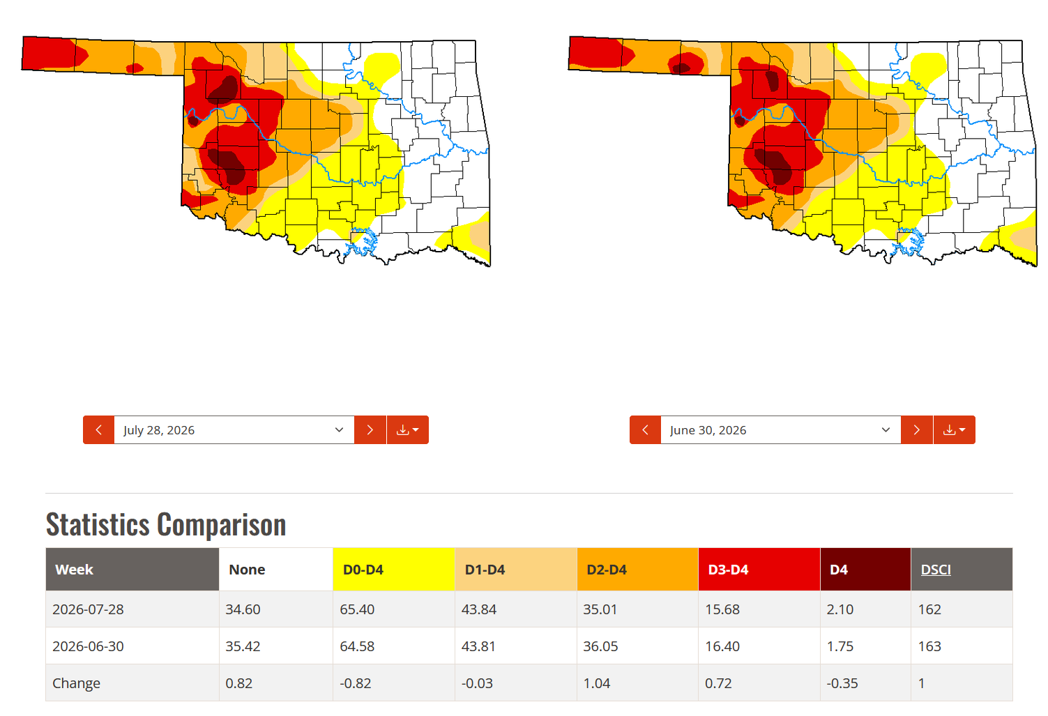
Drought coverage holds steady despite hot, dry July
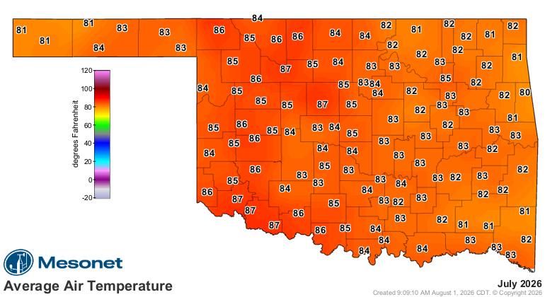
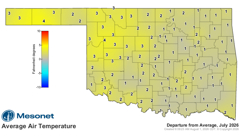
July brought widespread heat and rainfall deficits to Oklahoma. The statewide
average temperature finished at 83.9°F, 2°F above normal, ranking as the 20th-
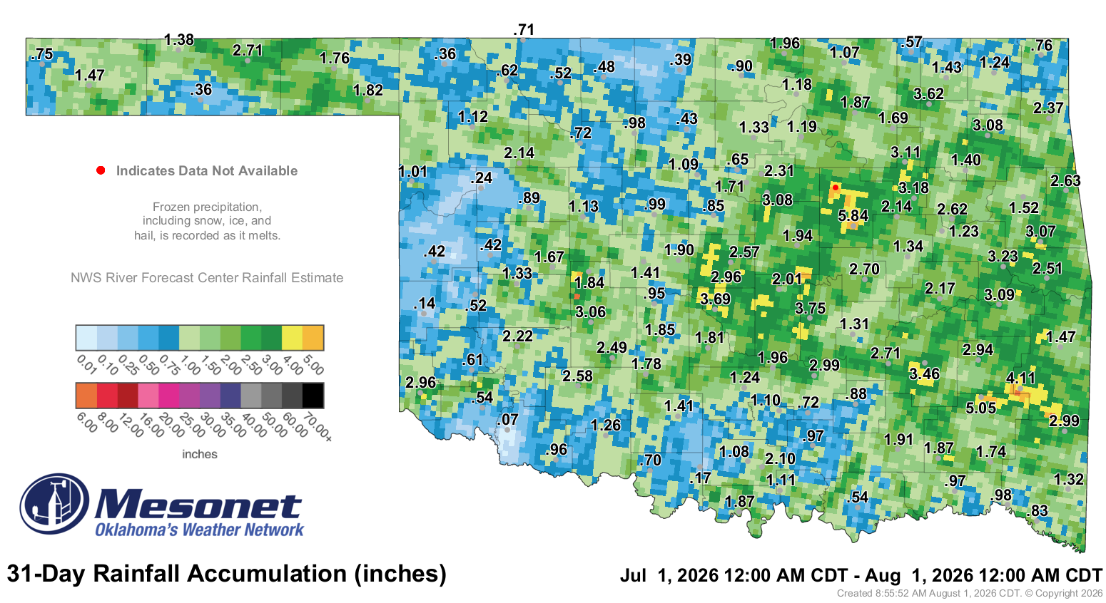
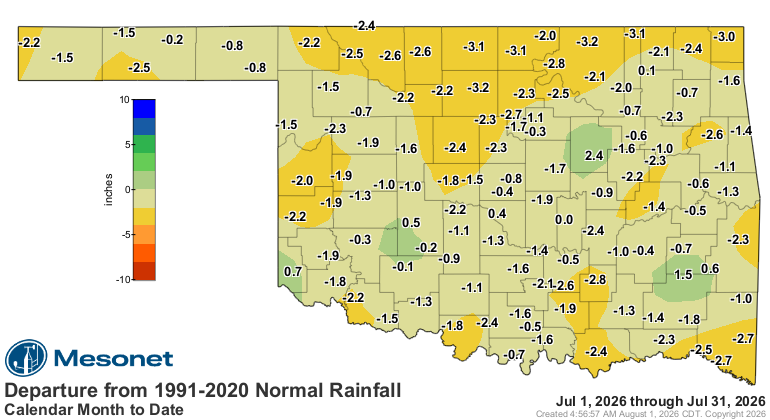
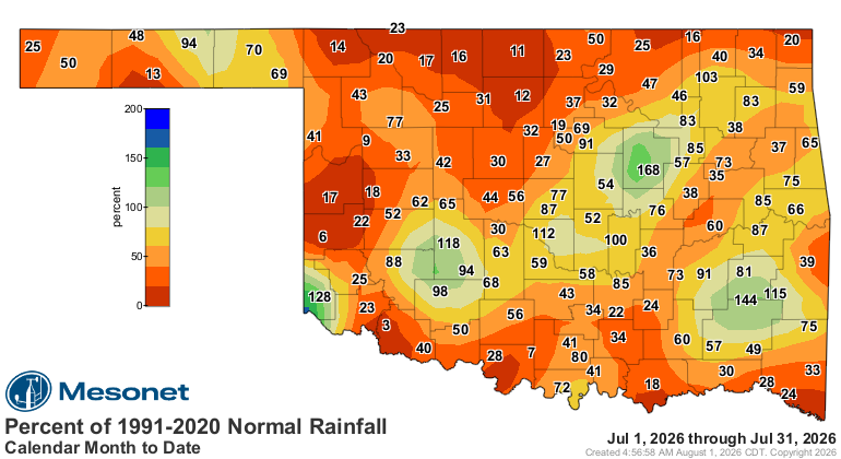
warmest July since records began in 1895. The statewide average rainfall total
was 1.64 inches, 1.56 inches below normal, ranking as the 30th-driest July on
record. Most of the state received below-normal rainfall, with the largest
deficits across western and northern Oklahoma. Scattered portions of central
and eastern Oklahoma benefited from heavier totals.
The heat became especially intense during the final third of the month, when
triple-digit temperatures spread across much of the state. On July 21,
Okmulgee’s heat index reached 125.2°F, the sixth-highest daily maximum in
Mesonet records dating to 1997. The reading resulted from an air temperature of
95.3°F and a dew point of 84.6°F, the fifth-highest dew point recorded by the
network. Six days later, Hooker reached 111°F for the month’s highest air
temperature. Despite the heat and meager rainfall, drought coverage remained
virtually unchanged at about 44%. Localized improvements and degradations
largely offset one another, leaving the statewide drought statistics in an
unusual midsummer stalemate.
July by the numbers
• Statewide average temperature: 83.9°F, 2.0°F above normal — 20th-warmest July
since 1895
• Temperature extremes: High of 111°F at Hooker on July 27; low of 57°F at Eva
on July 6
• Highest heat index: 125°F at Okmulgee on July 21
• 100-degree temperatures: 954 observations recorded at the 120 Oklahoma
Mesonet sites, including 250 at or above 105°F
• 100-degree heat index values: 2,437 readings, including 536 at or above
110°F
• Warmest and coolest locations: Highest monthly average, 87.6°F at
Grandfield; lowest, 80.0°F at Kenton
• Statewide average precipitation: 1.64 inches, 1.56 inches below normal —
30th-driest July since 1895
• Rainfall extremes: High of 5.84 inches at Bristow; low of 0.07 inches at
Tipton
• Rainfall totals 2 inches or less: 82 sites, including 37 at or below 1 inch
August outlook raises flash drought concerns
The Climate Prediction Center’s August outlook favors above-normal temperatures
across Oklahoma and below-normal precipitation across much of the Southern
Plains, a combination that raises the threat of rapidly worsening drought
conditions. CPC’s monthly drought outlook calls for drought to persist where it
already exists and for rapid drought development across all areas of Oklahoma
not already in drought, citing growing 30- to 60-day rainfall deficits and
rapidly declining soil moisture. The concern extends into mid-August, with
CPC’s Week 2 hazards outlook highlighting parts of Oklahoma and the surrounding
Southern Plains for rapid-onset drought as continued heat and dryness increase
evaporative demand.
###
Gary McManus
State Climatologist
Oklahoma Mesonet
Oklahoma Climate Survey
gmcmanus@ou.edu
August 3 in Mesonet History
| Record | Value | Station | Year |
|---|---|---|---|
| Maximum Temperature | 115°F | WILB | 2011 |
| Minimum Temperature | 53°F | CAMA | 2021 |
| Maximum Rainfall | 5.73 inches | CHER | 1995 |
Mesonet records begin in 1994.
Search by Date
If you're a bit off, don't worry, because just like horseshoes, “almost” counts on the Ticker website!