
Ticker for July 1, 2026
MESONET TICKER ... MESONET TICKER ... MESONET TICKER ... MESONET TICKER ...
July 1, 2026 July 1, 2026 July 1, 2026 July 1, 2026
Whoosh!
It's okay to be disappointed. For example, I try to think but nothing happens.
That's disappointing.
So is my long-term outlook on hair.
Sad, really.
Also, as I've talked about before after growing up watching TV in the 70s and
80s, I thought I'd have more encounters with quicksand, evil Tiki idols from
Hawaii, and lots of weird misunderstandings with my two roommates out in Malibu.
What a ripoff.
And what about all the hundreds of people a year I should have seen slipping on
banana peels?
A crock, I tell ya!
But that list above is definitely NOT something you should be disappointed about
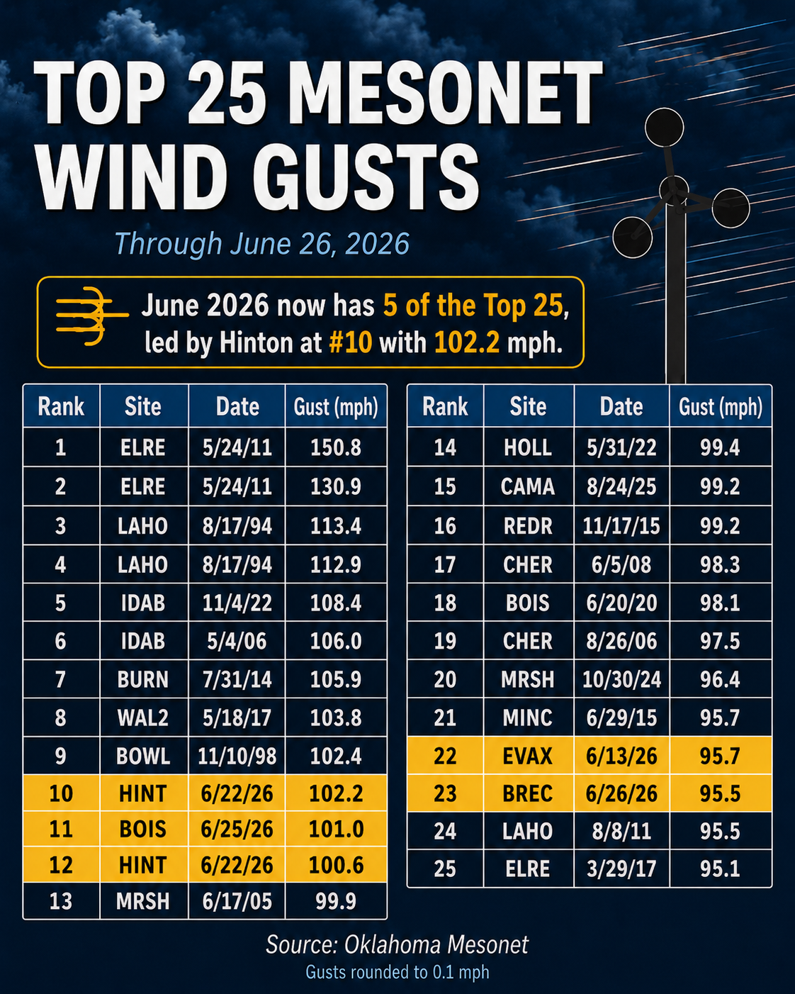
if your local Mesonet site has never made the list. Are you kidding me, June
2026?? Five of the Mesonet's top-25 all-time wind gusts? And make it six of the
top-50 if you throw in Freedom's 88.7 mph gust on the 22nd. Ain't no other
month on there even close to that many. Heck, there isn't even a YEAR with
that many in the top-25 for crying out loud!
Well, with that excitement abated (English to Okie translation: over), we now
turn to our regularly scheduled summer doldrums.
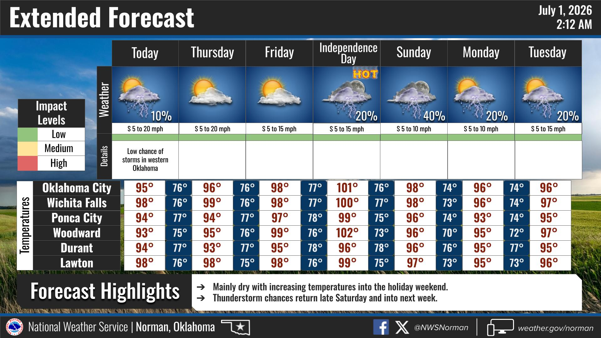
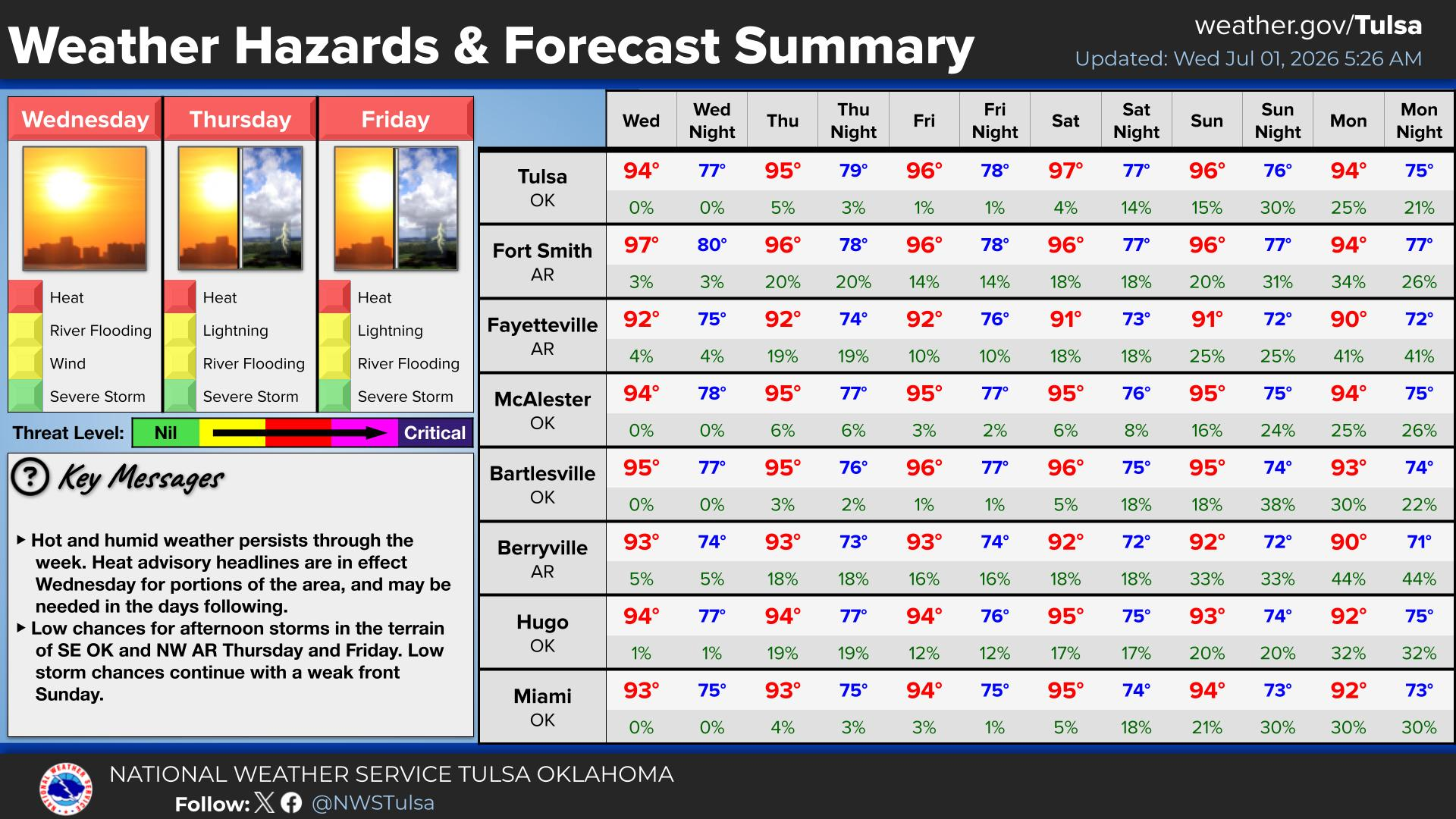
Kinda hot. Kinda humid. A chance of rain here and there later in the week into
next week.
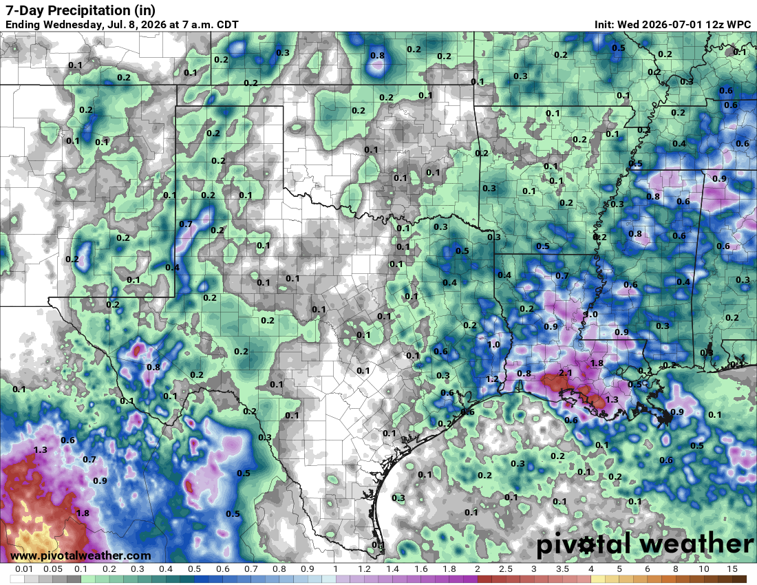
It'll probably get exciting again soon, but don't be disappointed if it doesn't.
Now onto a look back at June.
----------------------------------------------------------------------------------
June brings historic winds and uneven drought relief
July 1, 2026
June’s severe weather story was not led by tornadoes, but by straight-line
winds. A powerful derecho and several other intense storm events produced six
of the Oklahoma Mesonet’s top 50 all-time wind gusts during the month, including
three triple-digit readings.
June also brought a much-needed rainfall rebound, finishing as the 16th-wettest
June since records began in 1895. That rain helped cut statewide drought
coverage from 81% to 53%, but the relief was uneven. The worst drought
conditions remained from west-central Oklahoma into the Panhandle, even as much
of the eastern two-thirds of the state improved.
Straight-line winds dominate June severe weather
------------------------------------------------
Straight-line winds dominated June severe weather, producing six of the
Oklahoma Mesonet’s top 50 all-time wind gusts during the month — the most for
any single month since the network was commissioned in January 1994.
The most widespread damage came June 21–22, when a powerful derecho swept
across Oklahoma from northwest to southeast. The long-lived, widespread
damaging windstorm produced two triple-digit wind gusts at the Hinton Mesonet
site, reaching 102 mph and 101 mph, with several other locations recording
gusts in the 80s. The Mesonet recorded 54 severe wind gusts of at least 58 mph
during the event, including 20 gusts of at least 70 mph and eight of at least
80 mph. The widespread winds damaged trees, power lines, homes and farm
infrastructure, knocked out power to tens of thousands of customers, and
contributed to a BNSF train derailment near Woodward that affected both main
tracks. The damage path extended from the High Plains of Kansas to southwestern
Arkansas.
June’s historic wind gusts were not limited to the derecho. A June 25 severe
storm in the Oklahoma Panhandle produced a 101 mph gust at Boise City, while
Eva recorded a 96 mph gust on June 13 and Breckinridge recorded a 96 mph gust
on June 26. The Hinton, Boise City, Eva and Breckinridge gusts all ranked among
the Mesonet’s top 25 all-time wind gusts.
The two Hinton gusts ranked as the 10th and 12th strongest measured by the
Mesonet, while the Boise City gust ranked 11th. The Eva and Breckinridge gusts
ranked 22nd and 23rd, respectively, and an 89 mph gust at Freedom during the
derecho ranked 50th. The all-time list is topped by the 151 mph gust at El Reno
during a close encounter with an EF5 tornado on May 24, 2011.
June rains bring drought relief, but not everywhere
---------------------------------------------------
The statewide average rainfall total finished at 6.68 inches, 2.42 inches above
normal, ranking as the 16th-wettest June since records began in 1895. Rainfall
totals ranged from a high of 16.01 inches at Idabel to 1.40 inches at Goodwell.
Sixty-two of the Mesonet’s 120 sites recorded at least 6 inches of rain, and 19
of those sites had at least 10 inches. More than 40 Mesonet sites finished at
least 2 inches above normal for June, with about 20 exceeding 4 inches and
roughly a dozen topping 6 inches. Idabel led the state with a surplus of 11.9
inches.
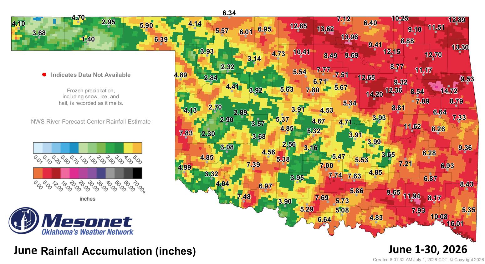
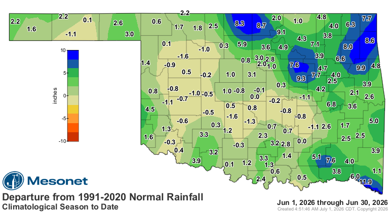
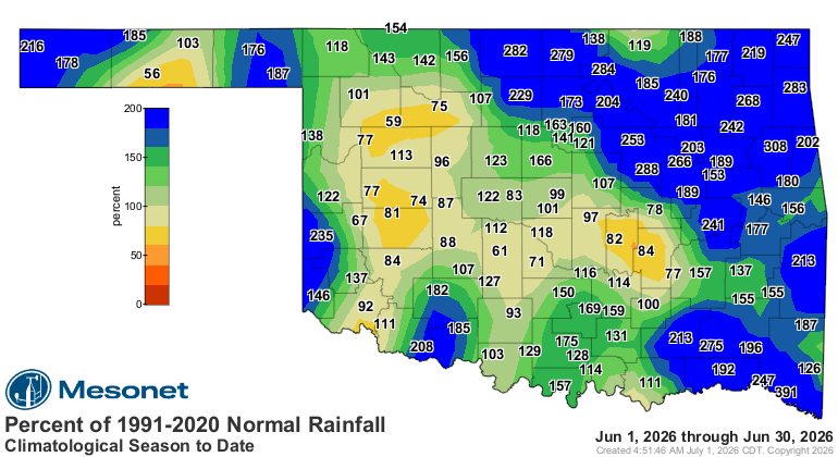
The wet pattern was not universal, however. A concentrated area of deficits
stretched from west-central into southwestern Oklahoma and south of the
Oklahoma City metro area. Those deficits were generally around a half-inch to
an inch, although a few sites exceeded the inch mark.
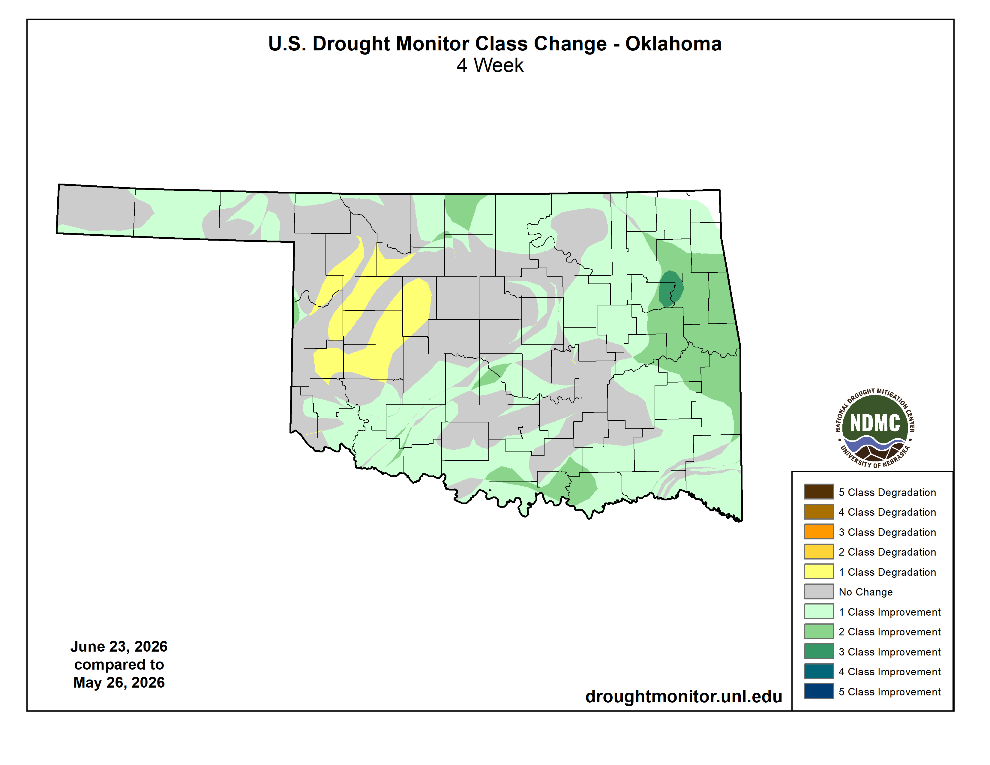
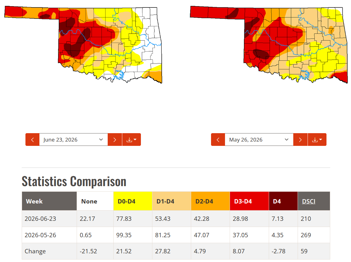
The abundant rainfall brought significant drought relief to the eastern
two-thirds of the state, with drought coverage dropping from 81% of Oklahoma on
May 26 to 53% on June 23, according to the U.S. Drought Monitor. Severe-to-
exceptional drought also declined from 47% to 42%, while extreme-to-exceptional
drought fell from 37% to 29%. The worst conditions remained from west-central
and central Oklahoma northwestward into the Panhandle, however, and exceptional
drought increased from 4% to 7% of the state.
June by the numbers
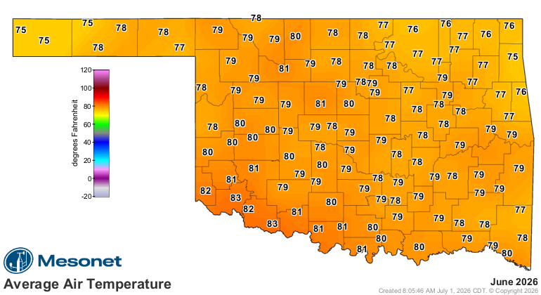
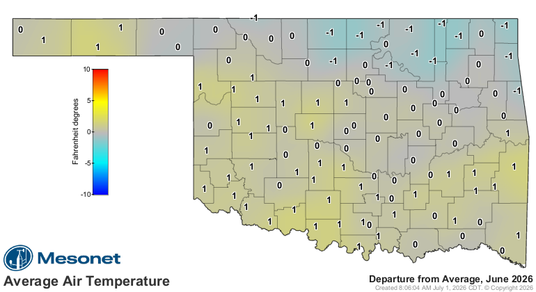
• Statewide average temperature: 79.1°F, 1.8°F above normal — 27th-warmest
June since 1895
• Temperature extremes: High of 107°F at Hollis on June 17; low of 51°F at
Eva and Kenton on June 12
• Highest heat index: 113°F at Cherokee and Fairview on June 8
• 100-degree temperatures: 95 observations recorded at the 120 Oklahoma
Mesonet sites
• 100-degree heat index values: 1,340 observations, including 334 at or
above 105°F
• Warmest and coolest locations: Highest monthly average, 83.3°F at
Grandfield; lowest, 74.4°F at Kenton
• Statewide average precipitation: 6.68 inches, 2.42 inches above
normal — 16th-wettest June since 1895
• Rainfall extremes: High of 16.01 inches at Idabel; low of 1.40 inches
at Goodwell
• Rainfall totals of 5 inches or more: 78 Mesonet sites, including 35
at or above 8 inches and 19 at or above 10 inches
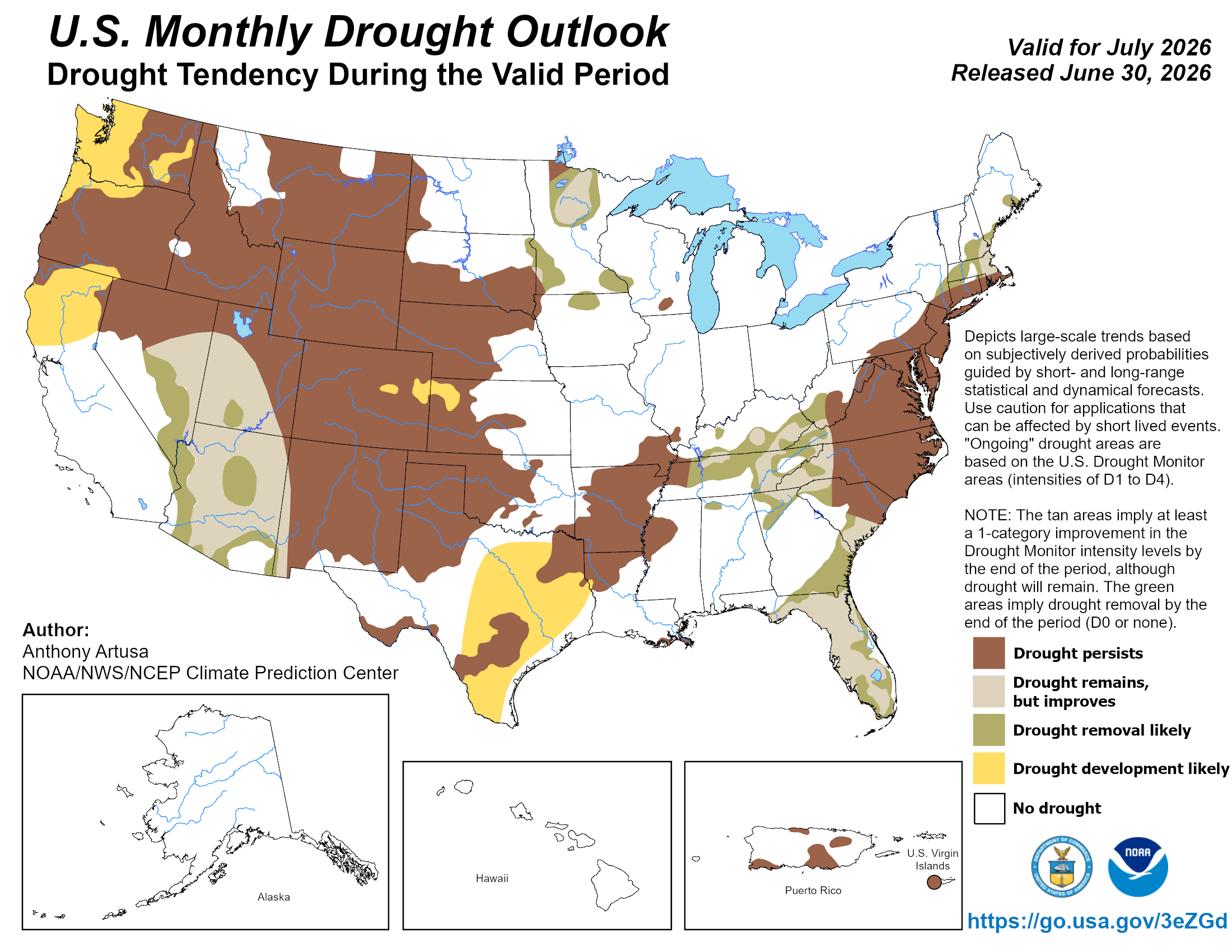
July outlook favors heat, western drought persistence
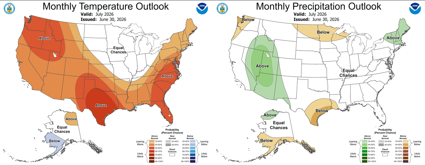
The Climate Prediction Center’s July outlook favors above-normal temperatures
across Oklahoma, while the precipitation outlook shows equal chances of above-,
below- or near-normal rainfall statewide. That leaves drought recovery
uncertain heading deeper into summer. The monthly drought outlook keeps
drought in place across much of western Oklahoma, including the Panhandle and
west-central areas where the worst conditions remained at the end of June.
Farther east, where June rainfall brought widespread improvement and drought
removal, the outlook shows little additional drought concern.
###
Gary McManus
State Climatologist
Oklahoma Mesonet
Oklahoma Climate Survey
gmcmanus@ou.edu
July 1 in Mesonet History
| Record | Value | Station | Year |
|---|---|---|---|
| Maximum Temperature | 110°F | ALVA | 1997 |
| Minimum Temperature | 50°F | EVAX | 2017 |
| Maximum Rainfall | 5.82 inches | PAWN | 2016 |
Mesonet records begin in 1994.
Search by Date
If you're a bit off, don't worry, because just like horseshoes, “almost” counts on the Ticker website!