Ticker for April 1, 2026
MESONET TICKER ... MESONET TICKER ... MESONET TICKER ... MESONET TICKER ...
April 1, 2026 April 1, 2026 April 1, 2026 April 1, 2026
Don't be a fool, be weather aware!
Hey, didya know that this March was the warmest in state history? And that we
also set a record number of tornadoes for March (20)?
APRIL FOOLS!
No, wait...that really did happen.
Okay, here's one: didya know that every multi-month period backwards from March
to July (i.e., February-March, January-March, December-March...July-March) was
also the warmest on record?
APRIL FOOLS!
Well, no fooling again. That's also true.
The April Fools jokes aren't working. Here's one: What do you call the rain
that fell the last couple of days in far SW OK, and also a bus full of State
Climatologists at the bottom of the ocean?
A good start!!
HAHAHAHAHAHAHAHA
HAHAHAHA
HAHA
HA
ha
Oh. Well, I thought it was funny.

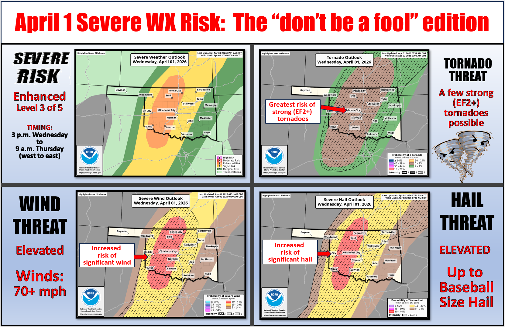
But to get serious for a moment, we really (okay, moment over...starting
another) need to be weather aware today. You should have your severe weather
plan in place, given that we've already had 25 tornadoes this year, including
the record March number, as well as horrible hailstorms. And the worst statistic
of all...4 deaths from tornadoes this year already, and all occurred in the
worst places you can be during a tornado...a manufactured home and a vehicle.
Here's a detailed list of things you can do to keep you and your loved
ones safe today in the face of possible significant severe weather:
1. Stay Weather Aware All Day
Monitor reliable sources like your local National Weather Service
office, TV meteorologists, NOAA Weather Radio, or weather apps.
Don’t rely solely on outdoor sirens — they’re not designed to be heard
indoors.
2. Know Your Risk Areas
Stay especially alert if you live in central, eastern, or northeastern
Oklahoma, where the highest threat exists today.
Check if your county is under a Tornado Watch or Severe Thunderstorm
Watch — these may be issued before storms begin.
3. Have Multiple Ways to Get Alerts
Make sure Wireless Emergency Alerts (WEA) are enabled on your phone.
Have a NOAA Weather Radio as a backup.
Follow your local emergency management on social media for real-time
updates.
4. Review Your Tornado Safety Plan
Know where your safe place is: a storm shelter, basement, or small
interior room on the lowest floor, away from windows.
If you live in a mobile home or temporary structure, have a plan to get
to a sturdier building quickly.
5. Prepare Your Emergency Kit
Flashlight, batteries, phone charger (and backup battery), water,
snacks, shoes, weather radio, medications, ID, and important documents.
Include helmets (bike or sports helmets) for everyone in the household
if tornadoes are expected.
6. Keep Vehicles Fueled and Phones Charged
Power outages are possible from damaging winds or tornadoes.
7. Stay Off the Roads During Warnings
Don’t try to “outrun” a tornado. Shelter in place unless you’re
evacuating a mobile home to a safer location.
If caught outside or in a car with no other options, try to get to a
ditch or low-lying area and cover your head, but this is a last resort.
8 Check In With Family and Neighbors
Especially those who are elderly or have mobility issues — make sure
they know the forecast and have a plan.
9. Stay Calm, Take Action
Don’t panic — if you’ve prepared ahead of time, you’ll be in the best
position to protect yourself and your loved ones.
At the least, let's hope for some beneficial rainfall. We'll stick to the current
system, for starters.
Now, onto backwards to go back and see March as we go back and look at what
happened back then. Confused?
Welcome to my world.
----------------------------------------------------------------------------------
Record warmth, tornadoes highlight historic March
April 1, 2026
Oklahoma seemingly took a detour from February straight into July during what
became the warmest March on record for the state. The unusual heat arrived on
the heels of both the warmest winter and February on record. The records didn’t
stop there, as the state also experienced its highest March temperature on
record and a record number of tornadoes. The heat combined with dry and windy
conditions to intensify the state’s ongoing drought and elevate wildfire danger.
Record warmth shatters March temperature marks
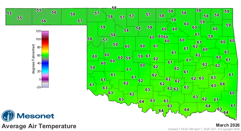
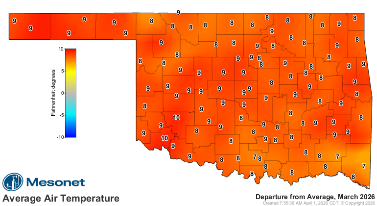
Oklahoma’s statewide average temperature finished at 60.3 degrees in March, 9.1
degrees above normal and the warmest March since records began in 1895. The
previous record of 59.6 degrees was set in 2012. March also helped drive the
warmest first three months of the year on record, with a January–March average
of 49.5 degrees, 5.5 degrees above normal. The sustained warmth extends even
further back, with the July 2025–March 2026 period ranking as the warmest on
record at 4.1 degrees above normal, part of a broader stretch of record warmth
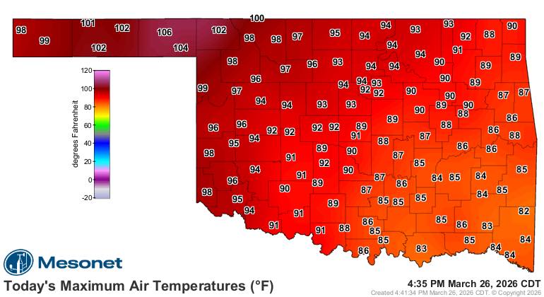
over the past nine months. Oklahoma’s first triple-digit temperatures of 2026
arrived early, on March 20, when Altus, Elk City, Hollis and Mangum reached at
least 100 degrees. The heat peaked on March 26 when the Oklahoma Mesonet site
at Beaver reached 106 degrees, the highest temperature ever recorded in
Oklahoma during March, surpassing the previous record of 104 degrees set at
Frederick on March 27, 1971. In all, there were 478 readings of at least 90
degrees across the 120 Mesonet sites during March, including 14 readings at or
above 100 degrees.

March tornado count sets record
Oklahoma recorded a preliminary total of 20 tornadoes during March, according
to the National Weather Service, surpassing the previous record of 17 set in
1991. That brings the year-to-date total to 25 tornadoes, well above the long-
term averages of 4 for March and 5.2 for January through March (1950–2025).
Eighteen of the 20 tornadoes occurred during a concentrated outbreak on March
5–6. The most significant storm was an EF3 tornado that struck near Beggs in
Okmulgee County on the evening of March 6, heavily damaging the middle and high
school complexes and destroying multiple homes and businesses. The tornado
killed two people and injured two others as it tracked 6.8 miles with a maximum
width of 950 yards. Another deadly tornado occurred on March 5 near Fairview,
where an EF2 tornado struck a vehicle along U.S. Highway 60, killing two
occupants. An additional EF2 tornado near Glover in McCurtain County destroyed
a residence and injured one person. Two other EF2 tornadoes were also confirmed
during the month.
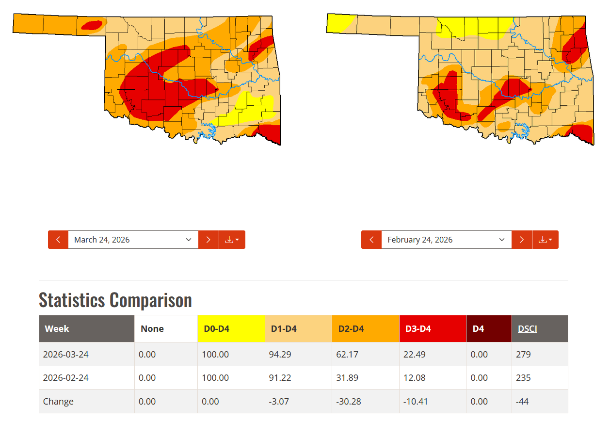
Drought coverage eases slightly as severity surges
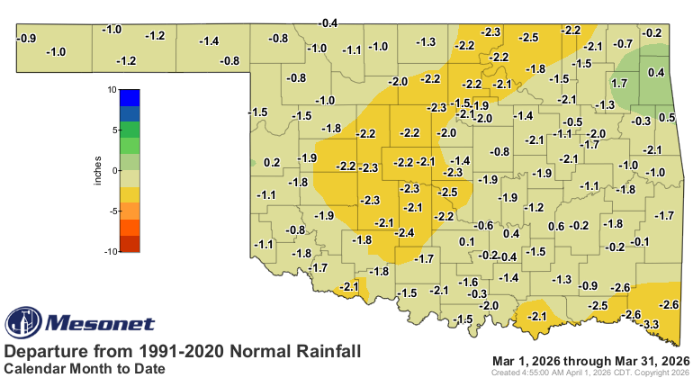
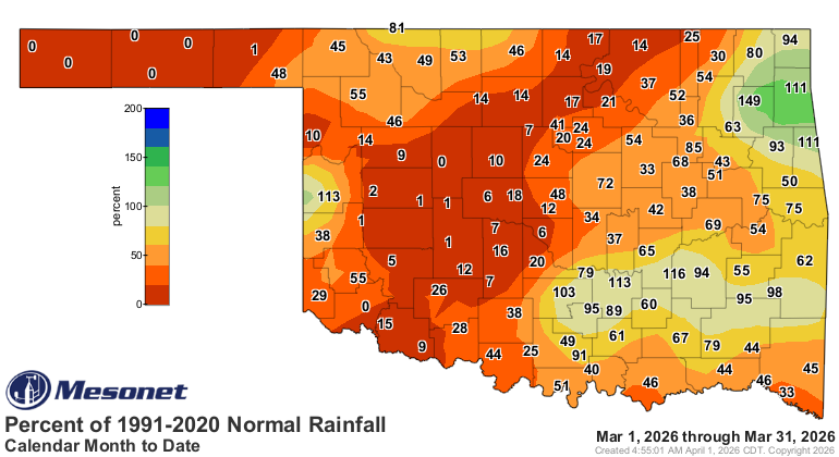
Below-normal rainfall during March helped drive worsening drought conditions
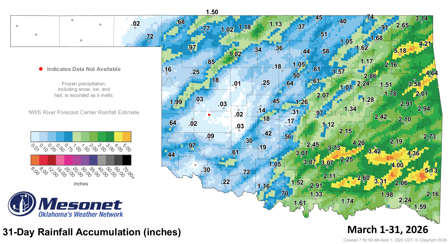
across Oklahoma. The statewide average precipitation totaled 1.32 inches, 1.46
inches below normal. The good news is the total amount of drought in the state
decreased slightly during the month, by about 3%, according to the U.S. Drought
Monitor. The bad news is that drought intensity increased sharply, with the
amount of the state in at least severe (D2) drought rising from 32% to 62%.
Reports from across Oklahoma detailed damage to an already ailing wheat crop,
partial liquidation of cattle herds requiring supplemental feed and water, and
the drying of farm ponds. Lake Lugert-Altus fell to 22 feet below normal by the
end of March, while multiple major reservoirs across the state reported levels
3–7 feet below normal.
March by the numbers
• Statewide average temperature: 60.3°F, 9.1°F above normal — the warmest March
since records began in 1895
• Temperature extremes: High of 106°F at Beaver on March 26; low of 5°F at Eva
on March 16; lowest wind chill, –6°F at Eva on March 16
• Temperatures of 90 degrees or above: 478 instances recorded at the 120
Oklahoma Mesonet sites, including 14 at or above 100°F
• Warmest and coolest locations: Highest monthly average, 64.3°F at Waurika;
lowest, 54.2°F at Kenton
• Statewide average precipitation: 1.32 inches, 1.46 inches below normal — the
29th-driest March since 1895
• Rainfall extremes: High of 5.18 inches at Pryor; no precipitation recorded at
six Mesonet sites
• Highest Mesonet wind gusts (mph): Medicine Park, March 15: 67; Vinita, March
6: 65 ; Alva, March 6: 65; Altus, Goodwell, and Mangum, March 15: 64
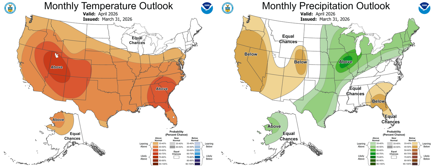
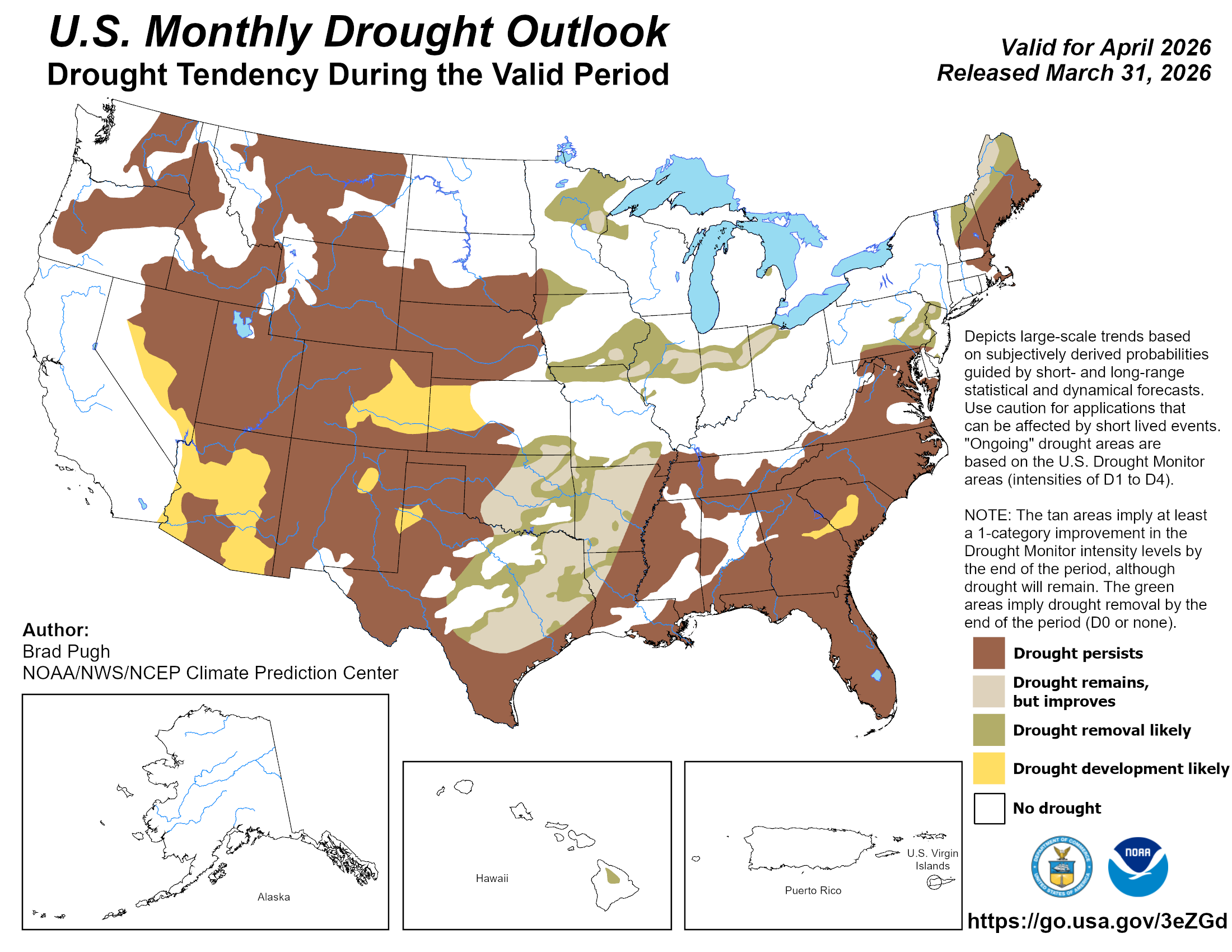
April outlook shows east-west divide
The Climate Prediction Center’s (CPC) April outlook indicates increased odds of
above-normal precipitation across all but far northwest Oklahoma, with the
greatest odds across the eastern half of the state. The outlook also shows
increased odds of above-normal temperatures statewide. The CPC’s April drought
outlook calls for drought to persist across the western one-third of Oklahoma,
but improvement, with possible drought removal, across other sections of the
state.
###
Gary McManus
State Climatologist
Oklahoma Mesonet
Oklahoma Climate Survey
gmcmanus@ou.edu
April 1 in Mesonet History
| Record | Value | Station | Year |
|---|---|---|---|
| Maximum Temperature | 98°F | ALTU | 2012 |
| Minimum Temperature | 19°F | EVAX | 2023 |
| Maximum Rainfall | 2.57 inches | TIPT | 2006 |
Mesonet records begin in 1994.
Search by Date
If you're a bit off, don't worry, because just like horseshoes, “almost” counts on the Ticker website!