Ticker for September 1, 2023
MESONET TICKER ... MESONET TICKER ... MESONET TICKER ... MESONET TICKER ...
September 1, 2023 September 1, 2023 September 1, 2023 September 1, 2023
Here comes trouble!
You're not supposed to do a press release on a Friday, you know, unless you're
trying to hide something, but since when has that stopped me? I mean, I wear
a hat for the same reason, ya know (really, bald jokes on a holiday weekend??
Are you proud of yourself? Oh wait, that was me.). But do you REALLY want to see
this the first day back from the holiday weekend?
I get a chrome dome, we ALL get a heat dome. And more drought. Doesn't seem fair,
does it? Especially for me! Now, back to August...
---------------------------------------------------------------------------------
Drought and Heat Roar Back in August
Sept. 1, 2023
Oklahoma tried its best Al Pacino impression from “The Godfather Part III”
during August, being pulled back into drought after nearly escaping its clutches
completely thanks to record moisture the previous three months. The heat and
dry weather roared back with a vengeance, however, and flash drought erupted
for the second consecutive summer. Only 13% of the state was in drought on Aug.
8 according to the U.S. Drought Monitor, contained entirely in small patches
across far southwestern and north central Oklahoma. That amount had increased
to 36% in just three weeks’ time, and the percentage of the state in at least
severe drought rose from 6% to 20% over that period. The entirety of that
increase occurred in the southern half of the state where some Oklahoma Mesonet
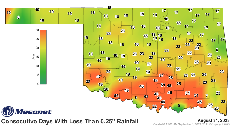
sites had gone as many as 53 days without a quarter-inch of rain in a single
day. The flash drought left much of southern Oklahoma with flagging soil
moisture, dead and dormant vegetation, and critical wildfire conditions.

Dangerous heat plagued Oklahoma thanks to the abundant rains from the previous
three months and a persistent high pressure dome that camped over the state.
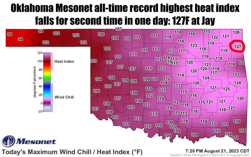
The Mesonet’s all-time record high heat index fell twice on Aug. 21 as Miami
reached an oppressive 126 degrees, only to see that mark fall a couple of hours
later when Jay reached 127 degrees. Mesonet temperature records date back to
1997. The Mesonet’s 120 sites reached a heat index of at least 120 degrees 41
times during the month, and at least 115 degrees an additional 171 times. The
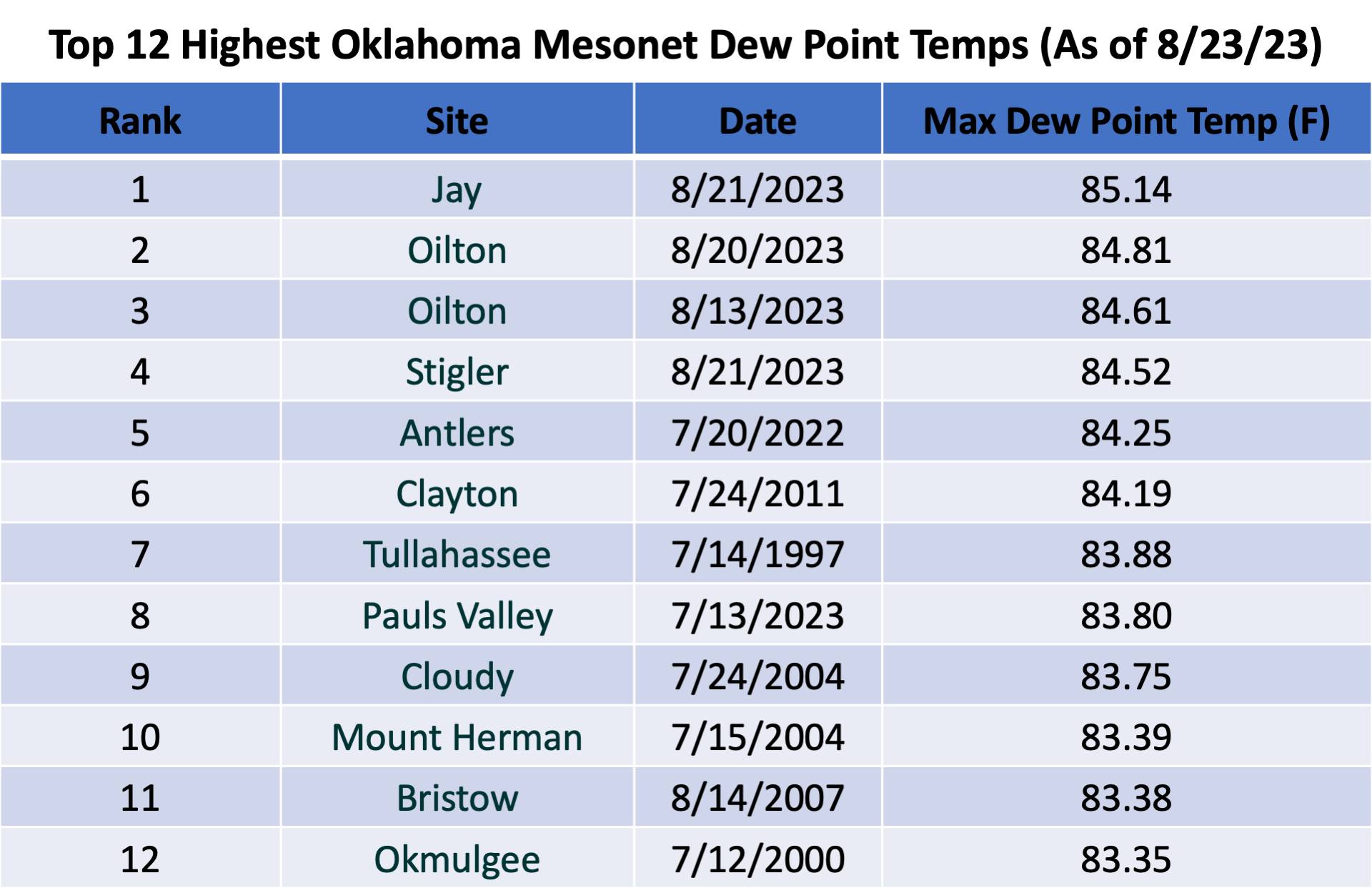
Mesonet’s record high dew point temperature was eclipsed three times during the
month, the final winner being Jay’s 85.14 degrees on Aug. 21.

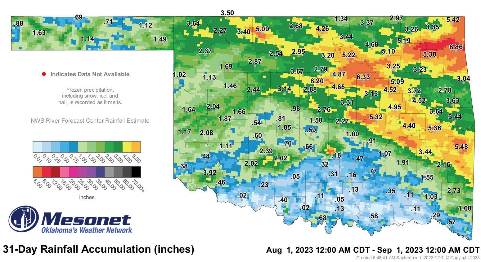
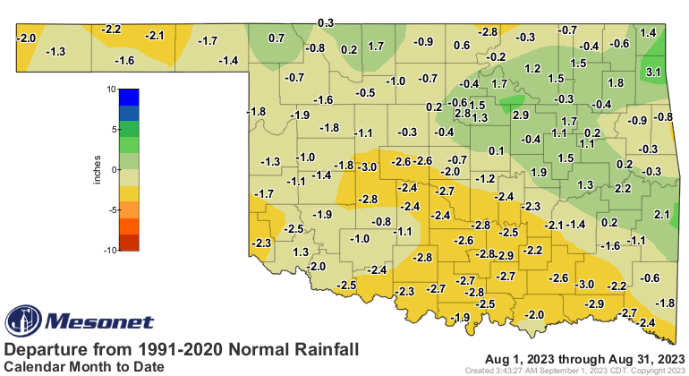
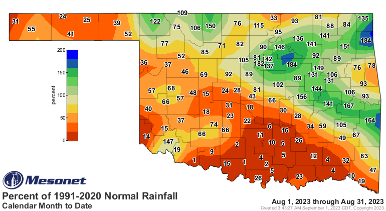
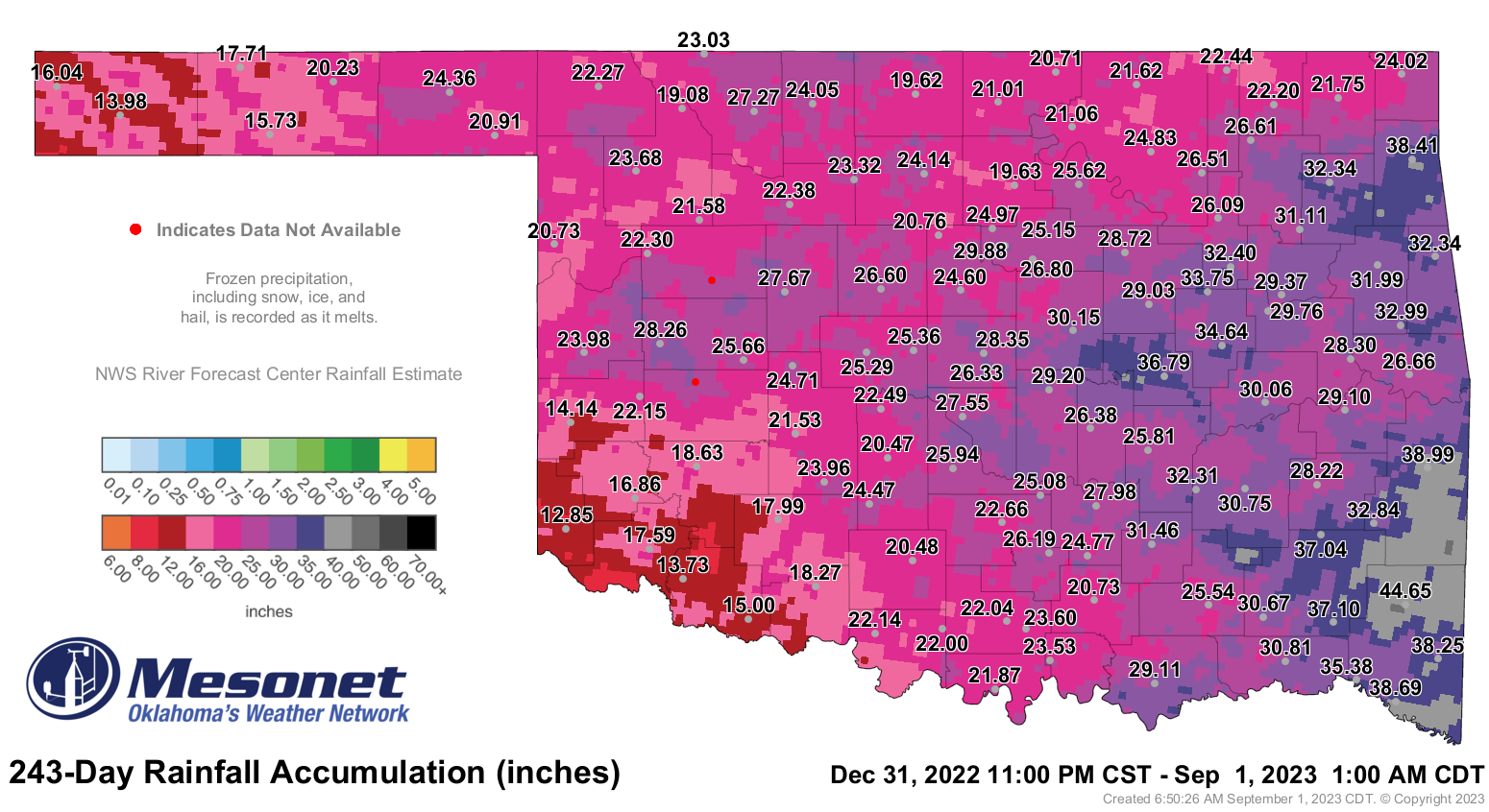
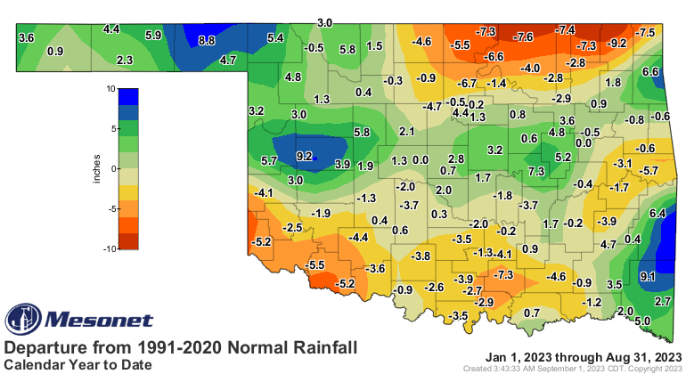
The statewide average precipitation total for the month finished at 2.23 inches,
1 inch below normal and ranked as the 44th driest August since records began in
1895. The month’s rainfall was yet another tale of the haves versus
have-nots in Oklahoma, with the southwestern half of the state going largely
without rainfall through the month, while the northeastern half enjoyed more
robust totals. Widespread deficits of 1-3 inches were common across the
southwestern half, with similar surpluses to the northeast. Totals ranged from
6.86 inches at Jay to 0.02 inches at both Grandfield and Ringling. Thirty-seven
of the Mesonet’s 120 sites recorded an inch or less for the month. The June-
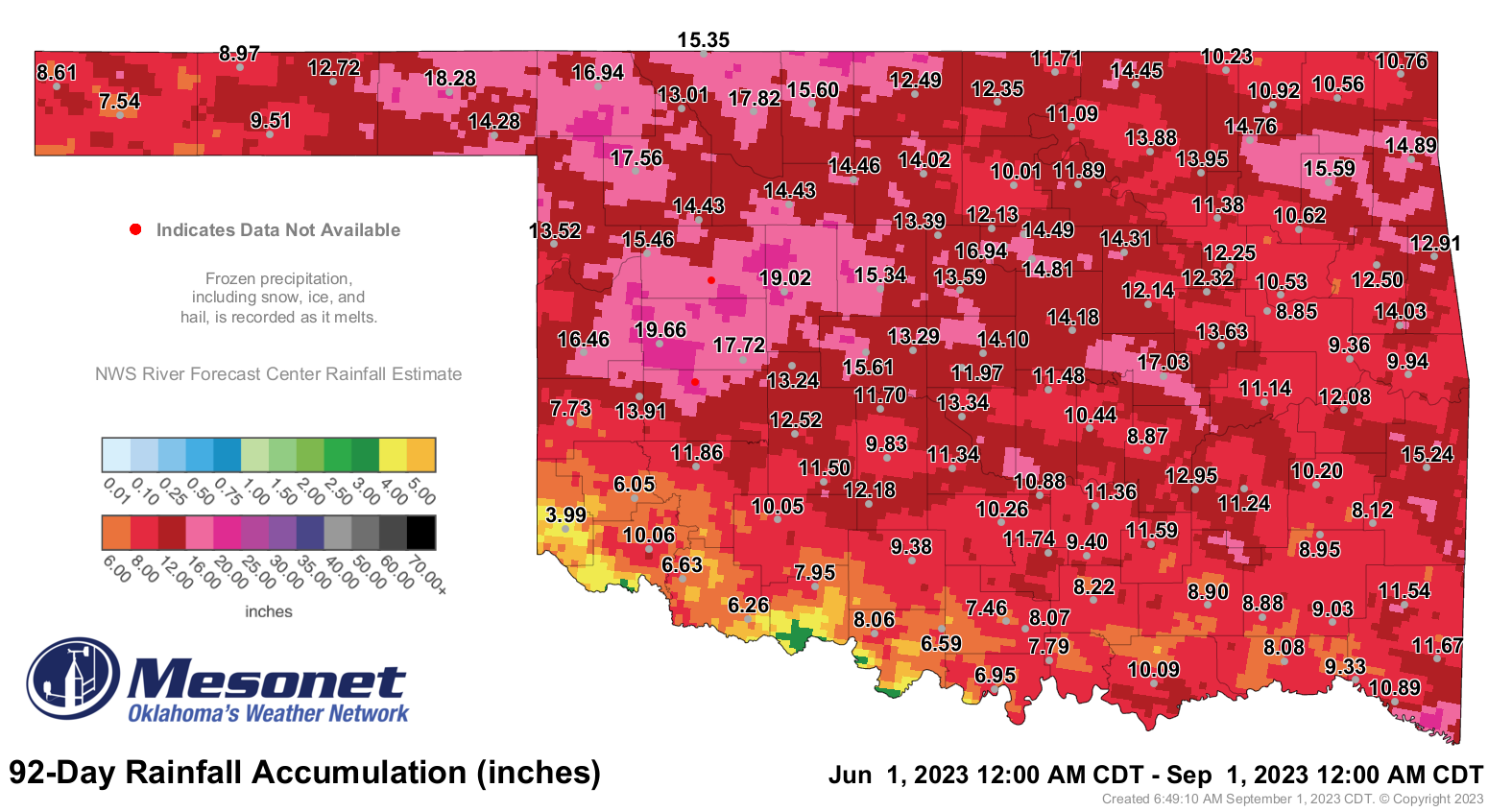
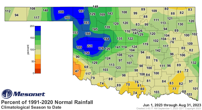
August statewide average finished at 12.31 inches, 1.62 inches above normal and
ranked as the 29th wettest climatological summer on record. West central
Oklahoma’s average of 15.82 inches ranked as their wettest summer on record,
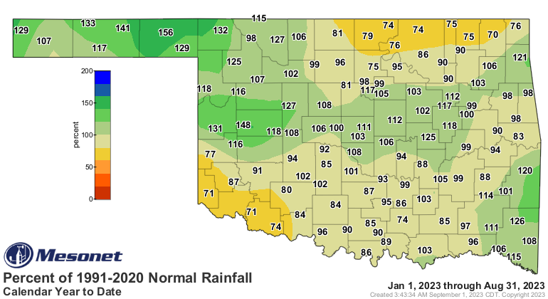
6.35 inches above normal. The first eight months of the year were the 43rd
wettest with a statewide average of 25.67 inches, 0.42 inches above normal.

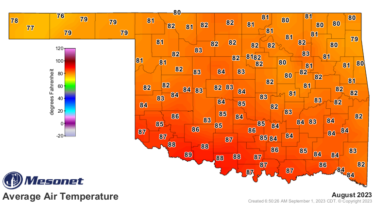
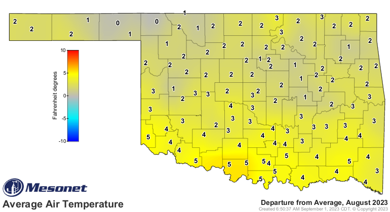
The statewide average temperature for the month was 83.1 degrees, 2.3 degrees
above normal and ranked as the 28th warmest August on record. Southwestern and
southeastern Oklahoma experienced their 8th warmest Augusts on record, and
south central finished with their 14th warmest. Grandfield was the hottest site
with an August average high temperature of 105.4 degrees, and reached triple-
digit temperatures on 25 of August’s 31 days. The month’s highest reading of
114 degrees was reported at Grandfield on the 18th, and the lowest reading of
51 degrees occurred on the 30th at Eva. Despite the unusually mild weather of
June and most of July, summer still finished 0.6 degrees above normal at 80.6
degrees, the 38th warmest June-August since records began in 1895. The first
eight months of the year were similarly warm at 63.5 degrees, 0.8 degrees above
normal and ranked as the 24th warmest January-August on record.

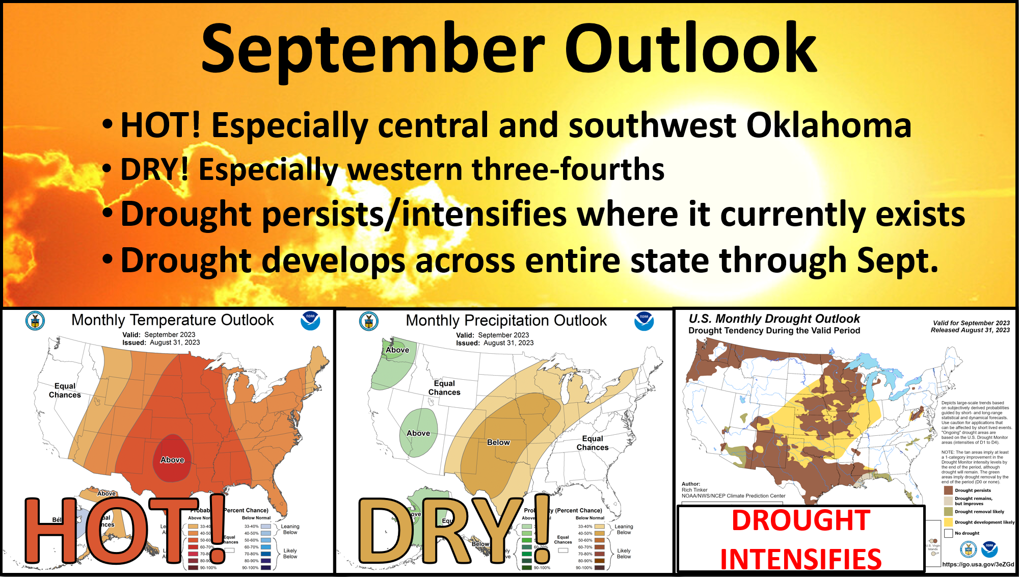
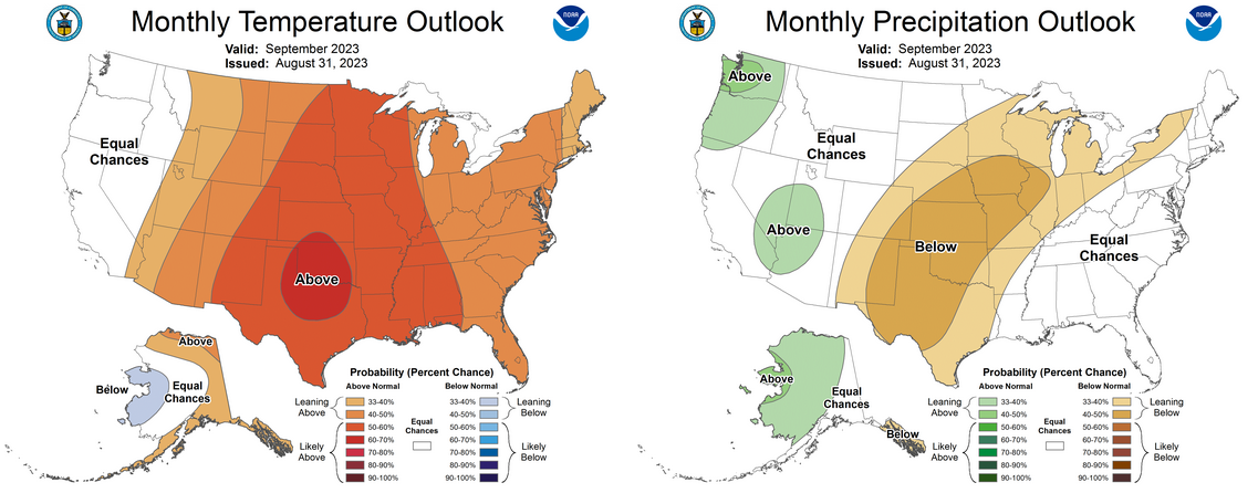
The prospects for drought relief look somewhat bleak according to the Climate
Prediction Center’s September outlooks, which indicate increased odds for above
normal temperatures and below normal precipitation for the entire state. Those
odds are particularly enhanced for both across the western three-fourths of the
state, each of which could lead to further drought intensification should they
occur. CPC’s September drought outlook reflects that possibility with drought
persistence or development considered “likely” across the entire state.

###
Gary McManus
State Climatologist
Oklahoma Mesonet
Oklahoma Climatological Survey
gmcmanus@mesonet.org
September 1 in Mesonet History
| Record | Value | Station | Year |
|---|---|---|---|
| Maximum Temperature | 110°F | WAUR | 2000 |
| Minimum Temperature | 49°F | GOOD | 2024 |
| Maximum Rainfall | 7.50 inches | BYAR | 2020 |
Mesonet records begin in 1994.
Search by Date
If you're a bit off, don't worry, because just like horseshoes, “almost” counts on the Ticker website!