Ticker for February 28, 2023
MESONET TICKER ... MESONET TICKER ... MESONET TICKER ... MESONET TICKER ...
February 28, 2023 February 28, 2023 February 28, 2023 February 28, 2023
Okie style!
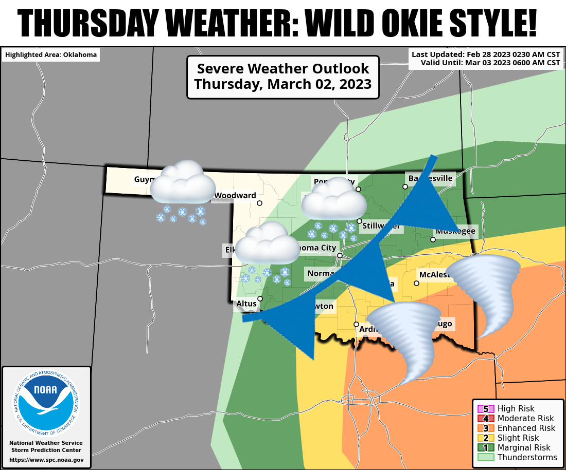
Now let's be honest here...I'm the best State Climatologist Oklahoma has at the
current moment. I'm also the worst, but that's another story. But let's also be
honest about our weather coming up this week: there's a better chance of impactful
severe weather than impactful snow. I wish that wasn't the case because of the
lovely weather we've seen so far this week, we deserve a break.
YESTERDAY was a break, wasn't it?
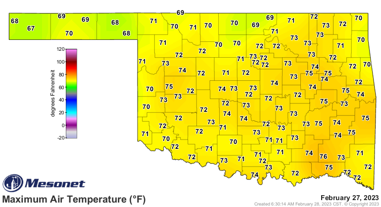
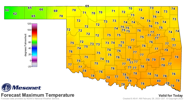
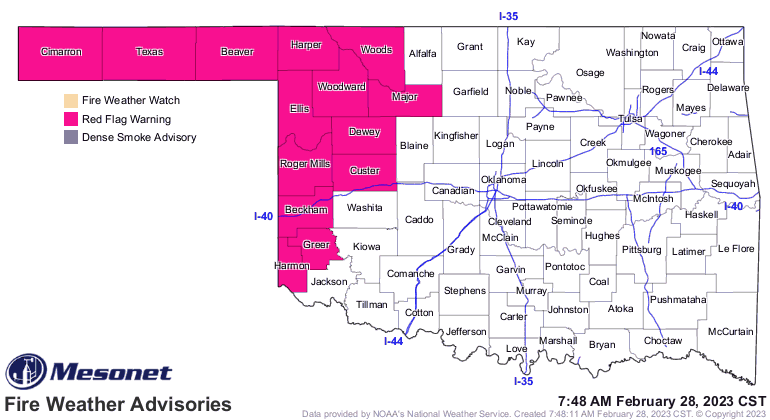
And today is going to be conditionally nice...warm weather, but the wind and
unusual warmth will add to critical fire danger across western Oklahoma. Doesn't
matter if it just rained. Until we see greening of that dead/dormant vegetation,
any dry, warm, windy weather is gonna spell trouble.
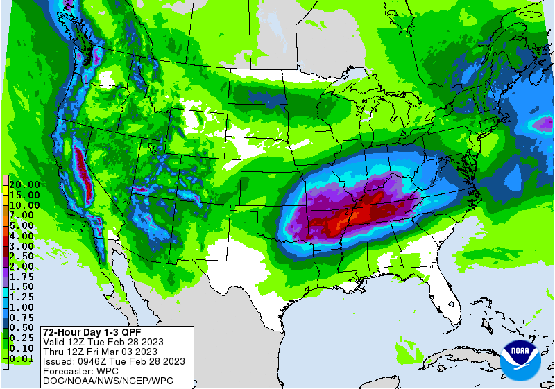
Then we see a front tonight which will cool-not-cold us down for tomorrow and
give us a bit of a rain chance, then we see the main storm system come through
on Thursday. That will set off a chance for bigtime storms across SE and SC
Oklahoma, and when the main system comes through that cold core of the upper-low
could cool the atmospheric column down enough to provide snow. Maybe an inch or
so here and there?

Temperatures at the surface appear to be BARELY freezing if at all, so any
impacts from any snow should be slight. The moisture is there to work with.
As for Sunday's tornadoes, I don't think anybody us quite sure yet on the actual
number that struck, but our friends at NWS Norman have categorized some of
the individual tracks. I'll provide those here and call it a day.
**************************************************************************
Five tornadoes were surveyed on Monday and surveys will continue this
week in other areas were tornadoes are known or suspected to have
occurred. More details will be available Tuesday. The information below
may change as more information is received.
.West of Tuttle/Far West Oklahoma City...
Rating: EF1
Estimated Peak Wind: 105 to 110 mph
Path Length /statute/: 11 miles
Path Width /maximum/: 200 yards
Fatalities: 0
Injuries: 0
Start Date: 02/27/2023
Start Time: 08:57 PM CST
Start Location: 3 W Tuttle / Grady County / OK
Start Lat/Lon: 35.28 / -97.87
End Date: 02/27/2023
End Time: 9:07 PM CST
End Location: 4 WNW Mustang / Canadian County / OK
End Lat/Lon: 35.42 / -97.79
.Goldsby/Norman...
Rating: EF2
Estimated Peak Wind: 130 to 135 mph
Path Length /statute/: 26 miles
Path Width /maximum/: 400 yards
Fatalities: 0
Injuries: 12
Start Date: 02/26/2023
Start Time: 9:09 PM CST
Start Location: 2 NE Cole / McClain County / OK
Start Lat/Lon: 35.12 / -97.55
End Date: 02/26/2023
End Time: 9:35 PM CST
End Location: 3 NE Stella / Cleveland County / OK
End Lat/Lon: 35.34 / -97.17
.Western Oklahoma City...
Rating: EF1
Estimated Peak Wind: 105 to 110 mph
Path Length /statute/: 5 miles
Path Width /maximum/: 500 yards
Fatalities: 0
Injuries: 0
Start Date: 02/27/2023
Start Time: 9:12 PM CST
Start Location: 4 ENE Mustang / Oklahoma County / OK
Start Lat/Lon: 35.42 / -97.66
End Date: 02/27/2023
End Time: 9:18 PM CST
End Location: 2 ESE Bethany / Oklahoma County / OK
End Lat/Lon: 35.49 / -97.61
..Near McCloud...
Rating: EF1
Estimated Peak Wind: 95 to 100 mph
Path Length /statute/: 6 miles
Path Width /maximum/: 100 yards
Fatalities: 0
Injuries: 0
Start Date: 02/26/2023
Start Time: 9:42 PM CST
Start Location: 2 SSE Newalla / Cleveland County / OK
Start Lat/Lon: 35.37 / -97.15
End Date: 02/26/2023
End Time: 9:48 PM CST
End Location: 2 NNW Dale / Pottawatomie County / OK
End Lat/Lon: 35.41 / -97.05
.North of Shawnee...
Rating: EF2
Estimated Peak Wind: 125 to 130 mph
Path Length /statute/: 6 miles
Path Width /maximum/: 200 yards
Fatalities: 0
Injuries: 0
Start Date: 02/26/2023
Start Time: 9:45 PM CST
Start Location: 3 SSW Aydelotte / Pottawatomie County / OK
Start Lat/Lon: 35.39 / -96.92
End Date: 02/26/2023
End Time: 9:51 PM CST
End Location: 2 SSE Meeker / Lincoln County / OK
End Lat/Lon: 35.47 / -96.87
&&
EF Scale: The Enhanced Fujita Scale classifies tornadoes into the
following categories:
EF0...Weak......65 to 85 mph
EF1...Weak......86 to 110 mph
EF2...Strong....111 to 135 mph
EF3...Strong....136 to 165 mph
EF4...Violent...166 to 200 mph
EF5...Violent...>200 mph
NOTE:
The information in this statement is preliminary and subject to
change pending final review of the events and publication in
NWS Storm Data.
*********************************************************************
Gary McManus
State Climatologist
Oklahoma Mesonet
Oklahoma Climatological Survey
gmcmanus@mesonet.org
February 28 in Mesonet History
| Record | Value | Station | Year |
|---|---|---|---|
| Maximum Temperature | 90°F | HOLL | 2006 |
| Minimum Temperature | 7°F | BEAV | 2019 |
| Maximum Rainfall | 3.70 inches | BROK | 2018 |
Mesonet records begin in 1994.
Search by Date
If you're a bit off, don't worry, because just like horseshoes, “almost” counts on the Ticker website!