Ticker for January 2, 2020
MESONET TICKER ... MESONET TICKER ... MESONET TICKER ... MESONET TICKER ...
January 2, 2020 January 2, 2020 January 2, 2020 January 2, 2020
2019 in the books!
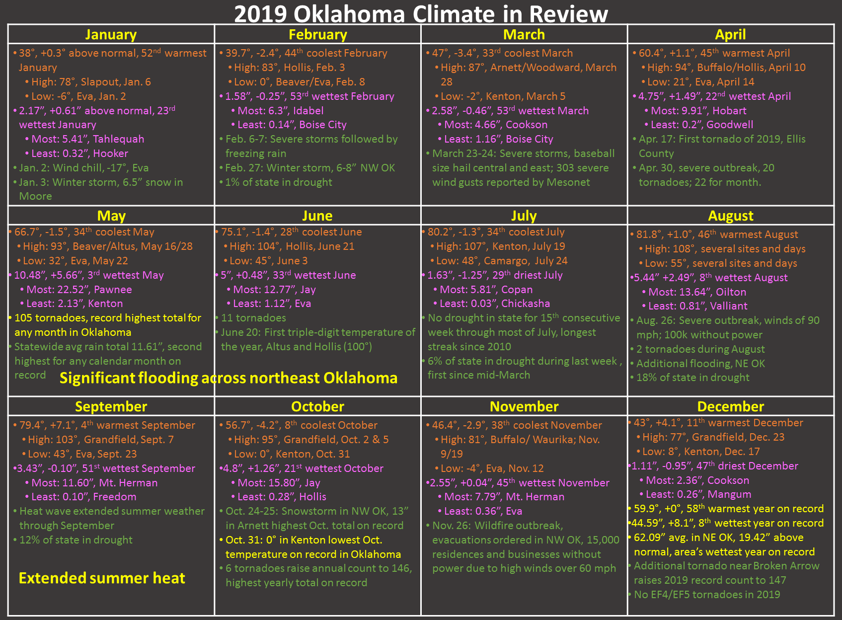
What do you do when faced with a boring week of January weather ahead? Go to
sleep until March? NO! You look back, a climatologist's specialty. We had many
momentous weather stories during 2019...a record tornado count, two years
worth of rainfall in northeast Oklahoma, two runaway barges that BARGED (first
bad wordplay of 2020, accomplished) into the state's consciousness in May, the
historic flooding across northeast Oklahoma that started in May and seemingly
never stopped. But within those big stories lie the little ones that actually
make up our day-to-day weather, like the lack of heat in June, or the lowest
temperature (zero degrees) ever recorded in October (or that early in the
season) on Halloween at Kenton.
So many tidbits, so little time. Without further adewpoint (that's #2), I
present the final monthly summary of 2019.
-------------------------------------------------------------------------------
December Tornado Caps Record Year
Warm and mostly dry December weather dashed any hopes of walking in a winter
wonderland, including dreams of a white Christmas. Very little in the way of
wintry weather was seen during the month, save for a couple of inches of snow
in the western Panhandle and a few bouts with freezing drizzle and fog.
Christmas Day itself was the second warmest on record with a statewide average
temperature of 57 degrees, topped only by 2016’s 57.6 degrees and far removed
from 1983’s record cold of 4.7 degrees. Spring weather took up the slack for
the dearth of winter excitement. A storm system moved through on December 27-28
and brought widespread beneficial rainfall across all 77 Oklahoma counties.
Severe weather struck eastern Oklahoma on the 28th and produced the year’s
final tornado near Broken Arrow. The twister – rated an EF0 on the Enhanced
Fujita Scale – damaged power poles, trees and a few structures. The year’s 147
tornadoes are the most in Oklahoma since accurate records began in 1950,
besting 1999’s previous record total of 145. May’s 105 tornadoes made up the
bulk of the year’s record total, also the highest count for any month on record
in the state. Despite the record number, there were no violent tornadoes – EF4
or EF5 – in the state during 2019.
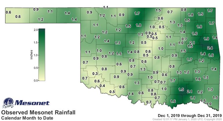
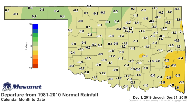
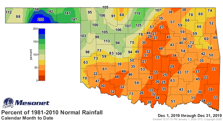
According to preliminary data from the Oklahoma Mesonet, the statewide average
precipitation total was 1.11 inches, 0.95 inches below normal to rank as the
47th driest December since records began in 1895. Far northwestern Oklahoma and
the Panhandle enjoyed small surpluses to rank as their 39th and 22nd wettest
Decembers on record, respectively. The southeast’s average total of 1.39 inches
was 2.61 inches below normal to rank as their 14th driest. Only three of the
Mesonet’s 120 sites recorded more than 2 inches of rain for the month, with
Cookson leading the state at 2.36 inches. Tipton had the lowest total with 0.44
inches.
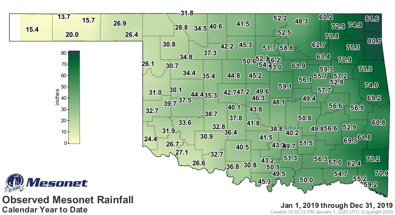
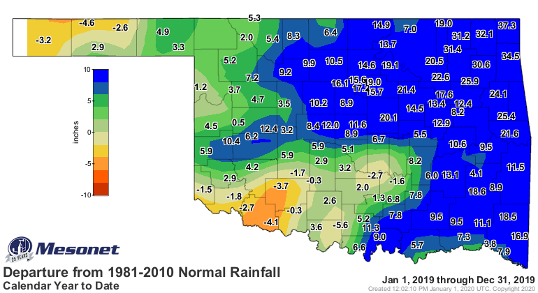
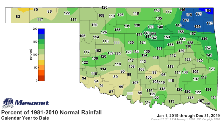
Despite the dry finish, 2019 managed to end as the eighth wettest year on
record with a statewide average of 44.59 inches, 8.09 inches above normal. The
year was easily the wettest on record for the northeast at 62.09 inches, 19.42
inches above normal, obliterating their previous record of 57.82 inches from
1973. Miami’s 2019 total of 81.64 inches led the state and became one of the
highest recorded amounts in state history, as did Jay’s 80.67 inches. The
National Weather Service cooperative observing station at Daisy has the record
high total of 89.69 inches from 2015. The Mesonet site at Eva reported the
lowest 2019 total with 13.65 inches. Forty-nine Mesonet stations recorded at
least 50 inches of rainfall for the year.
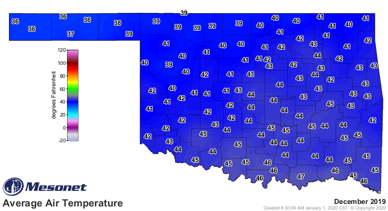
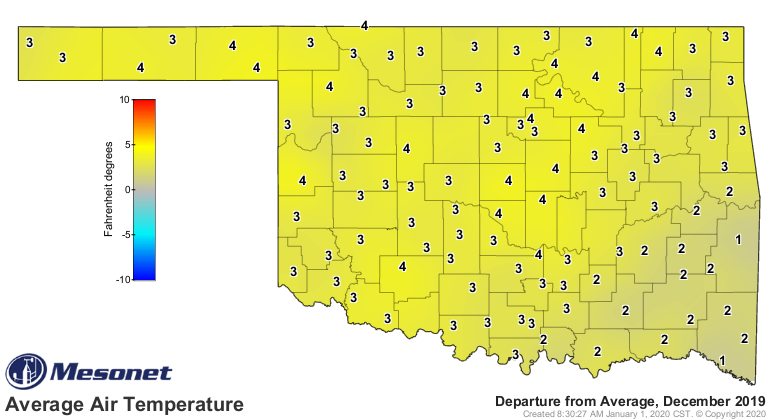
The month was substantially warmer than normal. The statewide average of 43
degrees ranked as the 11th warmest December on record, 4.1 degrees above normal.
The average maximum temperatures were even higher, finishing 5-6 degrees above
normal across parts of western Oklahoma. Boise City reported the highest single
reading of the month at 77 degrees on the 23rd. The lowest temperature of 8
degrees came on the 17th at Kenton. That was the only single-digit reading at
the Mesonet’s 120 stations during the month.
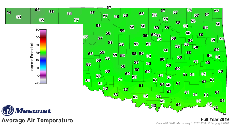
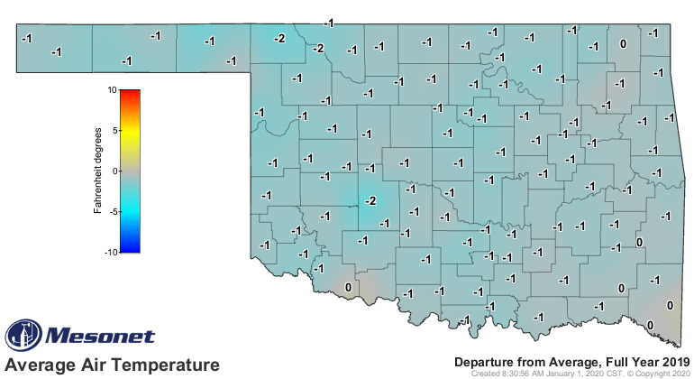
The year came in exactly normal at 59.9 degrees, the 58th warmest on record.
The highest temperature for 2019 was 108 degrees from Hooker on August 19,
while the lowest of minus 4 degrees was recorded at Eva on November 12. The
lowest calculated wind chill was minus 17 degrees at Eva on January 2, and the
highest heat index of 118 degrees came at Bixby on August 26.
The rain at the end of the month managed to halt any drought progression or
intensification across western Oklahoma, despite the previous absence of
moisture. Drought coverage had increased from 12% to 18% during December
according to the U.S. Drought Monitor, before shrinking to a little more than
10% on the year’s final report. The amount of the state in abnormally dry
conditions – signaling areas in danger of progressing to drought – shrank from
39% to 24%.
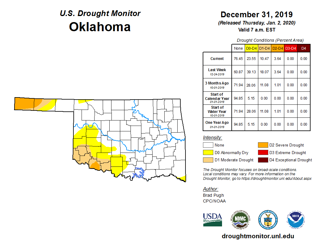
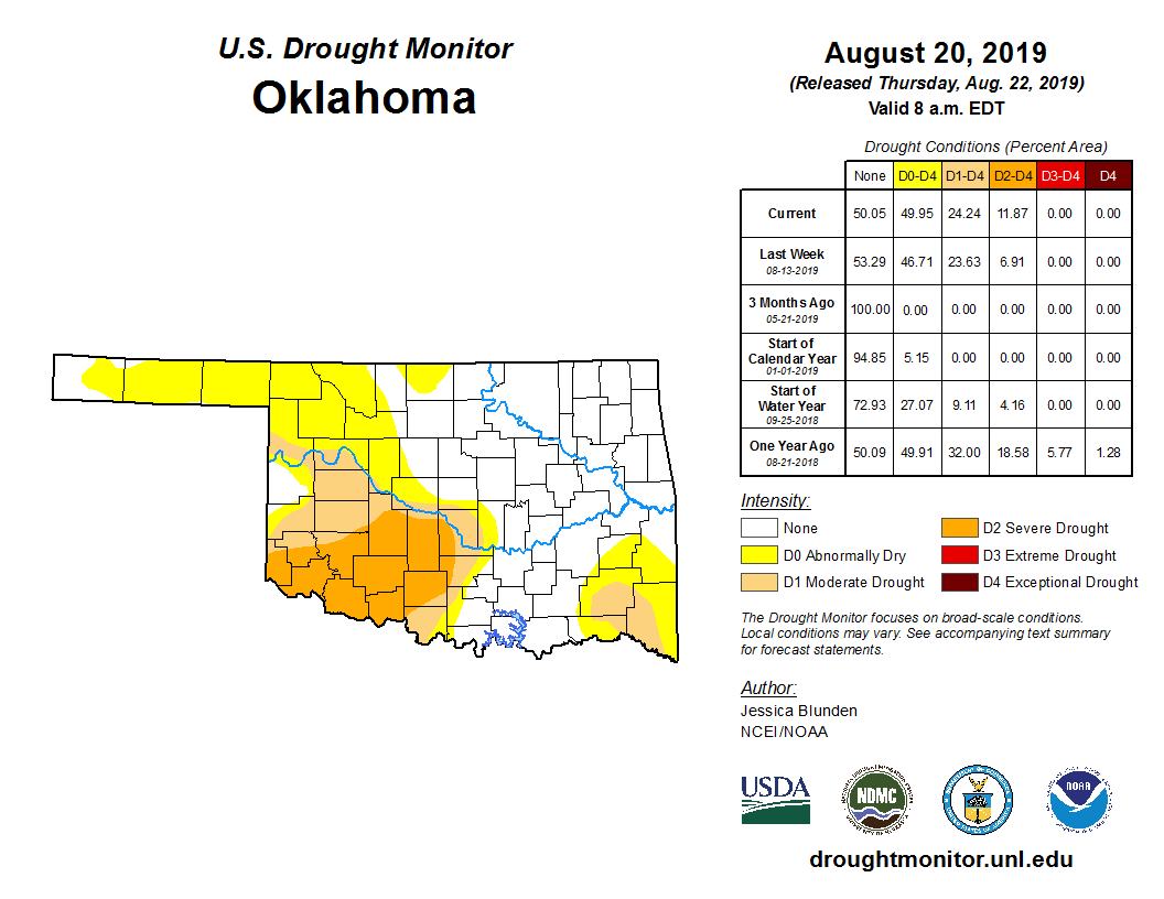
The greatest extent of drought during 2019 came on the August 20 Drought
Monitor at 24%.
Drought was absent from the state for 27 weeks throughout the year, including
15 consecutive weeks from March 19 to July 23 – the longest such streak since
2010.
The Climate Prediction Center’s January outlooks show increased odds of above
normal temperatures for all of Oklahoma save for the Panhandle, with those odds
being greater in southeastern Oklahoma. Odds are even for above-, below- and
near-normal precipitation over the entire state. CPC’s January Drought Outlook
indicates the persistence of drought in the western Panhandle and southwestern
Oklahoma, although the drought’s areal coverage should decrease somewhat in
those areas.
Gary McManus
State Climatologist
Oklahoma Mesonet
Oklahoma Climatological Survey
(405) 325-2253
gmcmanus@mesonet.org
January 2 in Mesonet History
| Record | Value | Station | Year |
|---|---|---|---|
| Maximum Temperature | 80°F | BURN | 2004 |
| Minimum Temperature | -10°F | KENT | 2013 |
| Maximum Rainfall | 2.55″ | CLOU | 2005 |
Mesonet records begin in 1994.
Search by Date
If you're a bit off, don't worry, because just like horseshoes, “almost” counts on the Ticker website!