Ticker for April 26, 2016
MESONET TICKER ... MESONET TICKER ... MESONET TICKER ... MESONET TICKER ...
April 26, 2016 April 26, 2016 April 26, 2016 April 26, 2016
What the hail?
You can feel it, can't ya? You walk outside and it's a tad hard to breathe, sort
of what Sandy must go through in Bikini Bottom. That's rich, low-level moisture
from the Gulf of Mexico...fuel for storms and indicated on our Mesonet dewpoint
map.
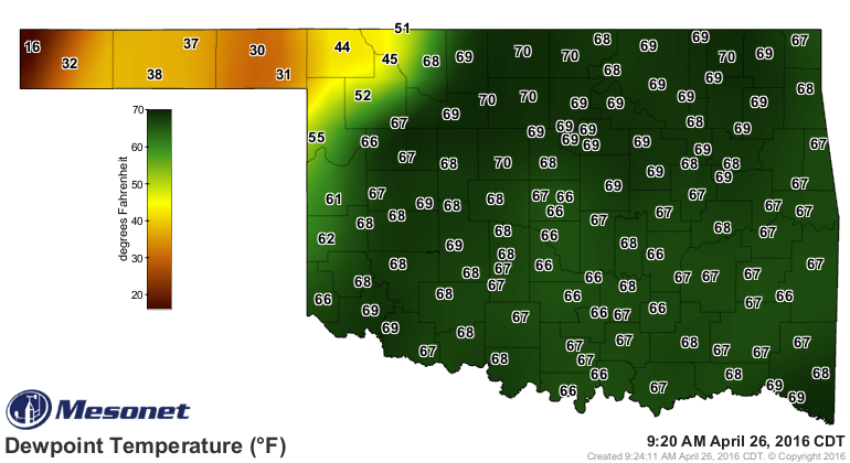
Seeing dewpoints in the 70s in northern Oklahoma with a strong jet stream
overhead and a surface low approaching from the west causes a meteorologist's
alarm bells to start going off. And this much anticipated (dreaded!) storm
day has finally arrived.
Well, not much has changed since yesterday concerning this severe weather event,
but the folks that forecast these things are getting a bit of a better handle on
it. And that "better handle" yields...there is still lots of uncertainty over
the timing and location of possibly at least a couple of rounds of severe weather.
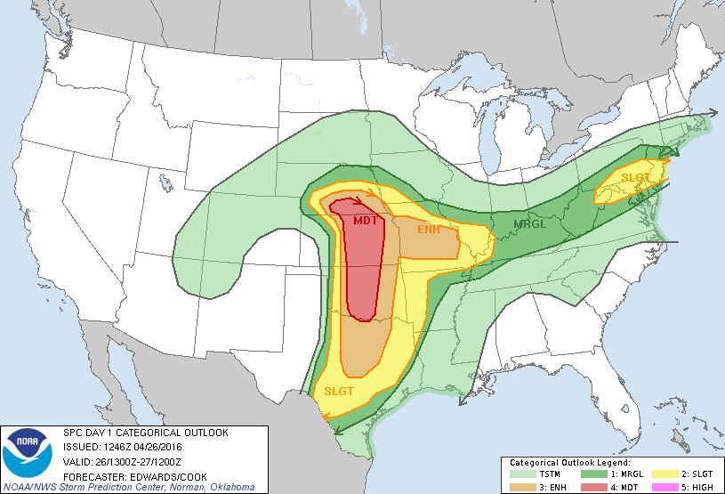
And with that sentence, I've used up all of my of's! Here are the latest graphical
outlook products from the Storm Prediction Center, and take notice that while the
risk of tornadoes (significant tornadoes, EF2 or greater) is non-insignificant,
the chances for very large hail are significantly significant.
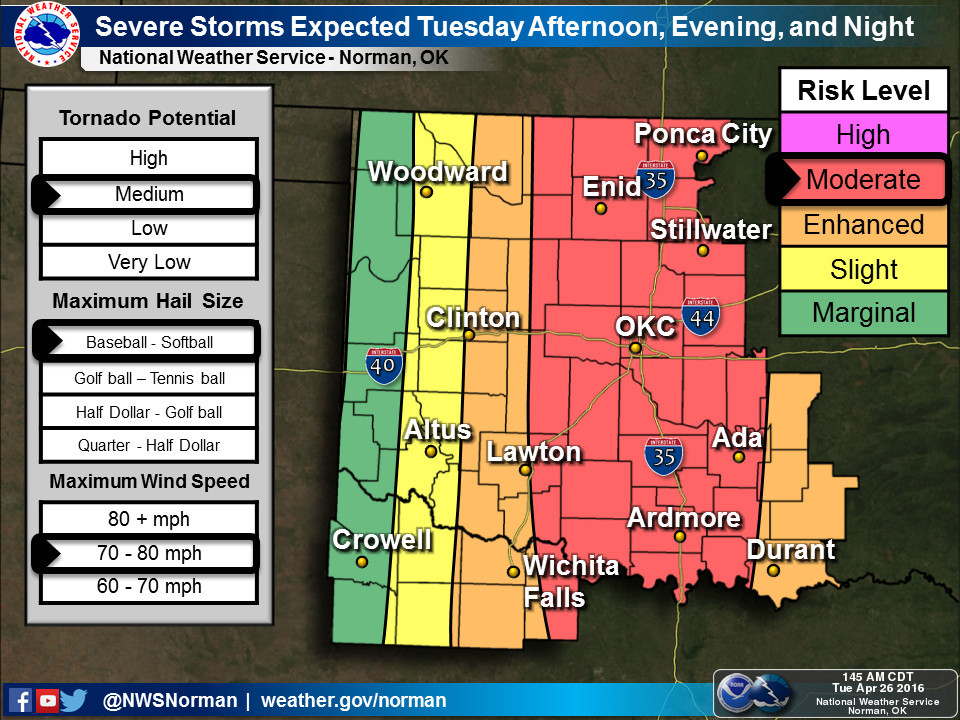
There is a moderate risk of severe weather today, hail-driven to a large degree,
from southern Nebraska all the way down to N Texas.
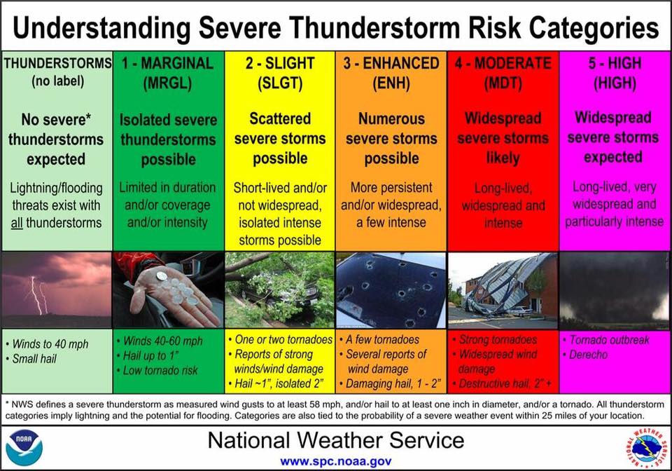
As a refresher to what those categories entail, here's the SPC risk category
descriptions once again.
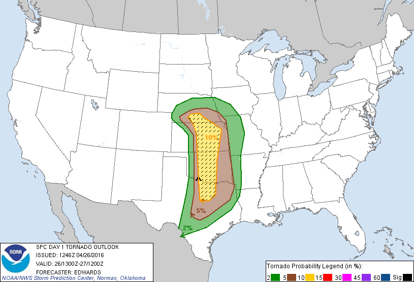
Here's the SPC tornado probability map for today. Take notice that inside the
hatched area, there is a 10% or a little greater of an EF2-EF5 tornado within
25 miles of a point within that outline. Now don't panic, that does not mean
that everybody will see tornadoes today. The storms producing these tornadoes
are very likely to be widely spaced and discrete, so your chances of
getting missed are overwhelmingly larger than even getting close to a tornado
(if any even form).
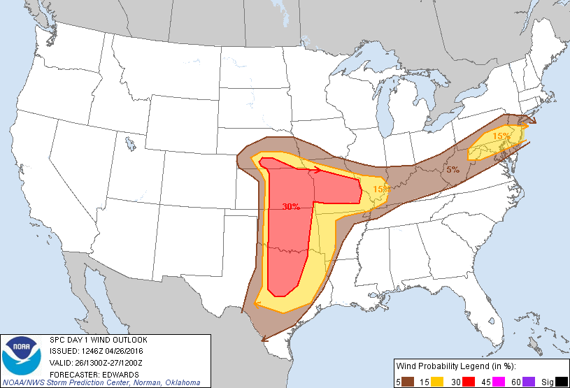
Here's the wind probability map, and most of Oklahoma is in the 30% chance of
seeing a damaging t-storm wind (57mph or greater) within 25 miles of a point.
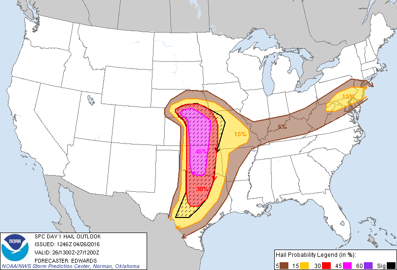
And finally, here we see the biggest widespread risk, and what's really driving
the large moderate risk area for today...the hail risk. From southern NE through
SC OK, we see a 45% chance of two inch diameter hail or larger within 25 miles
of some point. Now here you have a much better chance of getting dinged, pardon
the pun, than from a tornado since hail tends to be a bit more widespread. Again,
the caution is if all this is coming from discrete supercells, your chance of
getting hit goes down as opposed to a squall line, for instance.
As per usual, here are the takes from the local NWS offices to give you a better
idea of what to expect.
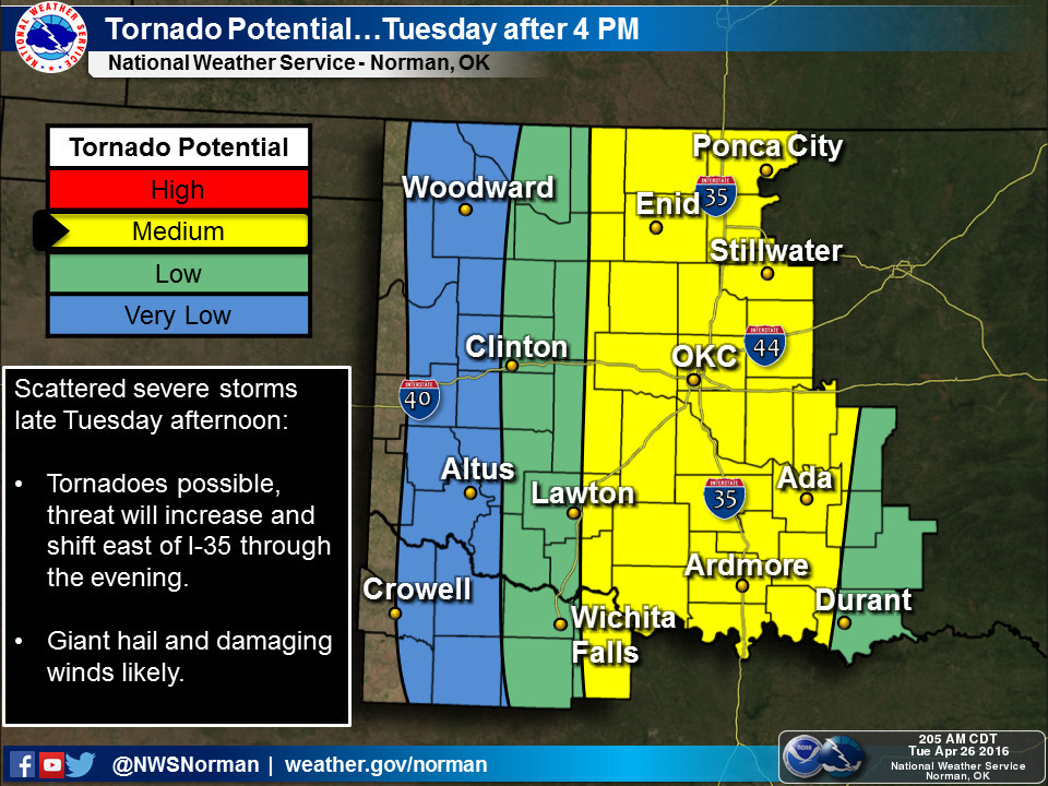
For the Norman NWS forecast area:
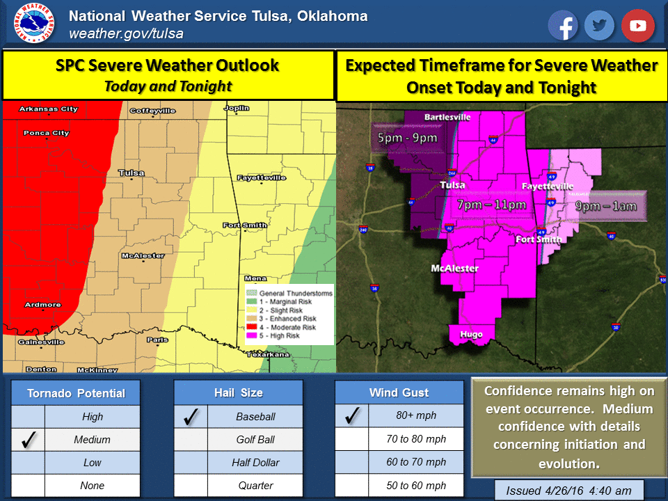
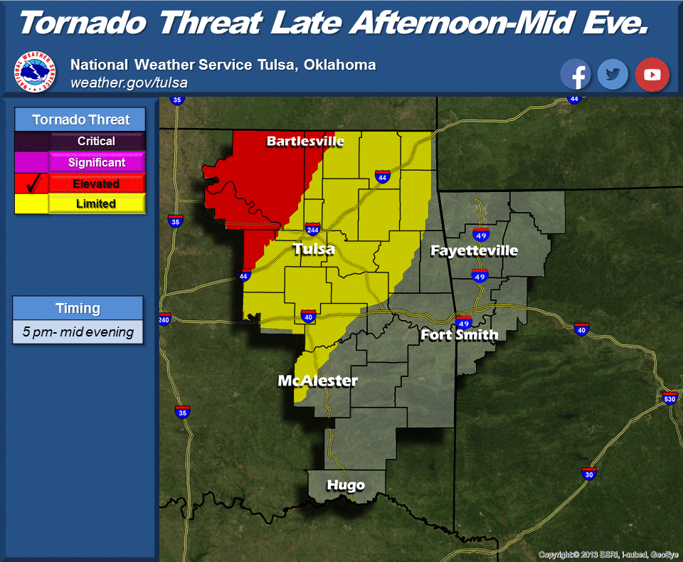
For the Tulsa forecast area:
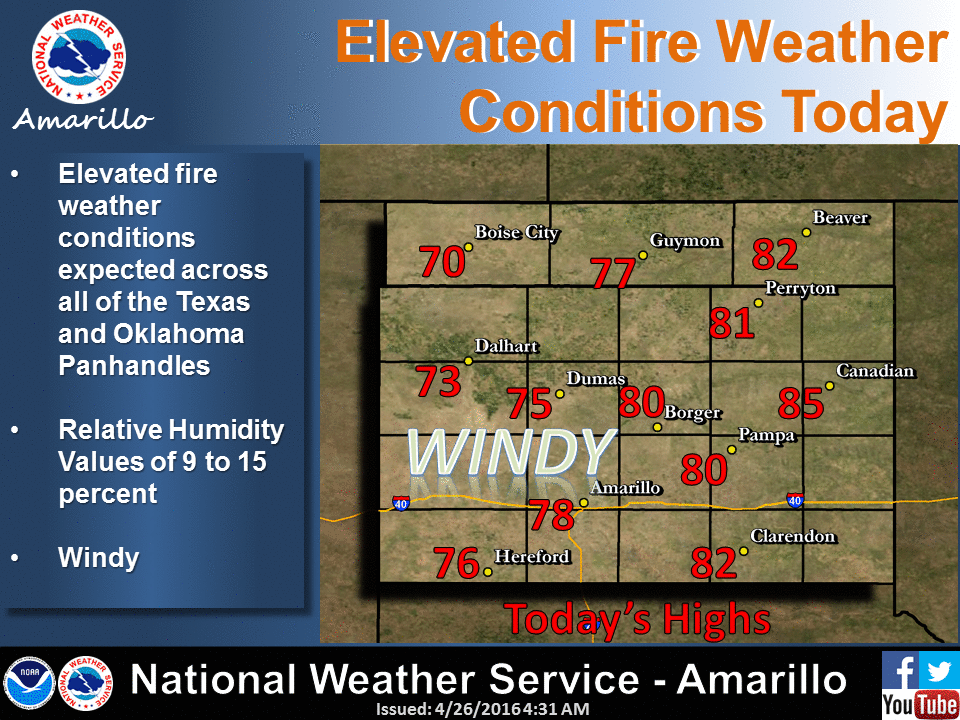
And of course the Panhandle has to be different. They said to heck with storms,
let's play with fire today. From the NWS Amarillo office (covering the OK
Panhandle):
And here are some tidbits about today's weather from the Norman NWS office:
- the moderate risk is mainly because of the very large hail that's expected.
The tornado risk is still there, but is not the primary threat.
- forecast is still a little messy this morning with uncertainties about
when storms will form and what they will look like. It looks like the
wind shear will not be extremely favorable for numerous strong-violent
tornadoes, but it only takes one. Don't focus just on the tornado threat,
but be ready just in case
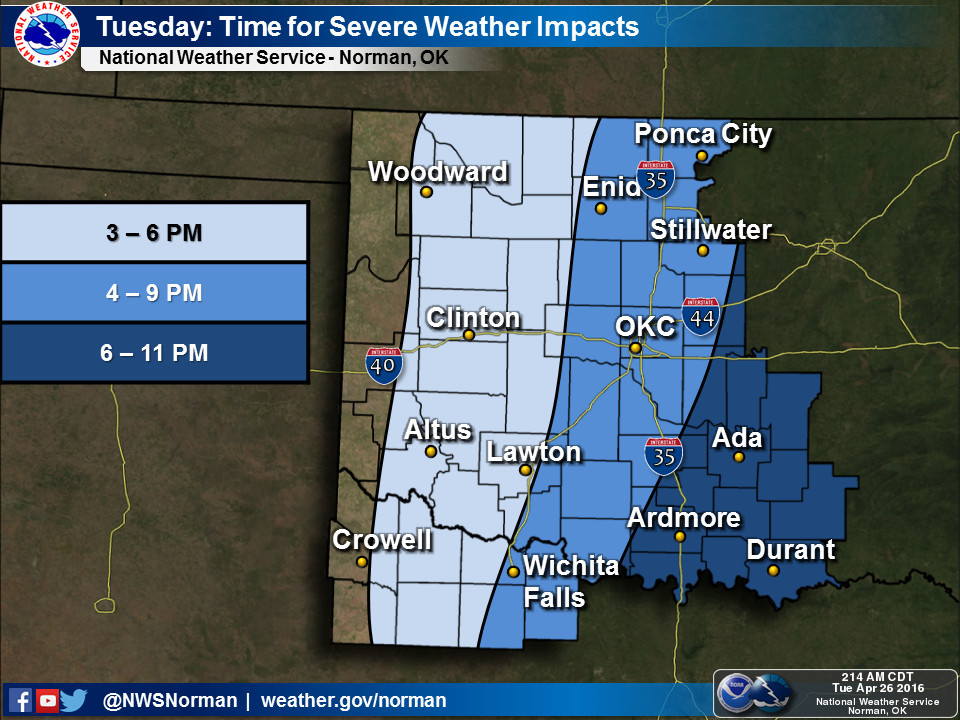
- we could see showers and weaker storms develop before mid afternoon, but
right now it looks like the most significant storms will be after 3 or 4 pm.
- we expect scattered storms to form after 3 or 4pm along and just east of
a dry line which should be somewhere along a line from Alva to Clinton
to Vernon, TX. Storms will quickly become severe.
- bottom line: stay alert. Not everyone in the moderate risk area will see
severe weather, but if you have a storm near you later today, it will
mean business and should be taken seriously. Think carefully about any
travel plans between 4pm and 8pm. You do not want to be on the road with
severe storms producing large hail. Hail in the most intense storms will
be big enough damage homes and vehicles.
Okay, there's not much I can do to alleviate the uncertainty of any of this
that still remains as to timing, locations, etc. So the advice remains the same.
Stay weather aware with your local NWS offices and media sources.
Have your severe weather safety plan in place.
Give yourself plenty of time and fluidity as the weather scenario unfolds and
evolves.
Gary McManus
State Climatologist
Oklahoma Mesonet
Oklahoma Climatological Survey
(405) 325-2253
gmcmanus@mesonet.org
April 26 in Mesonet History
| Record | Value | Station | Year |
|---|---|---|---|
| Maximum Temperature | 95°F | ALTU | 2014 |
| Minimum Temperature | 25°F | BOIS | 2006 |
| Maximum Rainfall | 5.51 inches | BOWL | 1998 |
Mesonet records begin in 1994.
Search by Date
If you're a bit off, don't worry, because just like horseshoes, “almost” counts on the Ticker website!