Ticker for March 13, 2014
MESONET TICKER ... MESONET TICKER ... MESONET TICKER ... MESONET TICKER ...
March 13, 2014 March 13, 2014 March 13, 2014 March 13, 2014
Drought vs. Rain...who will win?
Before we get started on the subject at hand, let me show you a cool picture
provided by the National Weather Service office out of Amarillo. This picture
of Tuesday's dust storm, taken from the air, was actually snapped by Ryan Scott
from the Dallas area as he was flying overhead (presumably in an airplane, but
imagine how much cooler this story would be if he wasn't!).
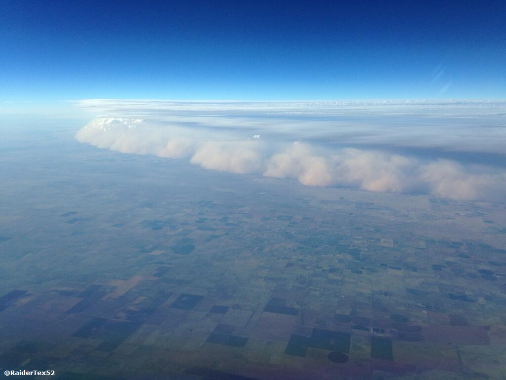
Again, very cool! Not-so-cool, today's new U.S. Drought Monitor graphic which
shows drought once again advancing across the state.
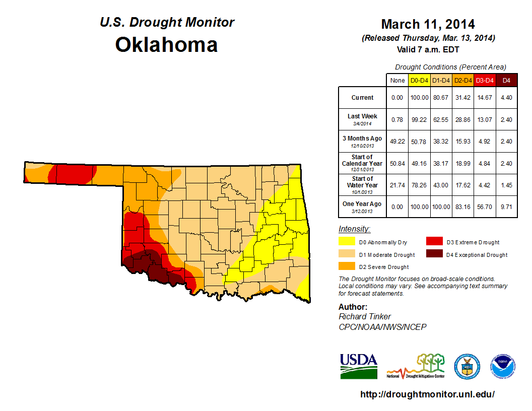
The amount of Oklahoma now considered to be in drought by the Drought Monitor
effort (at least D1-Moderate Drought) rose from 63% to 81%, thanks to more dry
weather and another dose of on-again/off-again warmth, strong winds and extremely
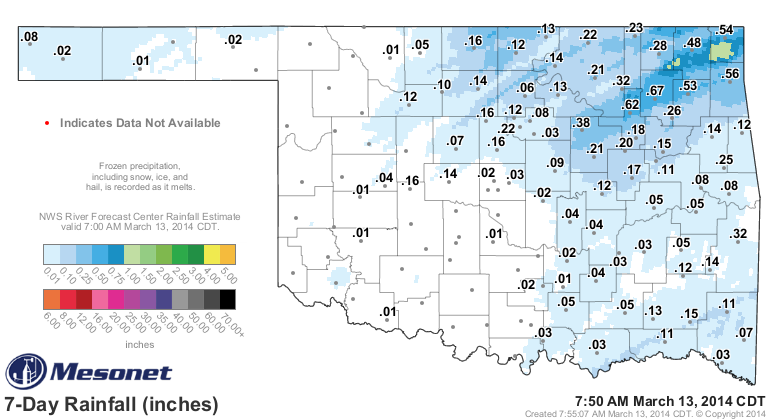
low humidity. In other words, lots of fire danger. The rainfall maps tell the
story, from the last 7 days all the way out to the last 120 days.
7-day totals
120-day maps
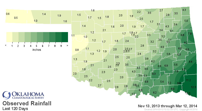
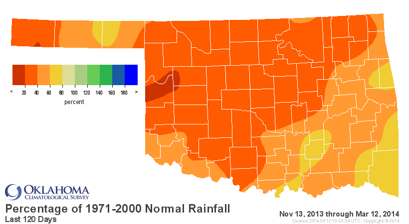
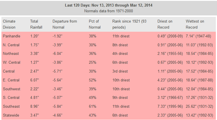
Dating back to November 13, that intervening period has been the 6th driest
statewide since 1921 ... 3rd driest for central Oklahoma at nearly 6 inches
below normal. So in other words, from the late fall through the winter, it's
been flat-out dry. We've had a few decent storms here and there, including
those of the winter variety, but now we need the spring rains to kick in.
Speak of the angel (we'll make drought the devil here), some decent rain is
in the forecast! Here's the 7-day moisture forecast from WPC.
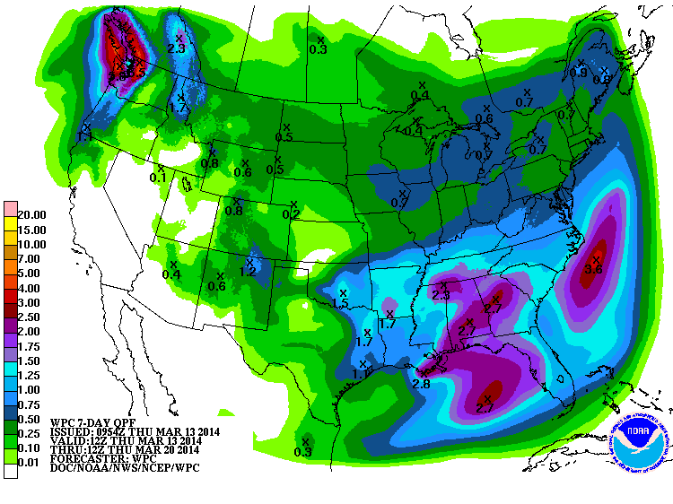
a very nice 1.5-inch bullseye smack dab in the middle of the state. I'd like to
see it a bit farther to the west, but we'll take what we can get anywhere in
the state at this point. Almost all of this is predicted to fall this weekend,
and we might even see some severe storms in the southeast.
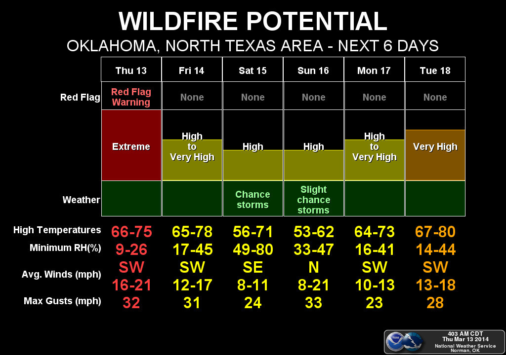
Until then, we have wildfires to deal with, and today is going to be a doozy
statewide, but particularly out west. Check out the graphics from the local
NWS folks for more info on high wildfire danger today.
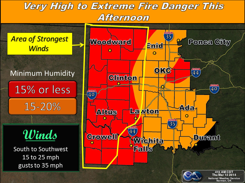
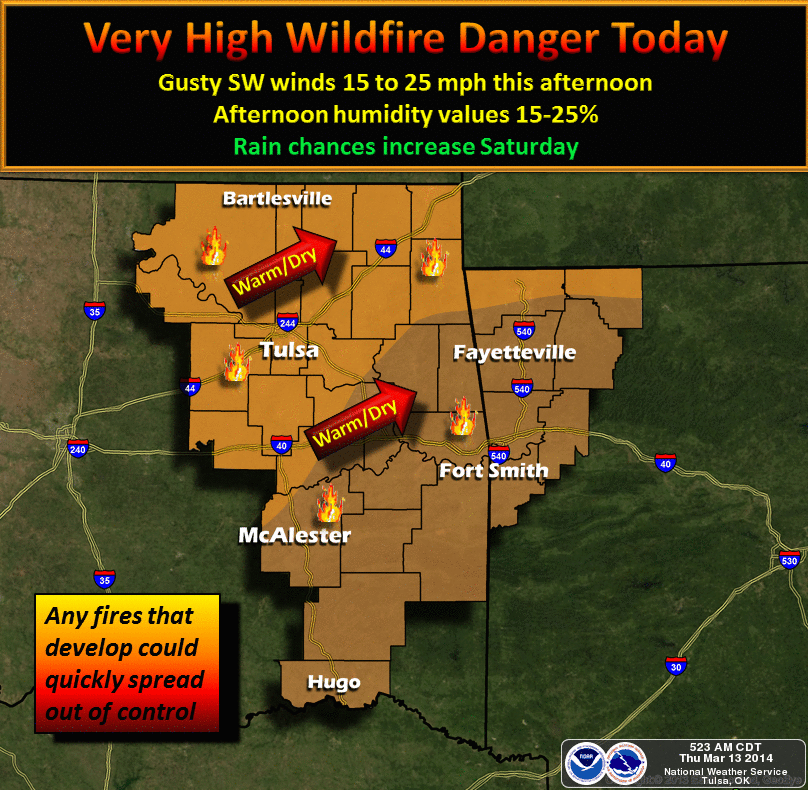
In fact, there is a Red Flag Fire Warning issued for western Oklahoma,
signalling a high likelihood that any fires that do develop will spread rapidly
out of control. Don't be shocked if that warning expands across more of the
state later.
Even with the rain, high fire danger will return later. Why high fire danger
despite rain? Well, the simple truth is we're not green yet. When that moisture
falls, given another day with strong winds and low humidity, the dormant/dead
vegetation is right back ready to catch fire again. So we do need some warmth
along with that rain to spread along the greening of the state and quash some
of this persistent-yet-normal fire danger.
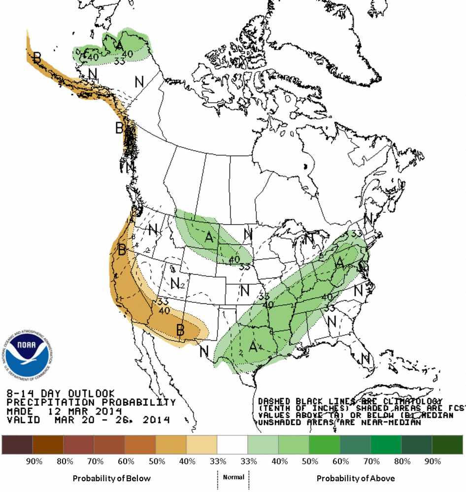
There is a sign of more rain on the horizon after this weekend, we just might
have to wait a week longer or so, at least according to the CPC outlooks. This
is for the March 20-26 period, and it pertains mostly to the southeastern part
of the state. But at least we don't see increased odds of below normal amounts
across the west. I think at this point, normal would be just fine with them.
Gary McManus
State Climatologist
Oklahoma Climatological Survey
(405) 325-2253
gmcmanus@mesonet.org
March 13 in Mesonet History
| Record | Value | Station | Year |
|---|---|---|---|
| Maximum Temperature | 92°F | ALTU | 2002 |
| Minimum Temperature | 14°F | KENT | 2006 |
| Maximum Rainfall | 3.50 inches | LANE | 1995 |
Mesonet records begin in 1994.
Search by Date
If you're a bit off, don't worry, because just like horseshoes, “almost” counts on the Ticker website!