Ticker for January 7, 2014
MESONET TICKER ... MESONET TICKER ... MESONET TICKER ... MESONET TICKER ...
January 7, 2014 January 7, 2014 January 7, 2014 January 7, 2014
Icewata
Another on-topic quote from one of my daughters this morning: "Daddy, this is the
coldest winter I can remember!" Well, seeing that she's eight, that's not really
saying much. She was alive for the late-January through mid-February 2011 icebox,
but I guess that's slipped her memory. But she was also probably a big young for
the frigid winter of 2009-10 as well, easily one of the 10 coldest on record for
the state (8th coldest, in fact).
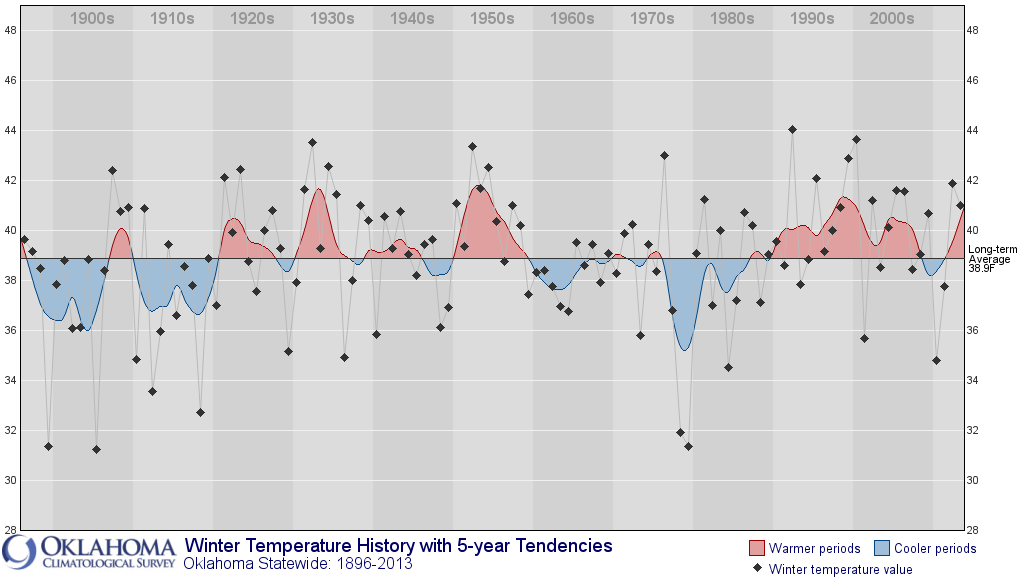
So yes, we have had cold winters recently. We still have about two months to go
on this one (climatological winters run December-February), but December (17th
coolest on record) and early January have certainly given the winter of 2013-14
a bit of a head start.
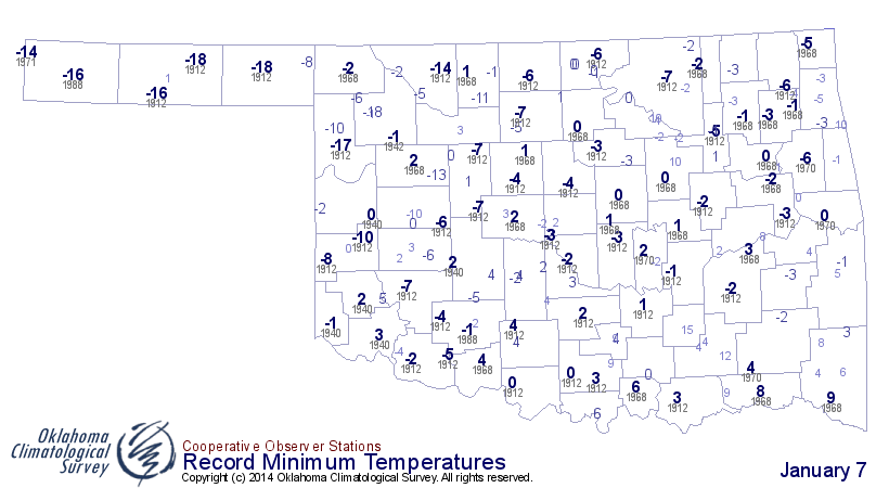
Records were falling left and right yesterday, both with the minimum temperatures
but also the high temperatures that ended up looking like lows.
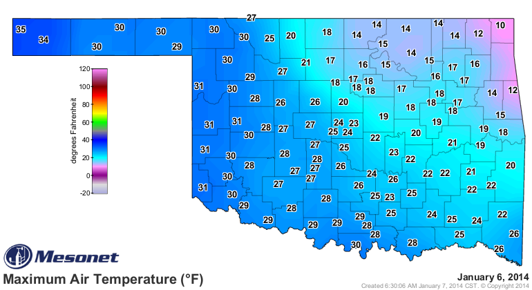
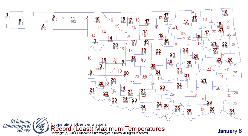
Just how cold was yesterday across the state? Well, just brute forcing the data,
taking an average of all the highs and lows from all Mesonet stations, we ended
up with a statewide average temperature of 12.6 degrees, beating out December
7th's previous low mark this season of 14.3 degrees. Now historically, that 12.6
ranks as the 57th coldest day in Oklahoma history (tied with January 31, 1951,
and January 1, 1979). Here are the top-10 coldest days statewide on record for
Oklahoma.
-***-
Date Avg. Temp
1989/12/22 1.8
1989/12/23 2.8
1983/12/22 3.4
1983/12/24 4.6
1983/12/25 4.9
1947/1/4 5.0
1930/1/17 5.1
1918/1/12 5.7
1959/1/4 5.8
1983/12/23 5.8
-****-
Kind of odd that five of the top-10 coldest days have been in late December,
including the top five. It is close to the solstice where we see the least
amount of sunshine, but our coldest average temperatures come right about now,
usually. Personally, I blame Santa (I'm not worried ... the cold weather is
already a lump of coal in my stocking).
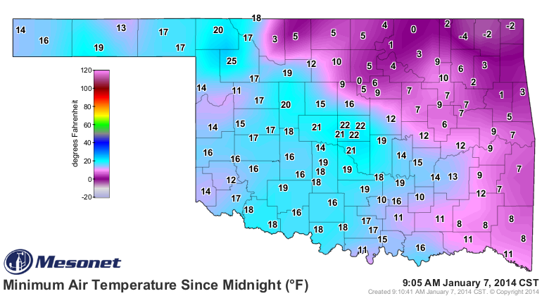
This morning was not quite as bad, but that's all relative to the last few days
because I'd still call this morning NASTY. Nowata, which I've decided to rename
"Icewata" (think the town council will agree?), earned the state's low
temperature prize again with a mark of -4 degrees. Maybe a few more records fell.
We're still looking at Friday and Saturday as a chance to get back close to
"normal," although this ain't gonna be no heat wave ... 40s and 50s.
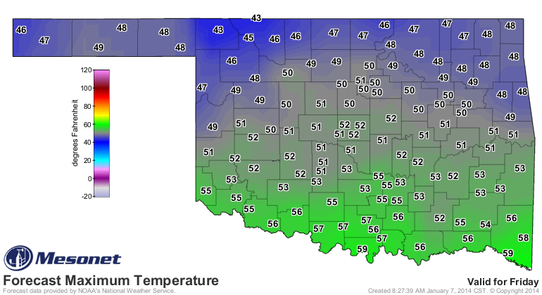
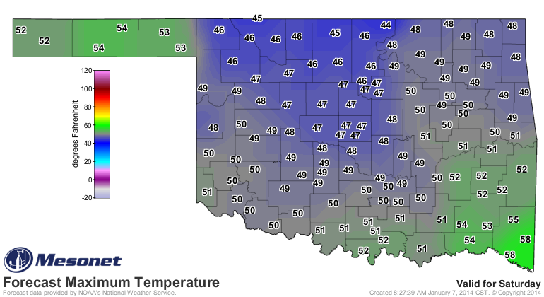
Despite the warm-up, we're still gonna see chances for wintry precipitation off
and on over the next few days, but also just some good old cold rain. I'll let
our friends at the local NWS offices tell the story with pictures.
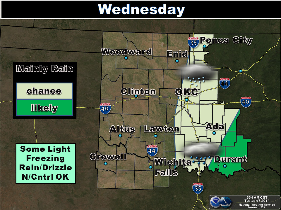
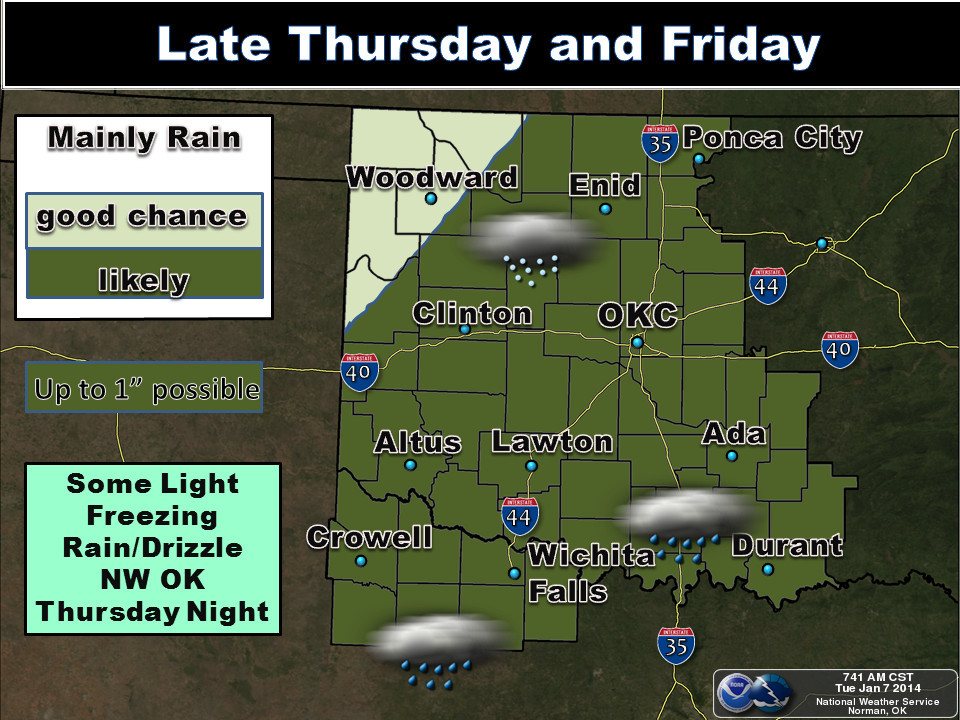
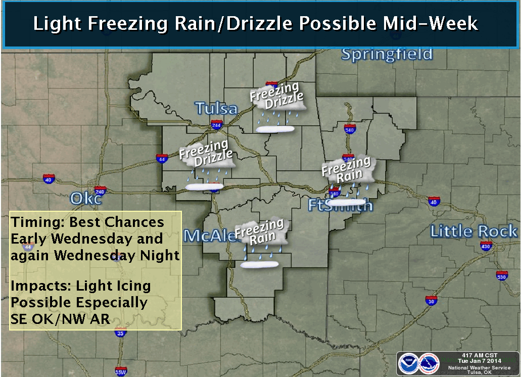
You can see there from the Norman graphic that as much as an inch of rain is
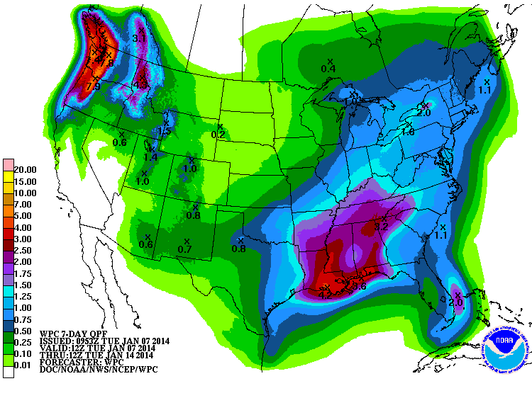
possible from this system, which would be great news if it can fall far enough
west. Here's the 7-day precip forecast that at least gives *some* hope for
SW OK.
So we're nearly out of the latest deep-freeze, and soon enough, this winter is
going to end. Then how will you feel?
Well, warmer, of course.
Gary McManus
State Climatologist
Oklahoma Climatological Survey
(405) 325-2253
gmcmanus@mesonet.org
January 7 in Mesonet History
| Record | Value | Station | Year |
|---|---|---|---|
| Maximum Temperature | 85°F | WOOD | 2006 |
| Minimum Temperature | -19°F | KENT | 2017 |
| Maximum Rainfall | 2.75″ | PORT | 2008 |
Mesonet records begin in 1994.
Search by Date
If you're a bit off, don't worry, because just like horseshoes, “almost” counts on the Ticker website!