Ticker for December 9, 2013
MESONET TICKER ... MESONET TICKER ... MESONET TICKER ... MESONET TICKER ...
December 9, 2013 December 9, 2013 December 9, 2013 December 9, 2013
Deep Freeze 2013
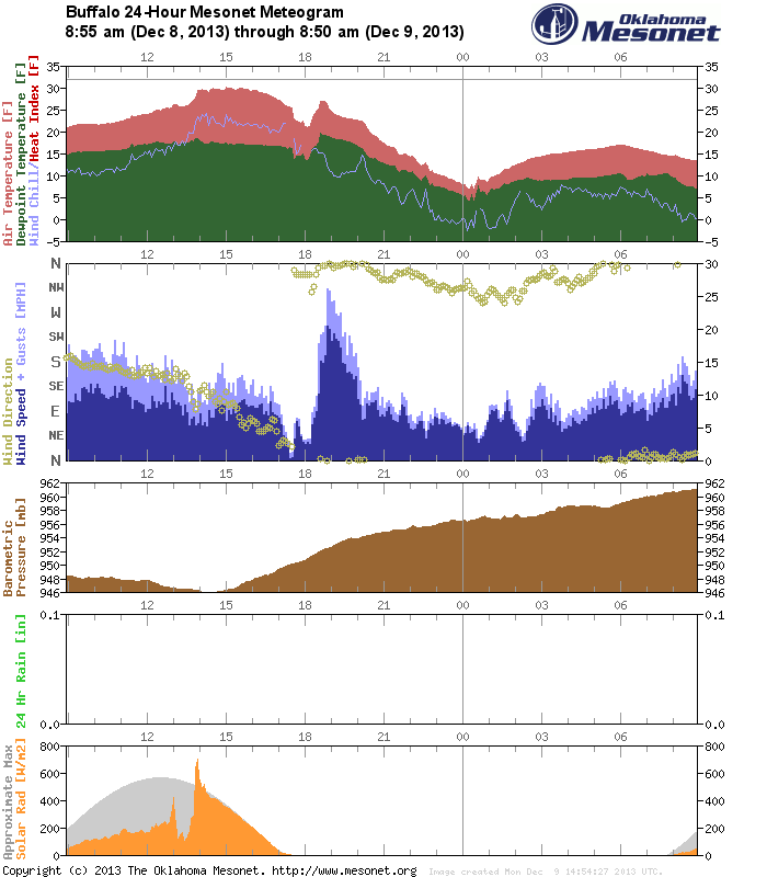
It has now been 125 consecutive hours since the Oklahoma Mesonet sites at Buffalo
and May Ranch have dropped below freezing, and we probably have another 24+ hours
to go.
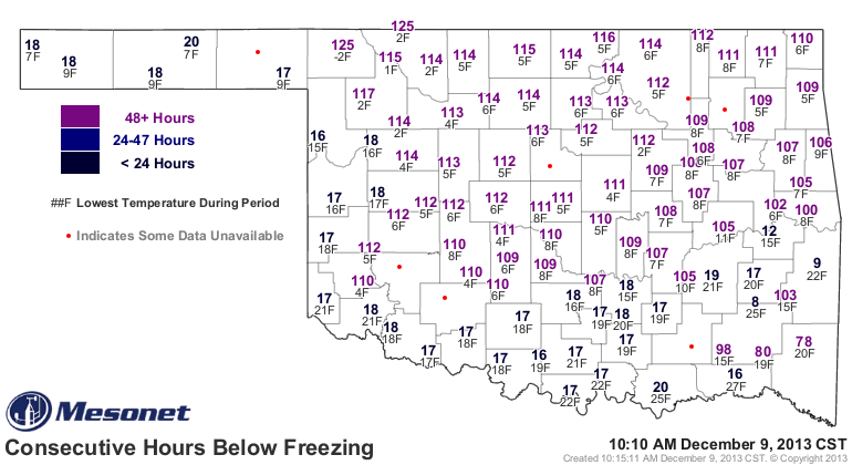
As you can see from that map, those folks in the northwest aren't alone in their
extended stay up around the arctic circle. Buffalo, in addition to being the
best place in the universe, also owns the lowest temperature recorded by the
Mesonet this season at -2 degrees on December 7. Kenton and Altus have both hit
the zero mark, but so far, Buffalo is the only Mesonet site to go beyond that
unfortunate milestone. On the NWS side, the cooperative observers at both Guthrie
and Freedom have also hit -2 degrees (Guthrie on the eighth, Freedom on the
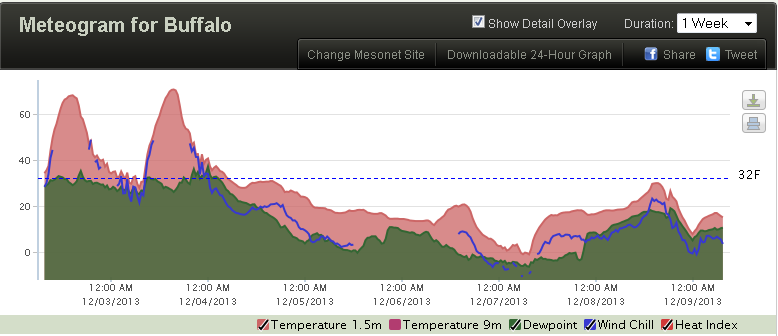
sixth). If you want to see what 125 consecutive hours below freezing looks like,
we can check out the meteogram for Buffalo.
From here to there, we've broken quite a few record, and none of the warm variety.
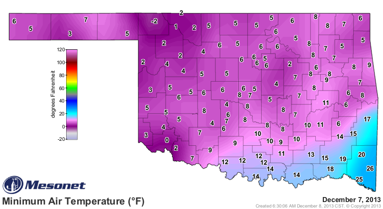
The morning of the 7th was the coldest, as expected, with lows dropping into the
single digits across most of the northwestern 5/6ths of the state.
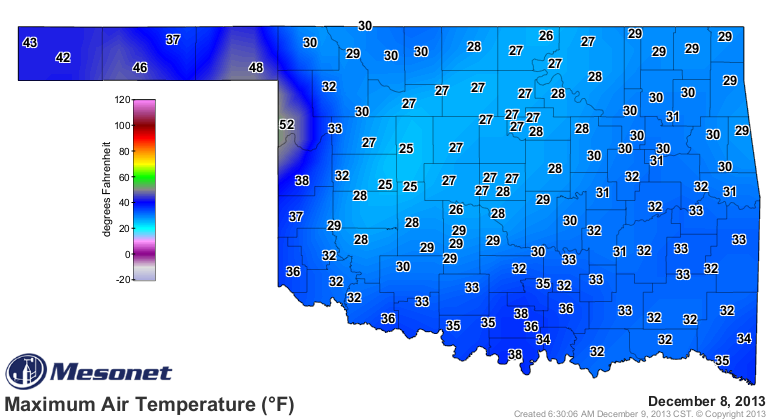
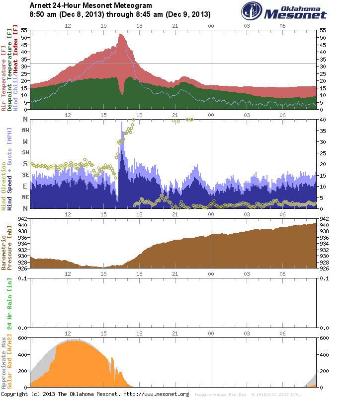
In the oddity department, check out yesterday's high temperature map, specifically
the difference between the high temperatures at Buffalo and Arnett up in the
northwest. I don't know what sort of mojo Arnett had working to get that high
temperature of 52 degrees, but I like the cut of their jib! And the Panhandle
got into the act with some 40s as well. So you had 30 degrees at Buffalo and
a County away
My guess it was mostly due to nearly a full day of sunshine at Arnett vs. a
gradual clearing at Buffalo (solar radiation received is at the bottom of each
meteogram).
As far as a statewide basis goes, nothing too earth-shattering on the extended
cold thanks to an uncooperative SE Oklahoma, which stayed above freezing for
an extended period of time, and the aforementioned heat in the northwest
yesterday. However, December 7th ended up being tied for the 96th coldest day
in state history (again, statewide average basis, highs and lows all averaged
together) with an average of 14.4 degrees. The coldest single day in state
history remains December 22, 1989, with a statewide average of 1.9 degrees.
The only days recently that came in colder than December 7th were February 2nd,
3rd and 10th of 2011 and January 8, 2010, came in right ahead of December 7th
at 14.3 degrees.
-------------------------------------------------------------------------------
Almost-epitaph of the storm
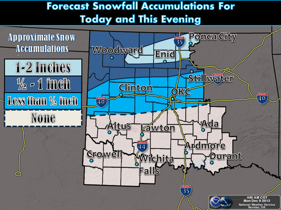
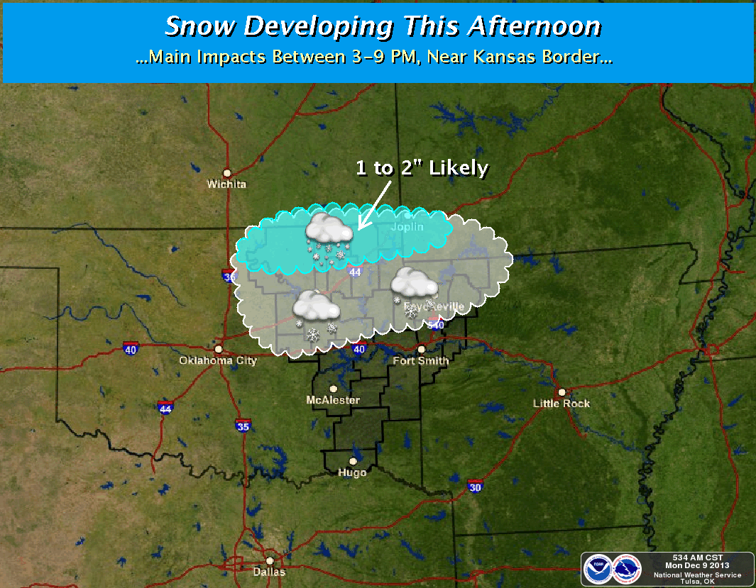
I say "Almost" since it is currently snowing in the northwest, and while that's
not part of last weekend's storm, it's too close for comfort. Here are the
graphics from the local NWS offices concerning today's storm system.
The weekend's storm played out pretty much like expected (kudos to the NWS
forecasters). We did avoid the large-scale ice storm down in southeastern
Oklahoma, but a smaller area did get pummeled pretty hard. It appears Texas took
the brunt of the large-scale storm. According to the Oklahoma Dept. of Emergency
Management, Pushmataha and Choctaw counties were the hardest hit and are
receiving help from the Oklahoma National Guard to help move fallen trees out
of the roadways. In addition, Baptist Disaster Relief is moving chainsaw teams
to Hugo, Antlers and Pocola to help clear county roads and residences of downed
trees and limbs.
Power outages reached a maximum of 9300 homes and businesses at the height of
the storm on Friday, according to OEM. State Dept. of Health reports 247
storm related injuries treated at area hospitals, including 172 falls. The OK
Highway patrol responded to 201 non-injury and 65 injury weather-related wrecks
since 8 a.m. last Thursday, with one fatality.
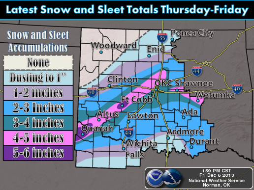
Here are the storm totals from the NWS-Norman office. In their area of
responsibility, southwestern Oklahoma received the highest totals of 5-6 inches.
In the Tulsa area, they had some pretty hefty totals themselves.
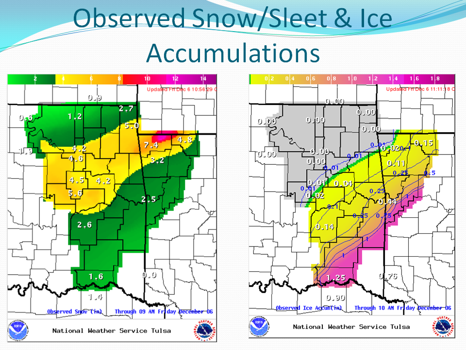
The highest storm total snowfall reading I can find from a NWS cooperative
observer is 7.3 inches at Oktaha, a small town in Muskogee County. Claremore
came in with 5.5 inches and the Tulsa airport measured 4.9 inches. Now these
are still preliminary and no doubt many other stations have yet to report their
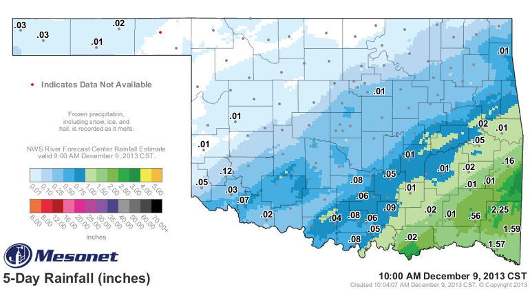
totals. With so much frozen precipitation and so many hours below freezing, we
still have to await the melting for the Mesonet gauges to start to accumulate
precipitation totals, but radar estimated totals show some decent liquid
equivalents across the southeastern half of the state (as well as some actual
measurements of more than 2 inches in the southeast).
Had enough of the cold? YEAH, ME TOO!! It looks like we might see a statewide
thaw begin tomorrow with all areas reaching above the freezing mark for highs.
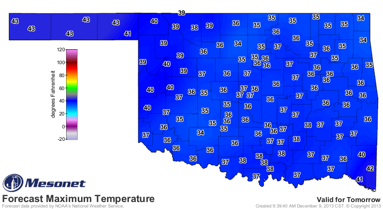
That's pretty much what it looks like for the rest of the week ... highs in the
40s mostly, a few 30s here and there, maybe a 50 or two. Lows will slowly climb
back into the 20s and low 30s ... a bit more seasonable for this time of year.
The REALLY good news is we might go back above normal for a bit later this month,
at least if you believe the CPC 8-14 day temperature probability maps. At least
for the December 16-22 time frame, we see increased odds of above normal
temperatures.
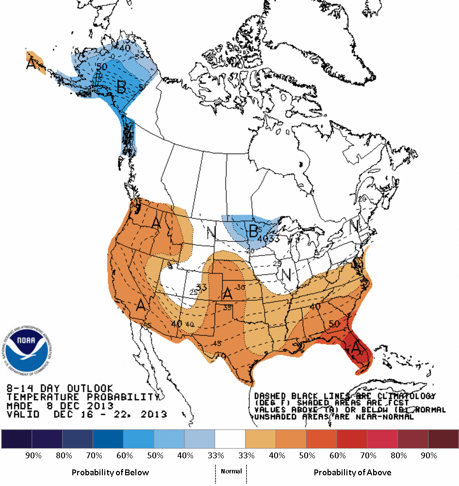
That one is completely computer generated, since it came out yesterday, so we'll
see if the "human-touched" forecast for that time frame looks similar later
today. I'll keep you updated.
The best thing we can do is all hang in there until this worthless cold weather
passes and we're back into the 90s and 100s. Only about 5-6 months away!
Gary McManus
Associate State Climatologist
Oklahoma Climatological Survey
(405) 325-2253
gmcmanus@mesonet.org
December 9 in Mesonet History
| Record | Value | Station | Year |
|---|---|---|---|
| Maximum Temperature | 82°F | BURN | 2021 |
| Minimum Temperature | -7°F | VINI | 2005 |
| Maximum Rainfall | 2.51″ | JAYX | 1999 |
Mesonet records begin in 1994.
Search by Date
If you're a bit off, don't worry, because just like horseshoes, “almost” counts on the Ticker website!