Ticker for November 27, 2013
MESONET TICKER ... MESONET TICKER ... MESONET TICKER ... MESONET TICKER ...
November 27, 2013  November 27, 2013  November 27, 2013  November 27, 2013


Merry Black Friday (Thursday)

To the three people checking e-mail today, I thought I'd show you the latest
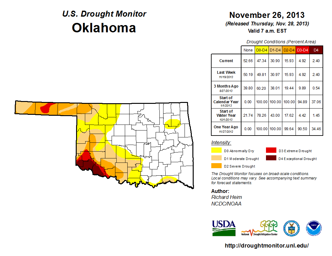
U.S. Drought Monitor map, released a day earlier since tomorrow is Black Friday
(or as I know it ... Thanksgiving).

The latest map once again reflects the precipitation received the previous week
from 6am Tuesday-6am-Tuesday. Many thought there would be major improvements
due to the big snowfalls in the southwest, but from what we could tell, the liquid
equivalents from the 4-12 inches of snow amounted to less than an inch in most
places, and less than a half in in a significant part of those "most places."
That's not really enough to dent a drought that is dominated by both short-term
and long-term impacts. For example, that snow will sit on the ground and melt into
the soil, giving the topsoil a good drink, but it won't percolate very far into
the lower soils, nor will it runoff into farm ponds or Lake Altus-Lugert or
Tom Steed Lake. Therefore, the drought remains unchanged in the southwest.


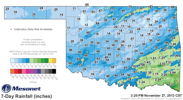
Check out the Mesonet rainfall maps for the last 7 days. It has been warm enough
for all the frozen moisture in those tipping bucket rain gauges to melt, but you
can also see the radar-gauge estimated amounts from the Tulsa RFC, confirming the
widespread 0.25-0.75 amounts from Harmon through Greer and Kiowa counties, and
the lesser amounts surrounding those more generous totals. You can also see
there was actually some pretty good amounts over in the southeast, which is
why you saw more and more of the drought designations disappear in that part
of the state.


So there you have it ... a nice bit of moisture down in the southwest, most
assuredly soaking into the ground as it melts (also evaporating {or sublimating}
away into the air as it basks in the dry air). Definitely something for those
folks to be thankful for.

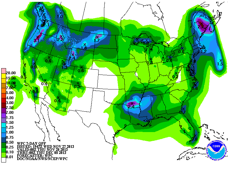
What's next? Well, it appears pretty dry for the next 7 days.


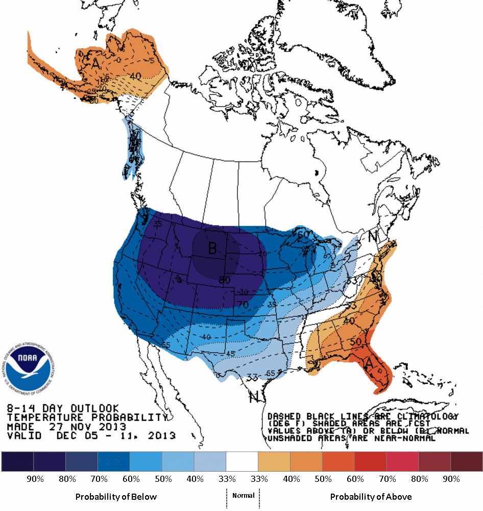
But it also looks like a large pool of cold air could be poised to our north
next week, if not spilling down into the Southern Plains. No hint of moisture
with it yet. This definitely shows increased odds of below normal temperatures,
however.


So there you have it, a turkey of a forecast if you need moisture, but a dandy
for you folks traveling to Grandma's (or Sear's) tomorrow.

From the entire Ticker Staff ... have a great Thanksgiving!

Gary McManus
Associate State Climatologist
Oklahoma Climatological Survey
(405) 325-2253
gmcmanus@mesonet.org
November 27 in Mesonet History
| Record | Value | Station | Year |
|---|---|---|---|
| Maximum Temperature | 87°F | EVAX | 2017 |
| Minimum Temperature | 8°F | KENT | 2019 |
| Maximum Rainfall | 5.50″ | HUGO | 2015 |
Mesonet records begin in 1994.
Search by Date
If you're a bit off, don't worry, because just like horseshoes, “almost” counts on the Ticker website!