Ticker for July 18, 2013
MESONET TICKER ... MESONET TICKER ... MESONET TICKER ... MESONET TICKER ...
July 18, 2013 July 18, 2013 July 18, 2013 July 18, 2013
Hey, drought got better/worse!
The upper-level storm that visited us from the east has now become legendary. I've
seen in meteorological circles say they've never seen such a storm develop and
move from the east in summer, at least of non-tropical origin. And the rain it
provided was even more famous. The epitaph for the storm is now written, and its
inscribed in the Mesonet rainfall maps.

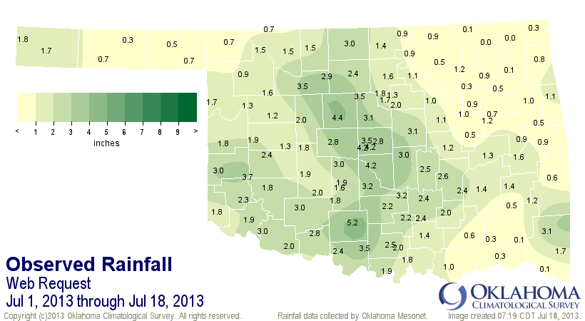
Three inches at Tipton, 2.94 at Erick ... wow! Sorry central Oklahoma, but you
didn't need it quite as much as those folks out west. However, many areas in
central Oklahoma received over 4 inches as well.
Just as the epitaph was written, there were a few epithets in there as well. NO
rain at Vinita. Less than a half inch in much of the Panhandle, northeastern and
southeastern Oklahoma. So not all shared in the bounty. The places where it did
rain combined with those areas where it didn't to give us our 38th wettest July
1-18 on record with a statewide average of 1.67 inches. That's a scant 0.8 inches
above normal for that time period, however. There are a couple of good reasons
for that lack of an impressive statewide total.
1. Those that got rain got a lot of it, but those that didn't get as much, they
got very little.
2. It has been significantly dry through much of mid-June through the first
half of July (the period in question since July 1).
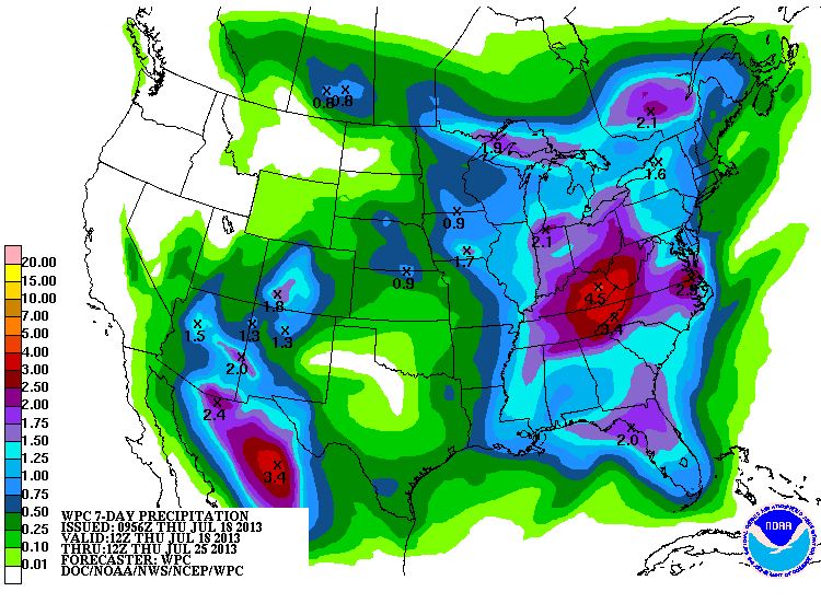
Check out the maps for yourself.
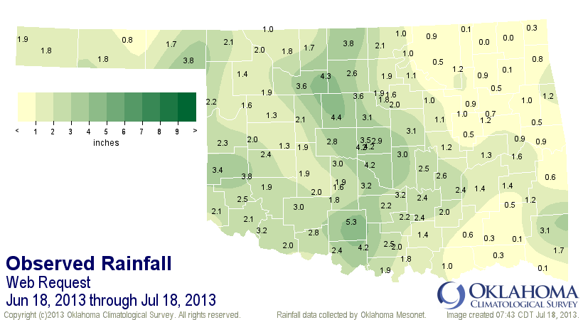
And we can go back to that mid-June period as a final preview before we unveil
today's new U.S. Drought Monitor map. Let's just go back a month. The
statewide average from June 18-July 18 is 1.87 inches, 1.55 inches below
normal and the 19th driest such period since 1921.

Okay, keep that in mind as we look at the new DM. Also remember that we cutoff
the precipitation after 7 a.m. on Tuesday morning for consideration until next
week's map.

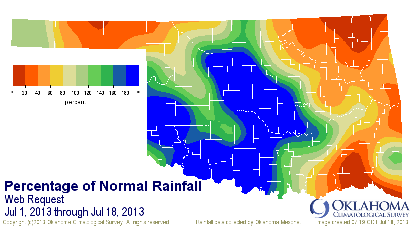
We still see that wonderful drought hole across central and eastern Oklahoma.
But wait, the amount of the state at least in D1-Moderate drought went up
from 51% to 59%? What gives there? Well, to put it simply, it rained a lot
where they needed it the least. However, we did see some easing in southwestern
Oklahoma, where they dropped from D4-Exceptional drought to D3-Extreme drought.
That's the first time since Aug. 7, 2012, that we have not seen D4 in the
southwest. So some great news there.
Now for the bad news, drought actually increased across southeastern and
northeastern Oklahoma. Again, those areas that have missed out on the good rains
since mid-June, and even farther back than that in some cases. Now for some
bad news, the latest U.S. Seasonal Drought Outlook, valid for today through the
end of October, sees drought persisting across Oklahoma, and even developing
in those parts of the state where it's non-existent now.
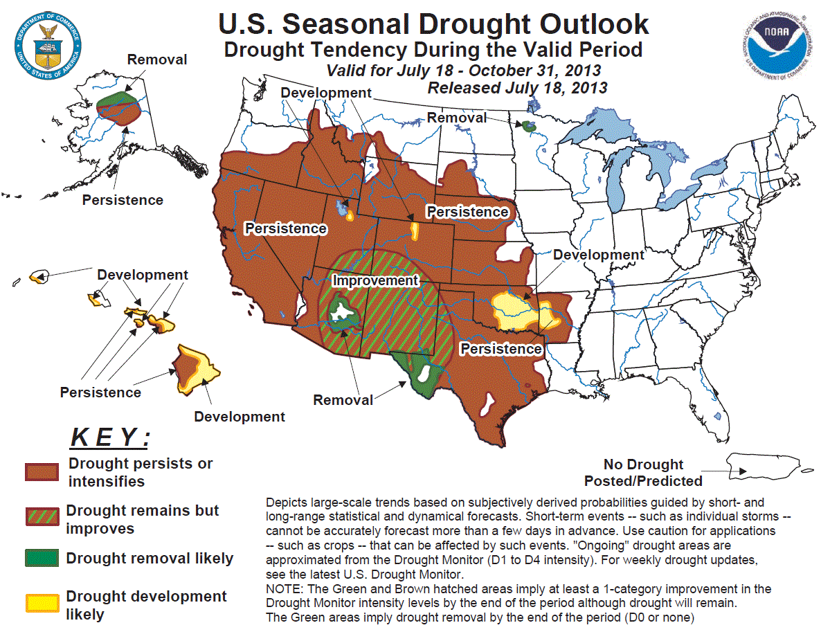
This one seems a bit pessimistic to me, but here is the forecaster's reasoning
this go-round.
"Drought is forecast to persist across the southern Great Plains and
central sections of the Great Plains and High Plains through October
2013. Only a few tenths of an inch of precipitation are forecast into
late July, and the odds generally favor below-normal rainfall from
central Texas northward through southwestern South Dakota until the
end of the month. Neither the 1- nor 3-month (August and August ?
October) forecasts indicate any tilt of the odds away from climatology,
but historically precipitation totals decrease as summer progresses
into autumn, and soil moisture declines more often than not from the
Oklahoma Panhandle northward."
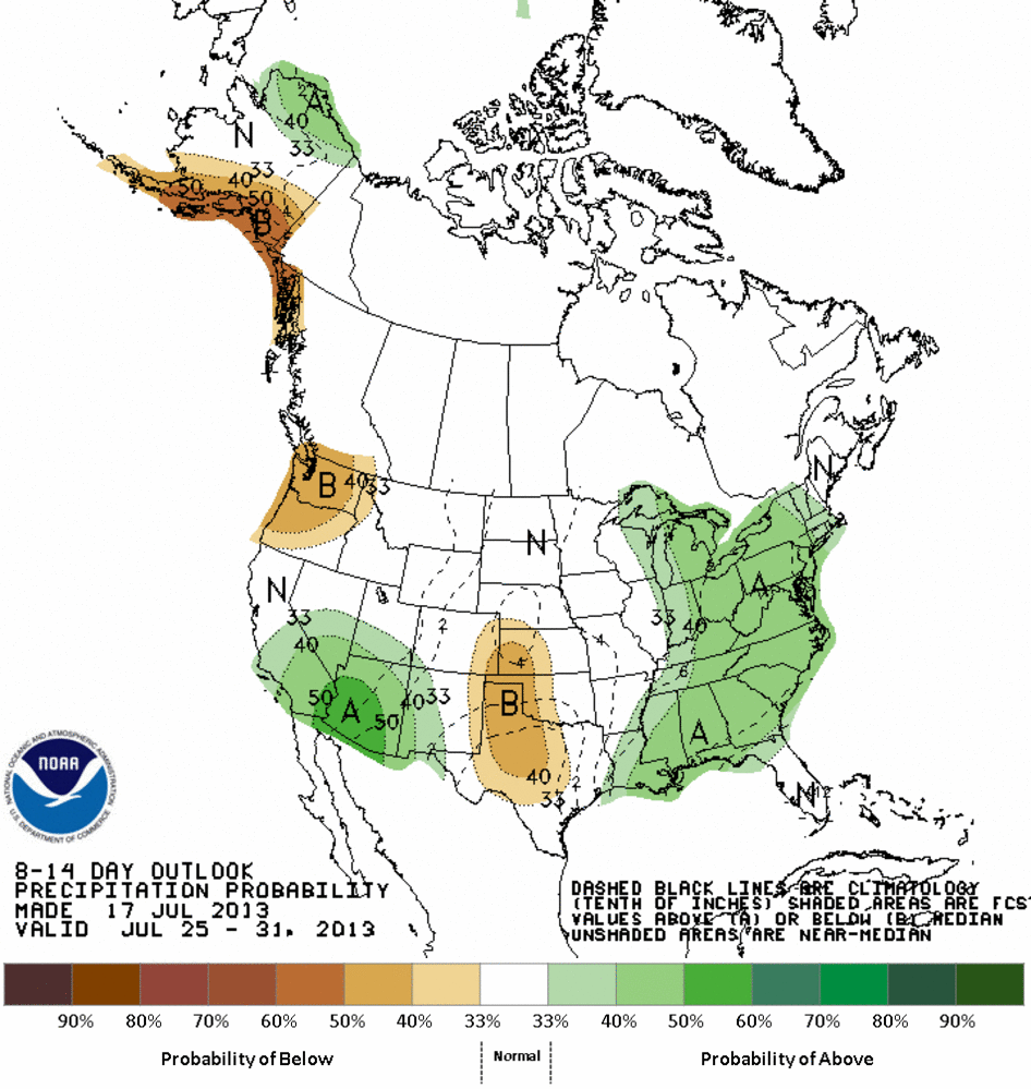
So the 7-day rain outlook looks much more summer-ish, as does the 8-14 day
outlook.
The August-October CPC outlooks don't give us a definitive precipitation
forecast for Oklahoma, but they do indicate warmer than normal conditions are
favored.
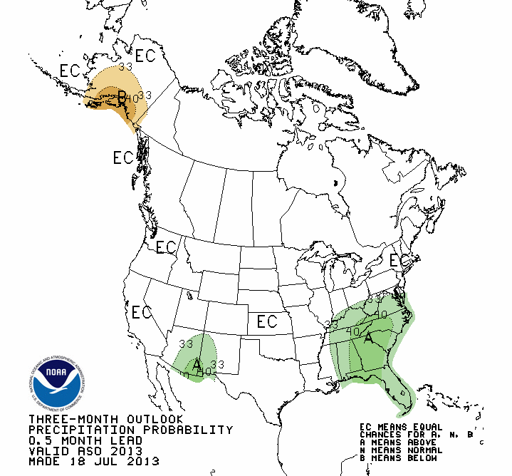
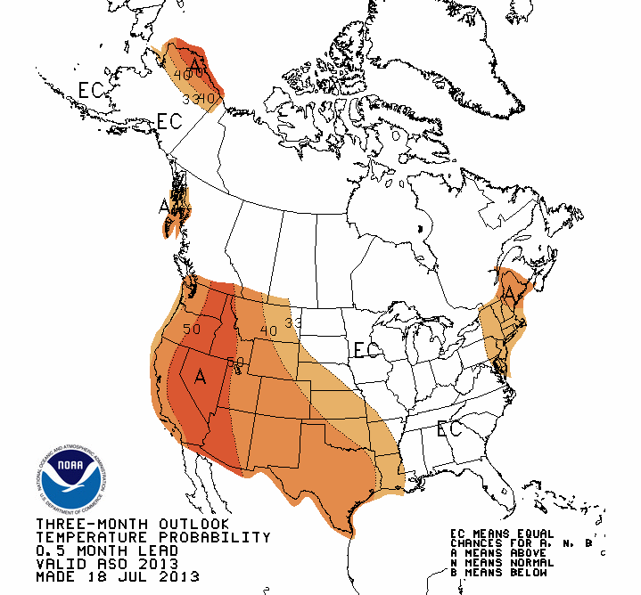
As usual, let me warn you that the "EC-Equal Chances" precip outlook for our
area is not a forecast of normal, but a forecast of equal odds for above-,
below- or near-normal conditions. In other words, a punt. BUT NOT A FORECAST
OF NORMAL!
At any rate, it will be unfortunate should that Seasonal Drought Outlook
verify. It's an indication that this most current storm system was more of an
oddity than a sign of a continued rainy summer.
But hey, Oklahoma weather is chock full of oddities lately. So we should just
kindly inform Mother Nature: "Thank you M'am, may I have another?"
Gary McManus
Associate State Climatologist
Oklahoma Climatological Survey
(405) 325-2253
gmcmanus@mesonet.org
July 18 in Mesonet History
| Record | Value | Station | Year |
|---|---|---|---|
| Maximum Temperature | 110°F | BURN | 2022 |
| Minimum Temperature | 51°F | JAYX | 2009 |
| Maximum Rainfall | 3.17 inches | CHAN | 1997 |
Mesonet records begin in 1994.
Search by Date
If you're a bit off, don't worry, because just like horseshoes, “almost” counts on the Ticker website!