Ticker for December 20, 2012
MESONET TICKER ... MESONET TICKER ... MESONET TICKER ... MESONET TICKER ...
December 20, 2012 December 20, 2012 December 20, 2012 December 20, 2012
Who's enjoying the gentle breeze?
Are you like me (careful, haven't we gone over this before?), did you enjoy going
out late in the evening for the gentle Oklahoma breeze? The crisp clean blue
skies and the mouthful of southwest Texas? Oh, we'll get to the drought in a
second, but the current story is the WIND! I'm not sure who ordered the Code
Red, but I want answers ... I WANT THE TRUTH! You can see we had wind gusts up
to 63 mph at Weatherford last night, and then up to 61 mph at Medicine Park after
midnight (as recorded by the Mesonet).
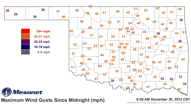
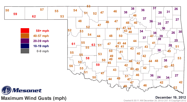
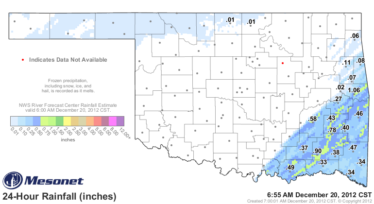
This is all associated with the system that brought a blowing snow to northern
Oklahoma and storms with a tornado watch to eastern Oklahoma. That brought far
southeastern Oklahoma a nice little half-inch to about an inch of rain.
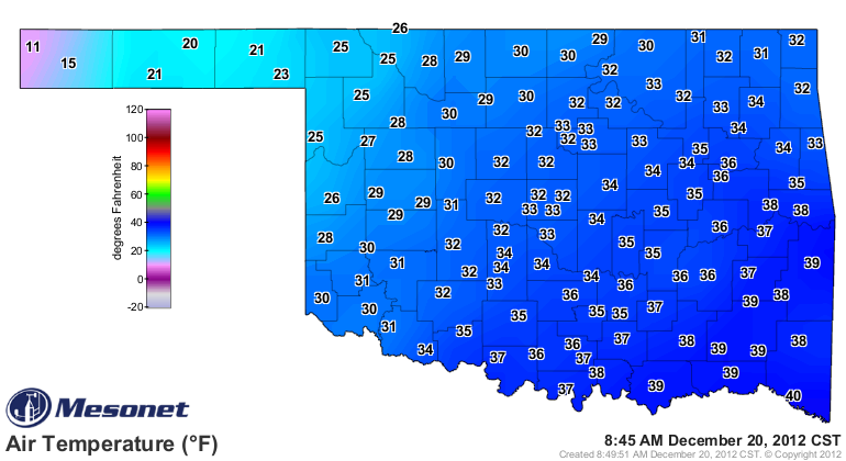
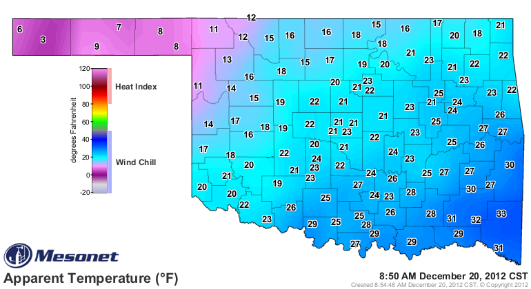
The big story now (other than the wind) is the cold air filtering in after the
front. Temperatures plunged into the single digits at Kenton (8 degrees) and have
dropped into the 20s and 30s elsewhere.
Add the wind and it's colder than a raccoon's liver (just making stuff up now)
out there!
-------------------------------------------------------------------------------
Gee, thanks!
On to drought, and the U.S. Drought Monitor left us with a lump of coal in
our stocking right before Christmas. The percentage of Extreme (D3) drought
increased just a bit and we now have 93% of the state covered by Extreme-
Exceptional (D3-D4) drought.
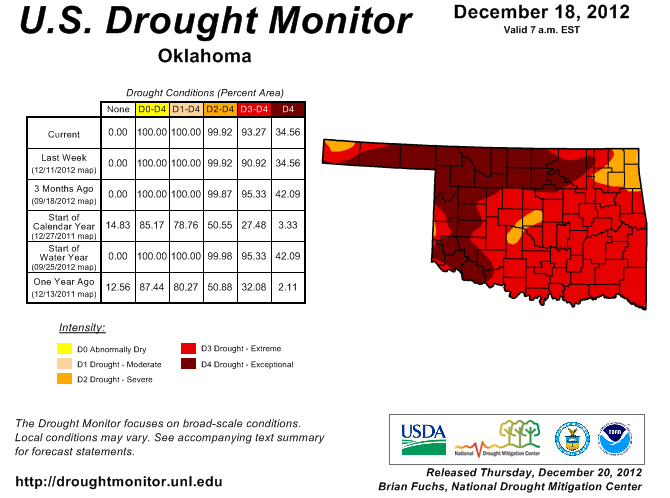
So the same old drought picture there. The rainfall last night in the southeast
might have some impact (doubtful) on next week's map. Note, however, that Hugo
Lake is now down to 38% of the conservation pool, and Broken Bow is at 68%. That
is a slight improvement for both, but VERY slight. The rains last night brought
the statewide average for December up to 0.33", about an inch below normal and
the 13th driest Dec. 1-20 since 1921. The southeast Climate Division (CD9) has
an average of 0.74", 1.88" below normal (or about 28% of normal) and the 10th
driest on record. So even with the rain, they remain much below normal.
-------------------------------------------------------------------------------
The Ghost of Drought's Future
Well, a lot's hinging on this storm system that's expected to flirt with the
state on Christmas Day, or thereabouts. You can see the HPC are still seeing
some beneficial moisture for the state on their 7-day precipitation forecast.
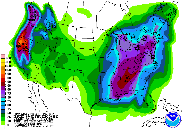
Now that can come in the form of snow, rain, or we could get left out
completely. I'm not trying to be coy, that's just how inconsistent the weather
forecast models have been. As has been the case lately, however, expect lots of
wind, probably some blowing dust, and lots of extreme fire danger thrown in.
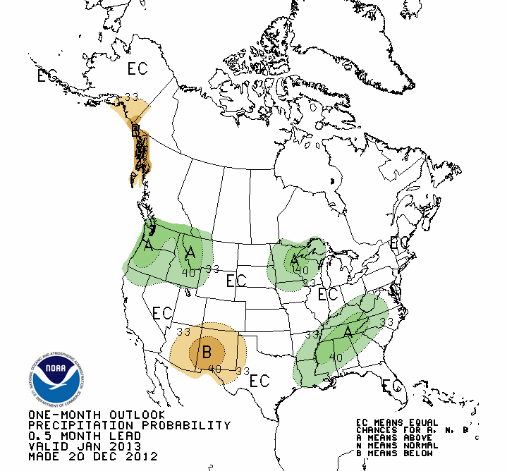
As we look farther ahead, the CPC punts on the outlooks for both temperature
and precip into January for the state, with both maps showing Oklahoma under
the dreaded "EC" designation. The "EC" stand for "Equal Chances," which means
the forecaster sees no large-scale climate influences impacting the state, and
therefore we will see equal chances of above-, below- or near-normal temperature
and precip amounts. The usual caution applies: THIS IS NOT A FORECAST/OUTLOOK
FOR NORMAL CONDITIONS!!

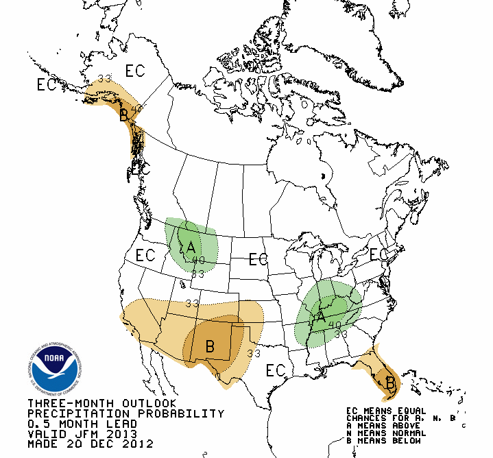
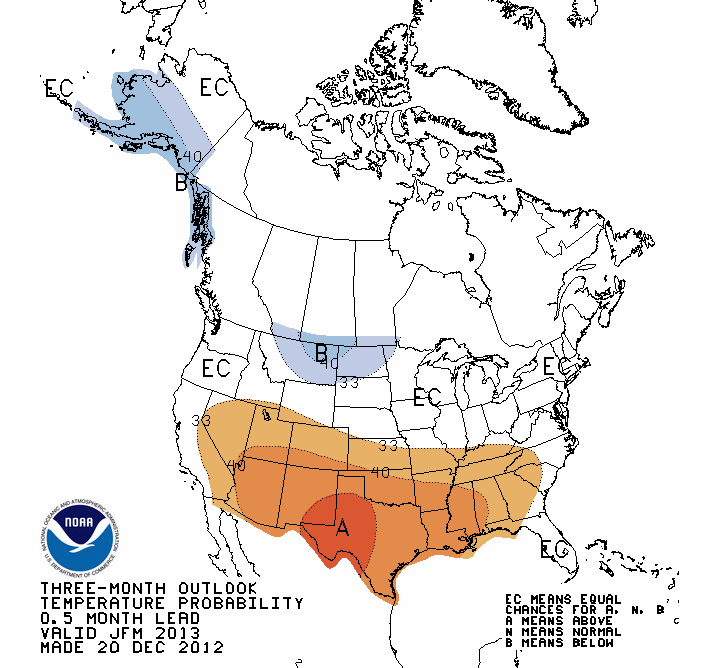
The January-March period is a difference matter. The CPC paints all of Oklahoma
and much of the southern tier of the U.S. with increased odds of above normal
temperatures for that 3-month period. Western Oklahoma also sees increased odds
of below normal precipitation, so not a good sign for that part of the state.
Well BAH HUMBUG to you too! I didn't make the forecast.
You will continue to see that warm pattern for the Southern Plains as we get
farther into the winter and spring if we don't see soil moisture improve. As
we've talked about many times here on the Ticker, as the sun gets higher in
the sky, the drier soils will allow for more heating (due to less evaporation
and possibly less vegetation). The same condition is the reason for the
possible below-normal precip in the Southern Plains. The lack of soil moisture
means a lack of local moisture available for storms to tap into.
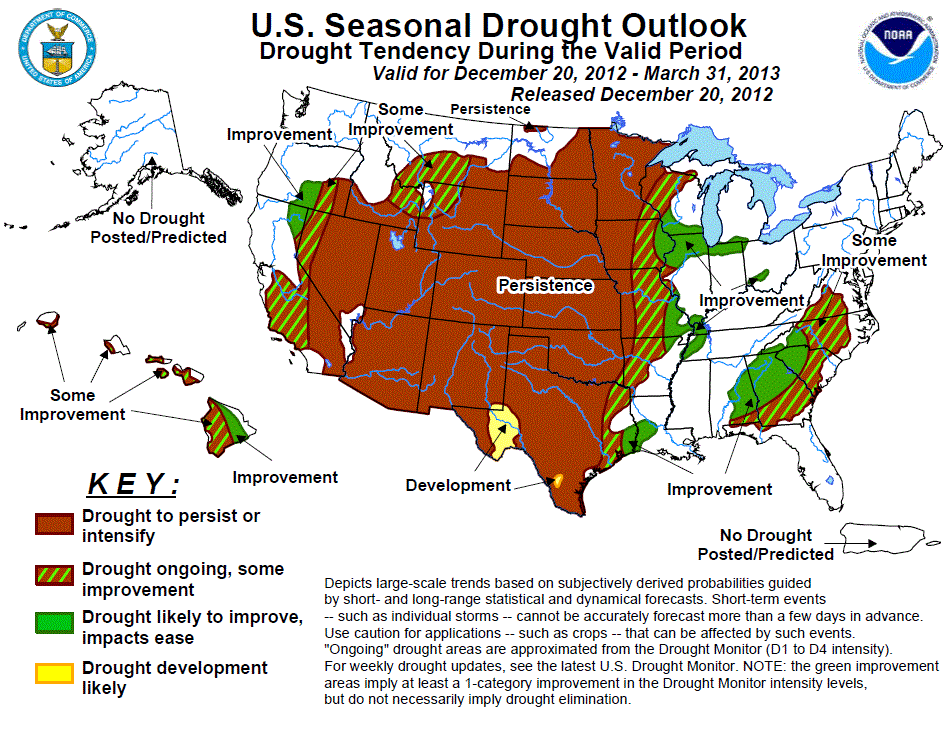
So all of that paints a dismal January-March U.S. Seasonal Drought Outlook
map. Once again, drought is expected to either persist or intensify for the
state through March.
Their explanation follows what we've been telling you for a couple of months
now ... it's dry during the winter, so the precip amounts have to be quite a
bit above normal to impact this type of drought.
"The CPC 8 to 14 day outlook maintains enhanced odds of above average
precipitation for most of the Plains outside of the southern high
Plains, but below median or near median precipitation amounts are
favored for the remainder of the three month period. The winter and
early spring months are a dry time of year for the Plains, therefore,
impacts from precipitation anomalies are expected to be smaller than
during the warmer months. Based on these considerations, general
persistence of drought is expected across the Plains."
Although the skill goes down quite a bit (it ain't exactly great to begin with),
the precip outlook for April-June is a bit worrisome.
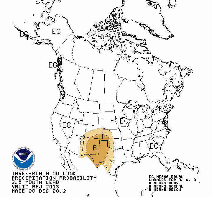
The increased odds of below normal rainfall for the western areas of the state
would be the third such loss of good spring rainfall in a row, and would be
devastating should that come to pass.
It is absolutely vital to our odds of stopping this drought at sub-three year
levels that we see at least a normal spring rainy season in the state.
Gary McManus
Associate State Climatologist
Oklahoma Climatological Survey
(405) 325-2253
gmcmanus@mesonet.org
December 20 in Mesonet History
| Record | Value | Station | Year |
|---|---|---|---|
| Maximum Temperature | 83°F | WAUR | 2010 |
| Minimum Temperature | 1°F | EVAX | 2022 |
| Maximum Rainfall | 3.31″ | DURA | 1997 |
Mesonet records begin in 1994.
Search by Date
If you're a bit off, don't worry, because just like horseshoes, “almost” counts on the Ticker website!