Ticker for February 23, 2012
MESONET TICKER ... MESONET TICKER ... MESONET TICKER ... MESONET TICKER ...
February 23, 2012 February 23, 2012 February 23, 2012 February 23, 2012
No change on the Drought Monitor
Very little rain for a week during the cool season normally means very little
change in drought, and that's exactly what we saw reflected in this week's U.S.
Drought Monitor map.
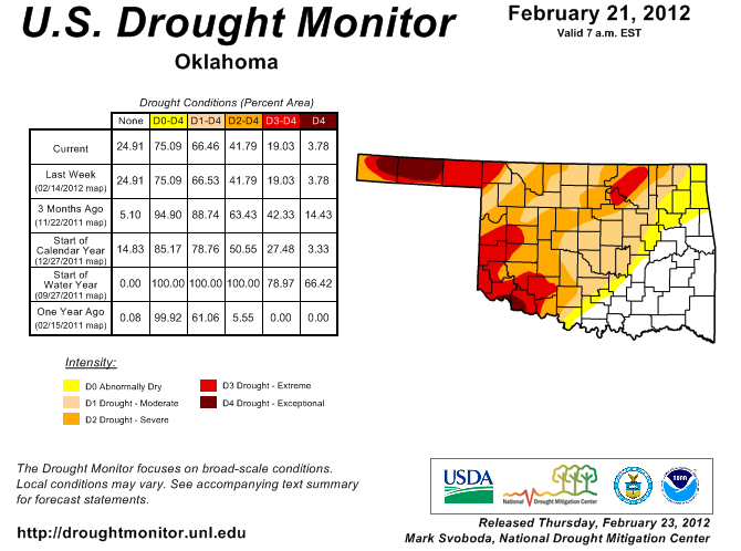
The worst of the dry conditions are still depicted in the Panhandle and southwest.
The spot of extreme (D3) drought remains in the northeast where reservoir levels
continue to be worrisome. I talked with a few officials in the Panhandle to ask
for some boots-on-the-ground reports and they affirmed the depiction in that area.
The gist of the conversation was "Yes, it's bad out here, but it will get a lot
worse if we don't see rains during the warm season."
That's the 800 pound tumbleweed waiting around the corner with the beginning of
spring (at least climatologically) about a week away. Once we reach the warm
season, the impacts - or lack thereof - will give us a better idea of how we came
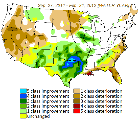
through this cool season. One thing is evident ... this cool season's rainfall
was a near miracle for the Southern Plains and Oklahoma, as evidenced by the
Drought Monitor Change map for the water year thus far (Sep. 27, 2011-Feb. 21,
2012, to be exact).
************************************************************
One of the other things that occurs during the transition period between the
cool and warm seasons is fire danger. That period in February and March before
the vegetation comes alive and starts to green up again is Oklahoma's most
important fire danger alert time. Climatologically speaking (slow, monotone
and dull ... you want fast, talk to meteorologists), it's the time of the year
when the temperatures are starting to head into the 60s and 70s a bit more
often, the air is still relatively dry quite often with relative humidity at
times less than 20 percent and the wind speeds are on the up-tick.
Dormant/dead vegetation, warm temperatures, low relative humidity and lots of
wind ... hmmmm, sounds like today! That's why Most of Oklahoma southeast of the
I-44 corridor is under a Red Flag Fire Warning from the National Weather
Service.
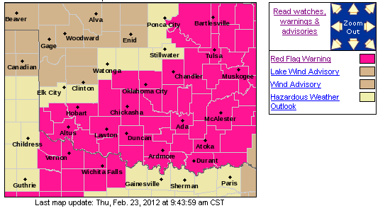
Northwestern Oklahoma gets the wind advisory behind the cold front since their
temperatures will remain in the 50s and their relative humidity won't be quite
as low. Plenty of wind though.
A great place to track wildfire danger is the Mesonet's own OK-FIRE program at:
http://okfire.mesonet.org/
Gary McManus
Associate State Climatologist
Oklahoma Climatological Survey
(405) 325-2253
gmcmanus@mesonet.org
February 23 in Mesonet History
| Record | Value | Station | Year |
|---|---|---|---|
| Maximum Temperature | 91°F | WAUR | 2017 |
| Minimum Temperature | -2°F | BOIS | 2022 |
| Maximum Rainfall | 3.61 inches | EUFA | 2018 |
Mesonet records begin in 1994.
Search by Date
If you're a bit off, don't worry, because just like horseshoes, “almost” counts on the Ticker website!