Ticker for February 16, 2012
MESONET TICKER ... MESONET TICKER ... MESONET TICKER ... MESONET TICKER ...
February 16, 2012 February 16, 2012 February 16, 2012 February 16, 2012
Pawnee County turns red
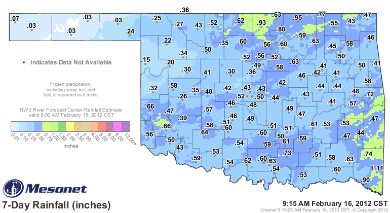
There is little change in the drought map for this week. The bit of snow and rain
we had since last Tuesday was not really enough to give us a widespread intensity
change. Liquid precipitation equivalents across the state were generally in the
half-inch range, although a few places did get close to an inch or so. Here are
the moisture totals that we had to consider and also the Drought Monitor map
itself.
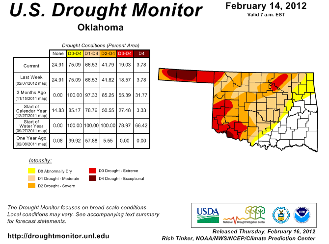
The only noticeable change was an increase in intensity up in Pawnee County. The
NWS office in Tulsa brought a rather precarious water supply problem to the
attention of the Drought Monitor author that required a bit of a downgrade. As
detailed in Tulsa media, Lone Chimney Lake in Pawnee County is the main potable
water supply for 16,000 people in the surrounding area. Pawnee Rural Water
District 2 officials say it's the lowest they've seen the lake in 32 years, and
managers at the lake were worried the water supply would be gone by May 1. A
rain of about 2 inches gives those managers a reprieve until the end of the
summer, by their estimates.
I've detailed northeast Oklahoma as a problem area in recent months, since that
part of the state has continued to miss the rains other areas have enjoyed.
That's how this drought has operated for the past year and a half ... relief
comes to parts of the state and mysteriously remains absent from others. You
can see from the 30- and 60-day rainfall maps exactly what's (not) going on.
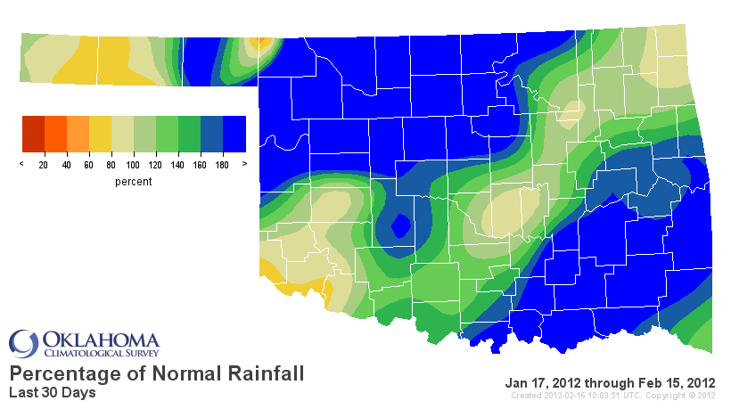
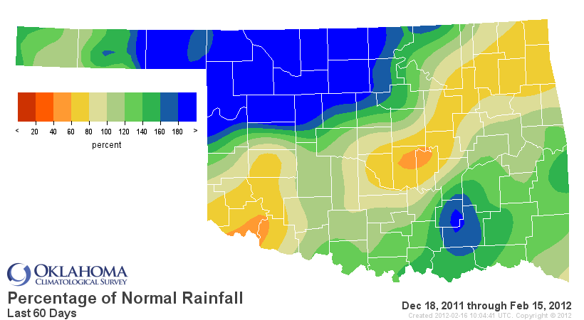
Greater than normal precipitation totals in the southeast and northwest are
separated by a not-so-abundant strip from the southwest through the northeast.
Extend that back to the period drought relief started around the first of
October (coinciding with the start of the water year) and you see the same
pattern.

That pattern is exactly why long-term hydrological concerns remain with Skiatook
Lake in Osage County still at 63% of capacity, in addition to the aforementioned
problems in Pawnee County. Follow that strip down to the southwest and you see
scattered yet similar problem ... Lake Thunderbird in Cleveland County down to
74% full and Lake Altus in Greer and Kiowa Counties at a dismal 18% of capacity.
Canton Lake in Blaine County, a major water supply to Oklahoma City, rose to
35% of capacity after recent moisture, up from 26% of capacity previously.
The concern is not immediate, at least for the water supply. The concern grows
considerably, however, if those levels do not increase before the warm season.
At that point, increased sunlight, heat and consumption can place more demand
than the supply can handle if more moisture fails to arrive.
That's when 16,000 people in northeast Oklahoma go from concerned to panicked.
With La Nina fading, there is a pretty good vibe that the rains will return
for other parts of the state. This winter's version of La Nina has certainly
been kind to parts of the state, taking southeastern and south central Oklahoma
from exceptional drought to surplus moisture in the matter of 3-4 months.
One cautionary note from the NWS' Climate Prediction Center concerning La Nina:
"Because the strength of impacts in the United States is not necessarily
related to the exact strength of La Ni?a in the tropical Pacific, we
expect La Ni?a impacts to continue even as the episode weakens."
Hopefully that's sooner rather than later, especially for the Panhandle and the
I-44 corridor.
Gary McManus
Associate State Climatologist
Oklahoma Climatological Survey
(405) 325-2253
gmcmanus@mesonet.org
February 16 in Mesonet History
| Record | Value | Station | Year |
|---|---|---|---|
| Maximum Temperature | 85°F | HOLL | 2011 |
| Minimum Temperature | -22°F | NOWA | 2021 |
| Maximum Rainfall | 3.37 inches | TALI | 2008 |
Mesonet records begin in 1994.
Search by Date
If you're a bit off, don't worry, because just like horseshoes, “almost” counts on the Ticker website!