Ticker for February 14, 2012
MESONET TICKER ... MESONET TICKER ... MESONET TICKER ... MESONET TICKER ...
February 14, 2012 February 14, 2012 February 14, 2012 February 14, 2012
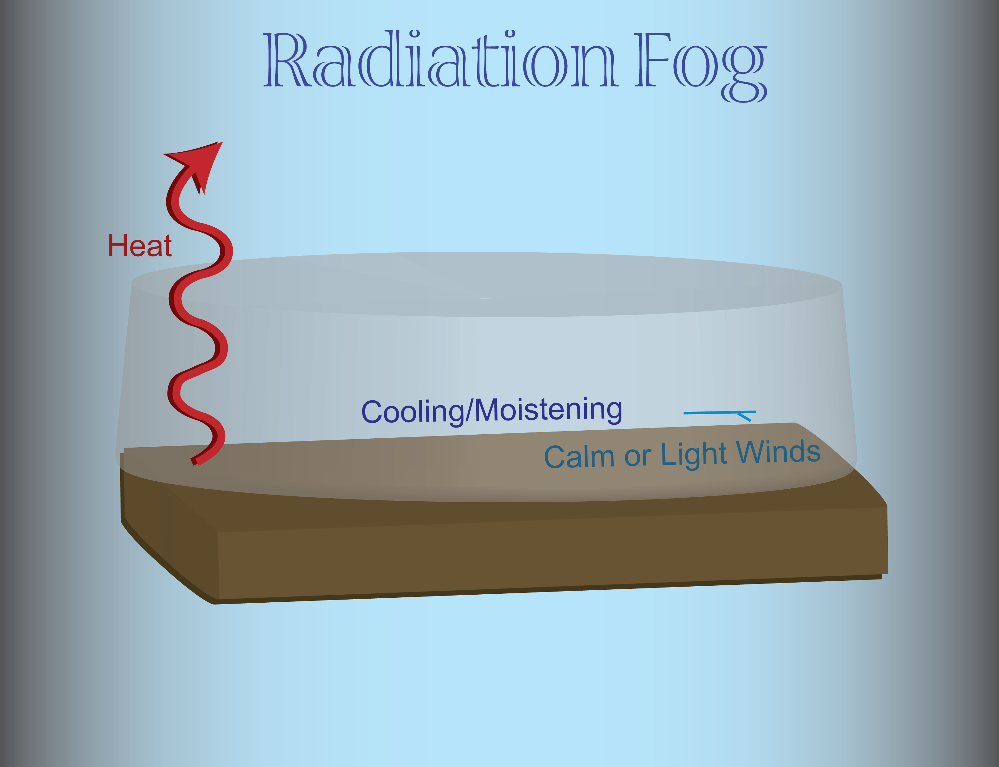
Anatomy of a driving disaster -- freezing fog
Judging by the pictures on the TV, driving conditions this morning are worse than
yesterday despite the lack of snow. The culprit ... freezing fog, and the
Oklahoma Mesonet is the perfect tool to track where the conditions are ripe for
trouble. Start with the snowfall we had Sunday night into Monday morning, a warm
(relatively) southerly wind yesterday, and lots of melting snow. That provided
a very moist low-level surface layer to work with. Then you add clear skies and
light winds overnight. That allowed the surface to radiate its heat upwards,
effectively cooling the surface layer of air. Eventually, that layer of air
reached its condensation point (or dewpoint). Saturated, water vapor began
condensing onto small particles in the air known as "condensation nuclei."
Eventually, a cloud forms and voil?, you have fog. This type of fog is known
as "Radiation Fog" thanks to its formation by radiational processes.
So to go through it again:
1. Light winds prevent any of that heat radiating to space to mix back down
towards the surface, and the surface is allowed to cool quite effectively.
Light winds are a key component in the formation of radiation fog (and also
keeping it around). Check out this map of Mesonet measured winds.
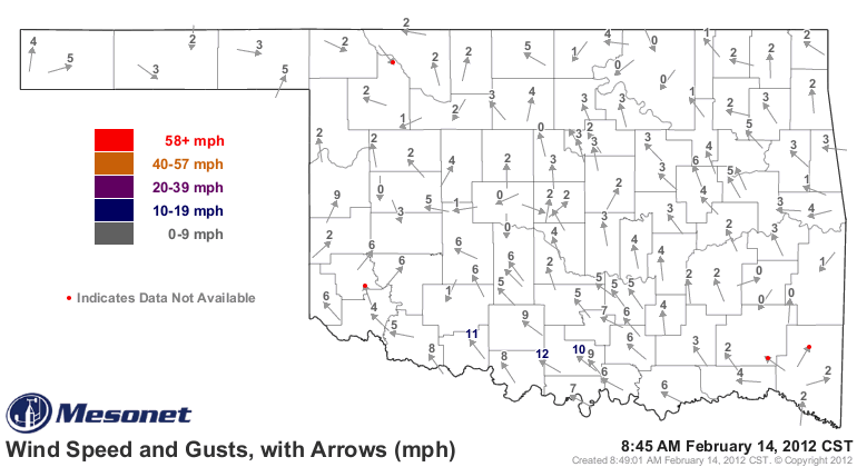
Keep track of the winds here:
http://www.mesonet.org/index.php/weather/map/wind_speed_gusts_with_arrows/wind
2. The air temperature cools to its condensation point (or dewpoint). The
Mesonet's Dewpoint Depression map is great for that. This map displays the
difference between the air temperature and the dewpoint temperature. When those
values reach zero, the air becomes saturated and water can then begin to
condense.
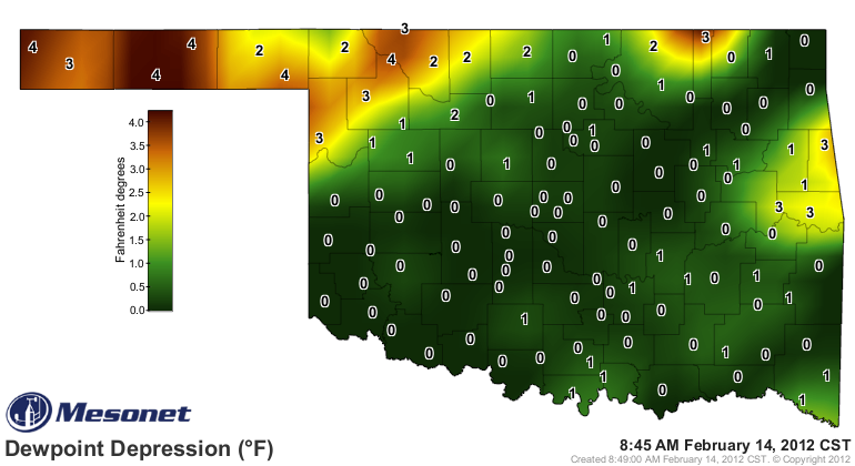
Track it here for yourself:
http://www.mesonet.org/index.php/weather/map/dewpoint_depression/dewpoint_humidity
3. The Relative Humidity where the air temperature has reached its dewpoint
will be 100%.
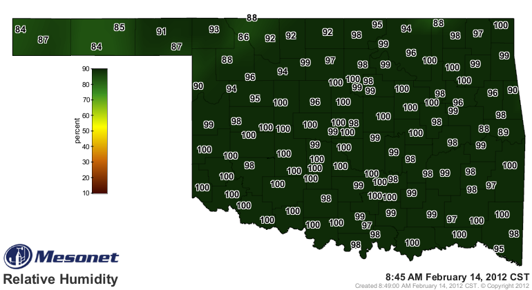
Track the Relative Humidity here:
http://www.mesonet.org/index.php/weather/map/relative_humidity/dewpoint_humidity
4. Now for the final ingredient ... temperatures below freezing. If the air is
at the freezing point or below, the fog that does form will freeze on exposed
surfaces (such as roads), and a full-fledged freezing fog event is born. The
Mesonet's air temperature map shows air temperatures across the state.
Wherever you see 32 degrees or below, watch out!
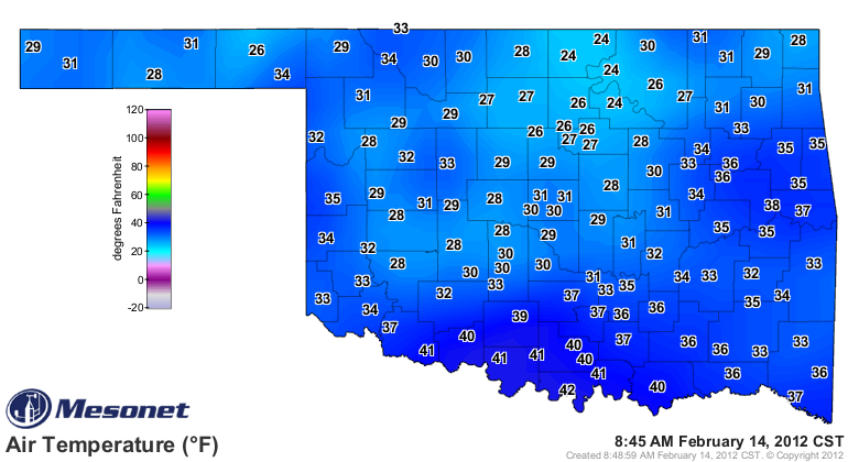
You can track the air temperature here:
http://www.mesonet.org/index.php/weather/map/air_temperature/air_temperature
Low-lying areas can be colder than the surrounding terrain as that colder and
more dense air sinks to the lowest available point, so even an above normal
reading on the map can be misleading.
As the sun climbs higher in the sky and starts to warm things up, the air will
start to mix a bit and the temperature will rise above the condensation point.
At that point, the fog will start to "burn off" as the water droplets evaporate
back into the air.
At least you can get some traction on snow, and see it a little better. Freezing
fog is a whole other animal. Give me snow any day.
Gary McManus
Associate State Climatologist
Oklahoma Climatological Survey
(405) 325-2253
gmcmanus@mesonet.org
February 14 in Mesonet History
| Record | Value | Station | Year |
|---|---|---|---|
| Maximum Temperature | 84°F | FREE | 2018 |
| Minimum Temperature | -18°F | KENT | 2021 |
| Maximum Rainfall | 3.30 inches | MTHE | 2017 |
Mesonet records begin in 1994.
Search by Date
If you're a bit off, don't worry, because just like horseshoes, “almost” counts on the Ticker website!