Ticker for September 1, 2011
MESONET TICKER ... MESONET TICKER ... MESONET TICKER ... MESONET TICKER ...
September 1, 2011 September 1, 2011 September 1, 2011 September 1, 2011
Record August Puts Exclamation Point on Hottest Oklahoma Summer
To get a sense of the state?s legendary heat waves of its past, Oklahoma?s
youngest generation would normally turn to the stories of parents, grandparents
or great-grandparents. Tales of those summers from the 1930s, 1950s and even 1980
seemed as dated as rotary phones or changing the television channel by hand. They
will no longer need to ask older generations about harsh summers, however. They
now have their own stories to tell, and theirs will be from the hottest of them
all ? the summer of 2011.
According to data from the Oklahoma Mesonet, the state?s climatological summer ?
June 1 through August 31 ? ended with a statewide average of 86.8 degrees,
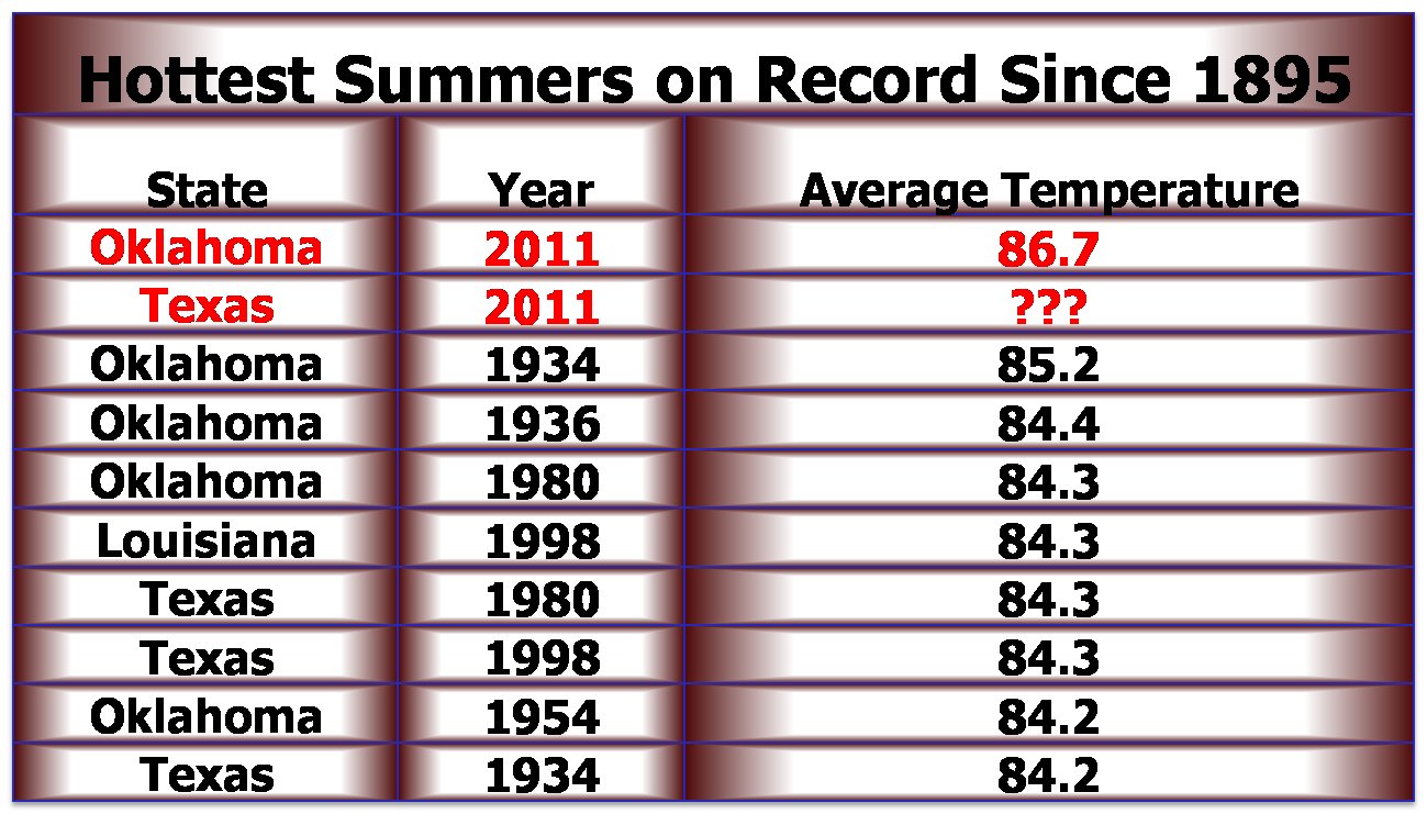
obliterating the previous state record of 85.2 degrees from the summer of 1934.
In fact, that previous 1934 mark was the warmest summer on record for any state
since records began in 1895. While Texas? final summer statistics are still
preliminary, it is known that they also surpassed that 1934 record. It may take
weeks before the new record holder is known, however. The statewide average
high temperature through the summer was 100.5 degrees, topped by southwestern
Oklahoma?s average high of 104 degrees. The highest temperature during this
summer was 115 degrees, recorded in June at Erick and Hollis and in August at
Wilburton and Wister. Oklahoma City smashed its record for hottest summer with
an average of 87.5 degrees, besting the previous mark of 85.9 degrees set in
1934 and 1980. Grandfield?s three-month average of 92 degrees led the state
with Kenton the coolest at 79.5 degrees.

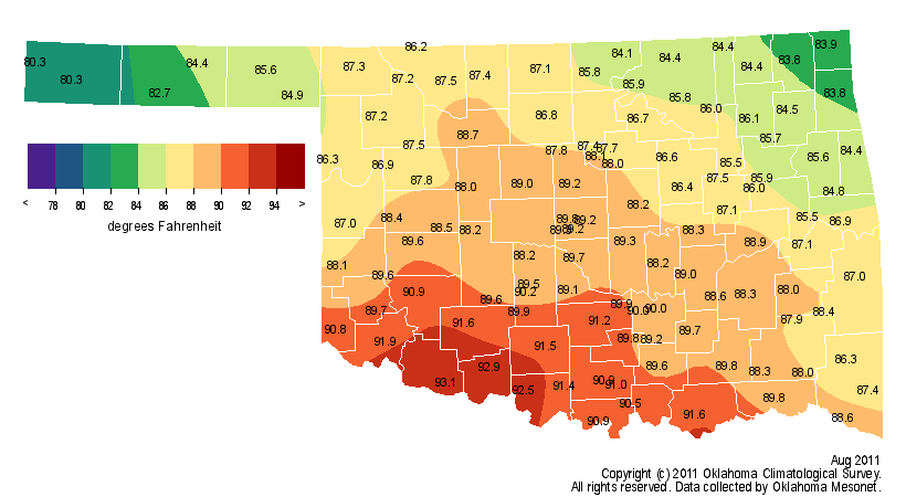
August put the final touches on the momentous 2011 summer. The statewide
average temperature was 87.7 degrees, 7.3 degrees above normal and the warmest
August on record for Oklahoma. The previous record was 87.2 degrees from 1936.
Southwest Oklahoma, the area hit hardest by the drought and heat, had an
average temperature of 91 degrees, 9.2 degrees above normal. That tops the
previous warmest summer for that region by nearly 3 degrees. The average high
temperature for the month in that corner of the state was 105 degrees.
The heat has not been confined to the climatological summer?s boundaries. The
Oklahoma Mesonet site at Grandfield recorded a high temperature at or above 100
degrees an astounding 97 times for the year from April 18-September 1. The
previous high count for one year was 86 days by Hollis during the summer of
1956. Several other locations have exceeded the previous record this year.
Oklahoma City surpassed its own record of 50 days at or above 100 degrees with
59 days through September 1.
 (through yesterday)
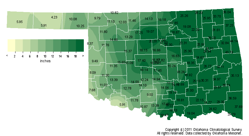
The heat has been fed by extreme drought that began nearly a year ago. The
statewide average precipitation total from October 1, 2010-August 31, 2011,
finished at 18.59 inches, 14.29 inches below normal and the third driest such
period on record. That 11-month period was the driest on record for the
Panhandle, north central, west central and southwestern Oklahoma. The Oklahoma
Mesonet sites at Boise City, Grandfield, Goodwell and Hooker all recorded less
than 6 inches of rainfall since October 1.
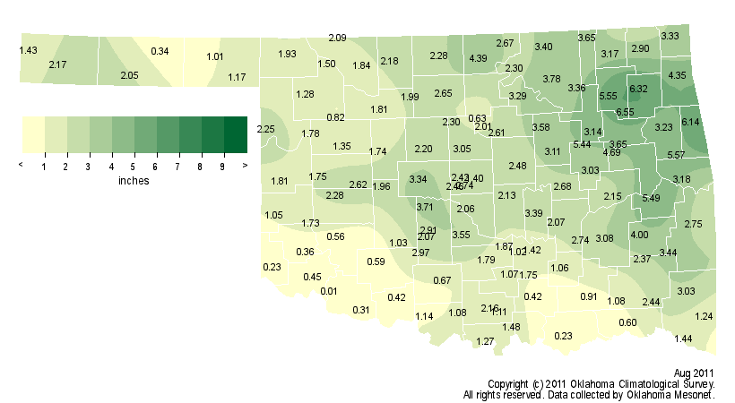
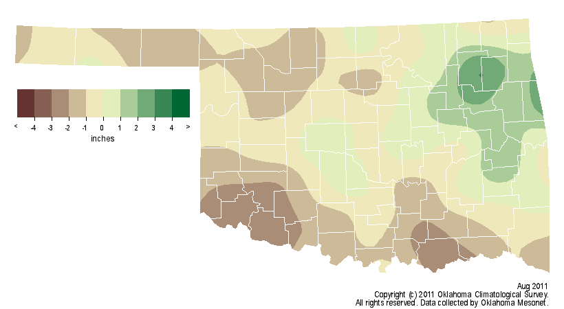
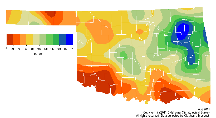
August saw relief for some but a continuation of desperate times for others.
The northeastern quarter of the state led the way with 4-6 inches of
drought-relieving rainfall. Much of the state saw at least 1-2 inches but high
temperatures and sunny skies made short work of that moisture. As for the
southwest and parts of south central Oklahoma, they were left high and dry
once again. The Oklahoma Mesonet site at Tipton saw a miserable one-hundredth
of an inch of rain during the month.
Gary McManus
Associate State Climatologist
Oklahoma Climatological Survey
(405) 325-2253
gmcmanus@mesonet.org
September 1 in Mesonet History
| Record | Value | Station | Year |
|---|---|---|---|
| Maximum Temperature | 110°F | WAUR | 2000 |
| Minimum Temperature | 49°F | GOOD | 2024 |
| Maximum Rainfall | 7.50 inches | BYAR | 2020 |
Mesonet records begin in 1994.
Search by Date
If you're a bit off, don't worry, because just like horseshoes, “almost” counts on the Ticker website!