Ticker for August 18, 2011
MESONET TICKER ... MESONET TICKER ... MESONET TICKER ... MESONET TICKER ...
August 18, 2011 August 18, 2011 August 18, 2011 August 18, 2011
Drought maintains its stronghold in western Oklahoma
The newest U.S. Drought Monitor released this morning keeps the D4 exceptional
drought in place across western Oklahoma, despite the 2-3 inches of rainfall in
a some areas. There was a 1-category improvement over in the northeast through
east central Oklahoma thanks to their more generous totals. The impacts we
highlighted last week in the southeast (streams drying up, endangered species
being threatened) led to a deterioration to D4 along the Red River.
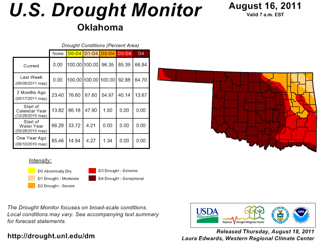
It was a close call for areas just west of Oklahoma City for improvement. In the
end, the return of triple-digit temperatures and the long-term deficits and
impacts won out. The wait is on to see if we will get reinforcing moisture that
will do more than wet the top layer of soil. So thee has been a slight increase
in the percentage of the state under the D4 designation (65% to 67%) but a
decrease in the amount of D3-D4 (93% to 85%). Drought relief is a process,
especially dryness of the magnitude faced by western Oklahoma.
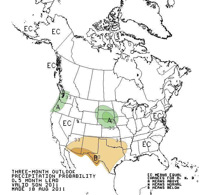
The look outwards sees some possible hope for some parts of the state, but
cautionary hope at that. As you can see, the northern one-third of the state and
down into east central Oklahoma is labeled in the "some improvement" category
in the latest U.S. Seasonal Drought Outlook.
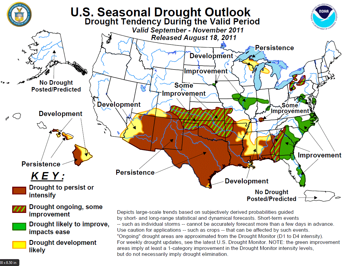
Should it come to fruition, good news indeed. But remember, drought improvement
is not drought elimination, necessarily. Here is the reasoning from the CPC
forecaster:
"The medium and extended range forecasts indicate enhanced chances for
below-median rainfall across the southern Plains states. The CPC
September and Fall outlooks maintain elevated chances of below-median
rainfall for most of the southern Great Plains and lower Southwest,
and also indicate elevated odds for above-normal temperatures. And
using the assumption of a La Ni?a developing later this fall, the
composite back to back La Ni?a anomalies indicate subnormal
precipitation for the Southwest and western and central Gulf Coasts,
with a slight hint of wetness in the southern High Plains. However,
any landfalling tropical systems in the western Gulf during the Fall
could provide relief to southeastern Texas. Based on these outlooks,
continued drought persistence is likely for the southern Plains
(if no landfalling tropical systems), with a chance for some slight
and spotty improvement in parts of the southern High Plains (low
confidence) and the northern edge of the drought (southern Kansas,
northern Oklahoma; moderate confidence)."
Here are those extended outlooks:
September
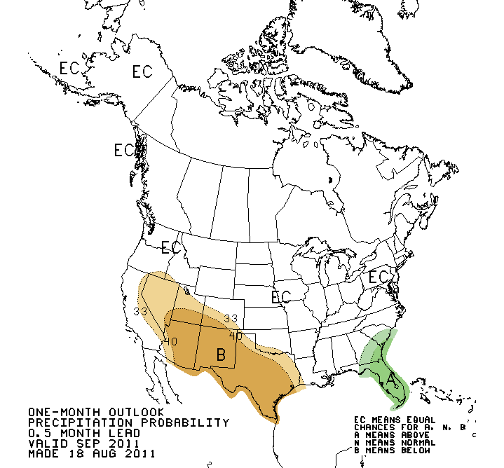
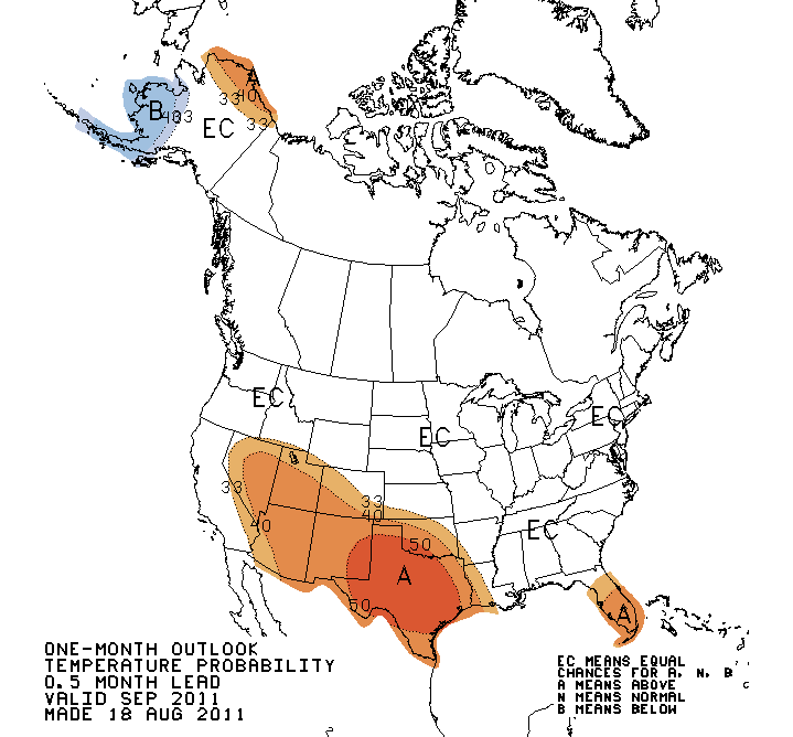
September-November
So the hope for improvements is a bit thin with low- to moderate-confidence
indicated by the forecaster, but it is hope! Here is the underlying reason
behind that hope for improvement. As mentioned above, the double-dip portion
of back-to-back La Ninas has had somewhat of a wet signal for northern parts
of the Southern Plains. The years indicated on the plot are the precipitation
anomalies that occurred during those year-two La Nina events.
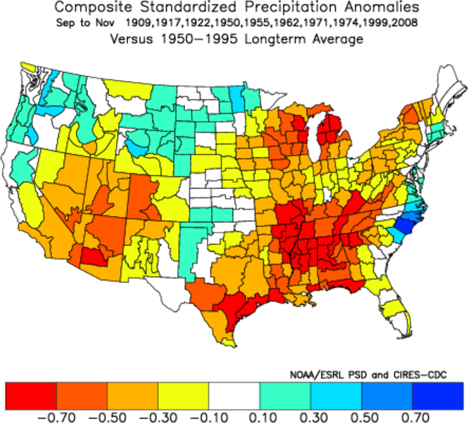
Same cautionary tale as always, each La Nina is different and they don't always
follow their scripts. These outlooks are simply what the forecasters see as the
evolution of the large-scale patterns across the U.S. for the next few months
given the most current information.
Gary McManus
Associate State Climatologist
Oklahoma Climatological Survey
(405) 325-2253
gmcmanus@mesonet.org
August 18 in Mesonet History
| Record | Value | Station | Year |
|---|---|---|---|
| Maximum Temperature | 112°F | GRA2 | 2023 |
| Minimum Temperature | 53°F | EVAX | 2016 |
| Maximum Rainfall | 9.00 inches | FTCB | 2007 |
Mesonet records begin in 1994.
Search by Date
If you're a bit off, don't worry, because just like horseshoes, “almost” counts on the Ticker website!