Ticker for August 1, 2011
MESONET TICKER ... MESONET TICKER ... MESONET TICKER ... MESONET TICKER ...
August 1, 2011 August 1, 2011 August 1, 2011 August 1, 2011
July Heat Becomes Historic
Fueled by exceptional drought and a seemingly impenetrable heat-dome, July roared
through Oklahoma?s legendary heat waves of the past to become the state?s hottest
calendar month on record. According to preliminary data from the Oklahoma Mesonet,
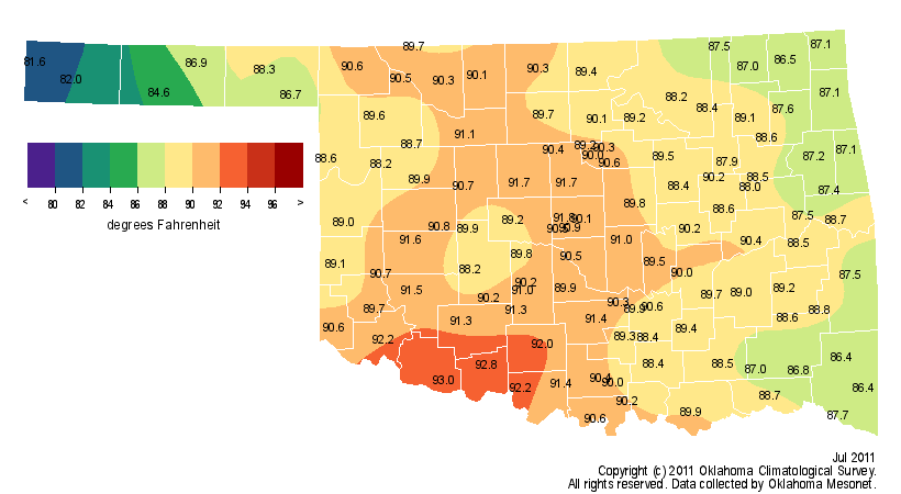
the July statewide average temperature finished 7.5 degrees above normal at 89.1
degrees, smashing the previous record of 88.1 degrees set back in July 1954.
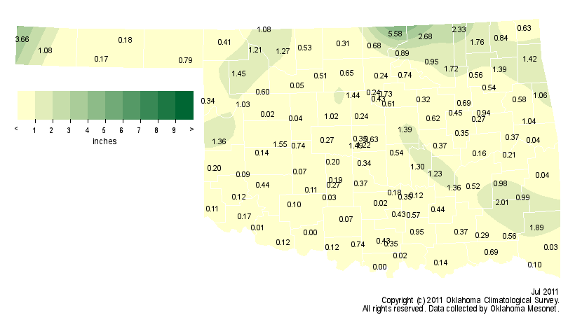
Statewide averages date back to 1895. The news was equally grim on the rainfall
side of the ledger. The statewide average rainfall total was 0.70 inches, more
than 2 inches below normal and the fourth driest July on record.
Combined, the 2011 June-July period was the hottest and driest on record
statewide, an ominous achievement with another month of summer yet to go.
Through seven months, 2011 ranked as the eighth warmest and second driest on
record.
Oklahoma City?s average temperature of 89.2 degrees topped the previous record
of 88.7 degrees from August 1936 to become its warmest month since those
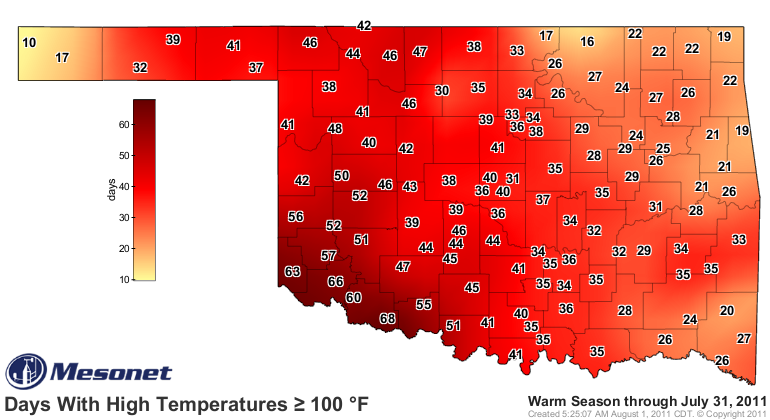
records began in 1890. Oklahoma City experienced 27 days in July with a high
temperature of at least 100 degrees, once again the most for any month in its
history. Oklahoma City?s average high temperature of 102.5 degrees beat July
1980?s previous mark of 102.4 degrees to set another milestone. Similar records
were matched at many locations throughout drought-ravaged western Oklahoma.
Grandfield was the warmest spot in the state with an average July temperature
of 93 degrees and an average high of 107 degrees. Grandfield continued to lead
the state with 68 days at or above 100 degrees in 2011. The record stands at 86
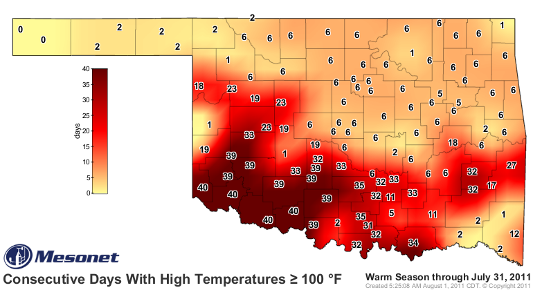
days, set by Hollis in 1956. That site and three others have seen triple-digit
highs for 40 consecutive days through July 31. Kenton?s July average of 81.6
degrees marked it as the coolest spot in the state. The highest temperature of
the month, 114 degrees, was recorded at Alva and Freedom on July 9.
Of the 120 Oklahoma Mesonet stations, 93 recorded less than an inch of rainfall
for the month. Walters and Burneyville recorded no precipitation for the entire
month. Newkirk and Kenton led the way with 5.58 inches and 3.66 inches,
respectively. Only five stations recorded more than 2 inches of rainfall.
Southwestern Oklahoma received less than a quarter-inch of rainfall, on average.
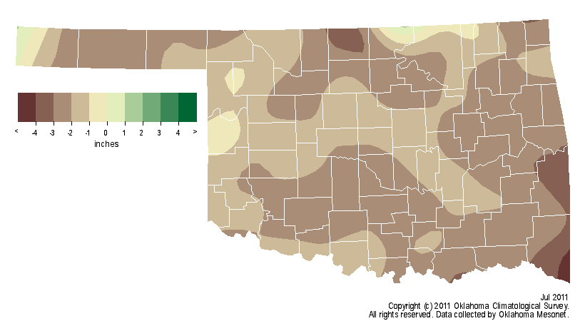
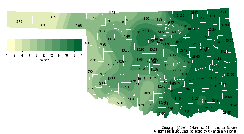
An average of 16.41 inches of precipitation has fallen across the state since
October 1, 2010, nearly 14 inches below normal and the driest such period on
record. Boise City received a scant 3.8 inches of rainfall over that time while
Grandfield measured 5.6 inches.

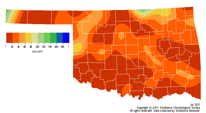
The latest U.S. Drought Monitor map released on July 28 indicates more than
half of Oklahoma is experiencing exceptional drought, the worst designation
possible.
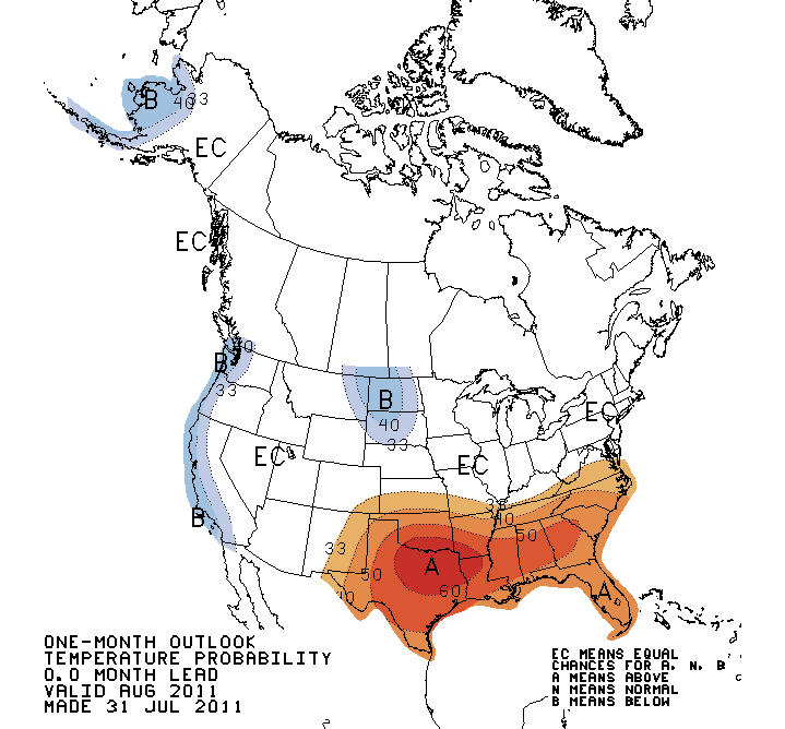
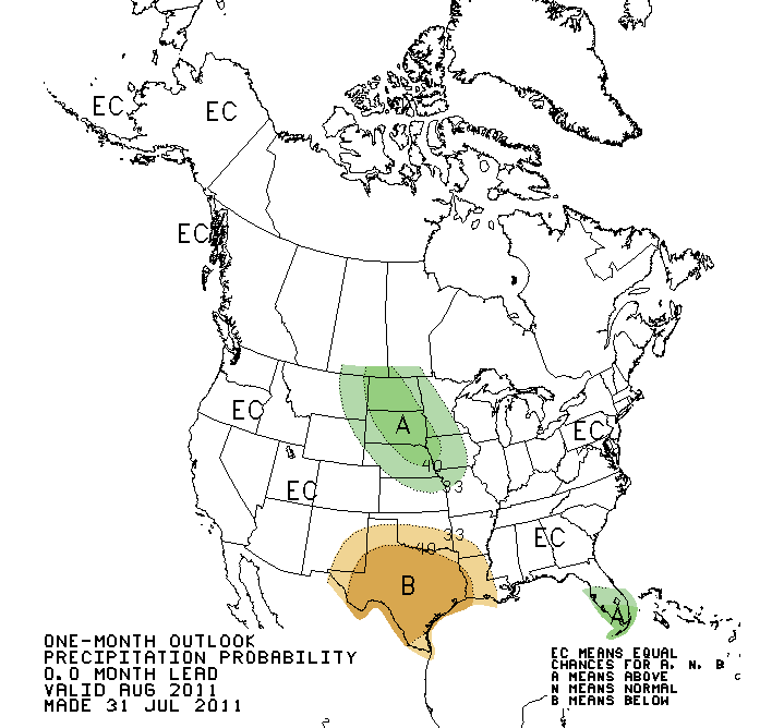
Unfortunately, there is little relief in sight as the heat and drought continue
to feed off one another. The latest outlooks for August from the National
Weather Service?s Climate Prediction Center indicate increased chances of above
normal temperatures and below normal precipitation. Their seasonal drought
outlook calls for the persistence or intensification of drought conditions
across Oklahoma and Texas through October.
Gary McManus
Associate State Climatologist
Oklahoma Climatological Survey
(405) 325-2253
gmcmanus@mesonet.org
August 1 in Mesonet History
| Record | Value | Station | Year |
|---|---|---|---|
| Maximum Temperature | 115°F | KIN2 | 2012 |
| Minimum Temperature | 53°F | KENT | 2018 |
| Maximum Rainfall | 5.04 inches | NOWA | 1995 |
Mesonet records begin in 1994.
Search by Date
If you're a bit off, don't worry, because just like horseshoes, “almost” counts on the Ticker website!