Ticker for May 5, 2011
MESONET TICKER ... MESONET TICKER ... MESONET TICKER ... MESONET TICKER ...
May 5, 2011 May 5, 2011 May 5, 2011 May 5, 2011
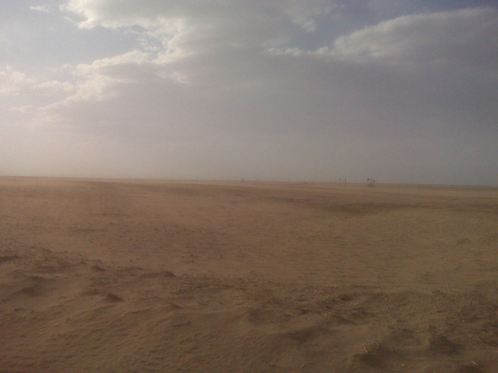
I won't lie to ya ... I ordered the hit on the drought in eastern Oklahoma. And
no, I won't show the photographs. I will show you a rather gruesome picture
from the western Oklahoma Panhandle that I received from a Ticker-ite. It shows
just how bad things have gotten in that part of Oklahoma and also served as the
impetus for the push for D4 drought out there. Trust me, a picture is indeed
worth a thousand words. Our latest press release on the drought follows.
********************************
Drought Intensifies in Western Oklahoma
Fresh off the heels of yet another dry month in western Oklahoma, the latest map
from the U.S. Drought Monitor indicates an intensification of the ongoing drought
in that part of the state. Exceptional drought, the Drought Monitor?s most severe
classification, now covers the extreme southwestern corner of the state and the
western Oklahoma Panhandle. The Drought Monitor?s intensity scale ranges from
?abnormally dry? to ?exceptional?. Most of the remainder of western Oklahoma is
covered by extreme to severe drought. Central Oklahoma has a mixture of extreme
to moderate drought while the eastern one-third of the state is now free of
drought thanks to recent heavy rains.

According to the Drought Monitor, the impacts of exceptional drought include
widespread crop and pasture losses and shortages of water in reservoirs,
streams and wells. Much of southwestern Oklahoma and the western Panhandle
received less than 20 percent of normal rainfall during April. The Oklahoma
Mesonet site at Hollis recorded less than a tenth of an inch for the month.
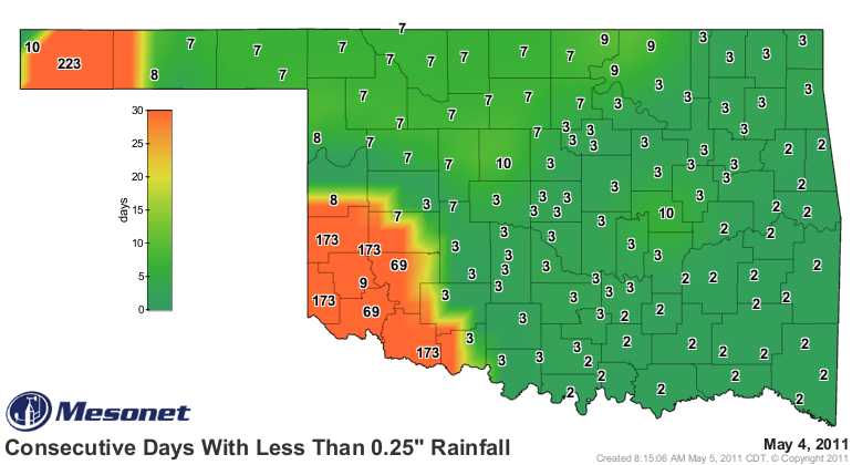
Boise City in the far western Panhandle eclipsed a dubious record by stretching
its streak of consecutive days without at least a quarter-inch of rain on any
single day to 223. The record for that area is 218 days from September 1988 to
April 1989. In contrast, the ironically named Westville along the Arkansas
border totaled nearly 15 inches of rain as the surrounding areas dealt with
flood concerns.
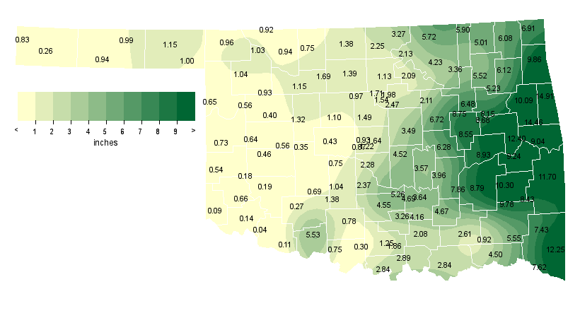

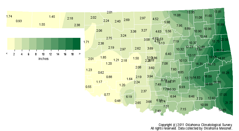
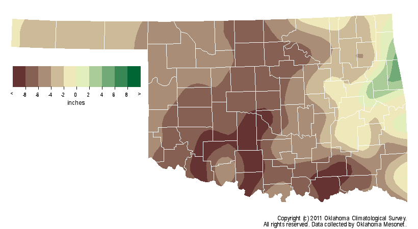
The dry conditions during April continue a string of dry months and mounting
rainfall deficits in the western half of the state. From December 2010 through
April 2011, southwestern and west central Oklahoma received 1.67 inches and
1.74 inches of rainfall, respectively. That ranks as the driest such period on
record for those areas dating back to 1895. Central Oklahoma fared little
better with 4.63 inches, their third driest such period on record.
Widespread damage and destruction of the winter wheat crop has already occurred
in the western half of the state. Wheat in southwestern Oklahoma and the
western Panhandle has been particularly hard hit. A recent unofficial estimate
of this year?s wheat harvest indicates it could be nearly half of last year?s
126 million bushels. Additionally, the livestock industry has been hurt by the
loss of pasture, hay, and stock ponds. The wildfire season continues to be
extended in western Oklahoma thanks to a delayed green-up as vegetation
continues to die or remains dormant due to the lack of moisture.
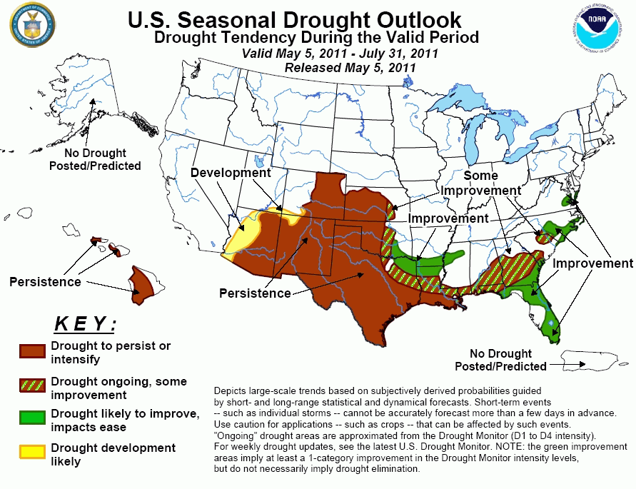
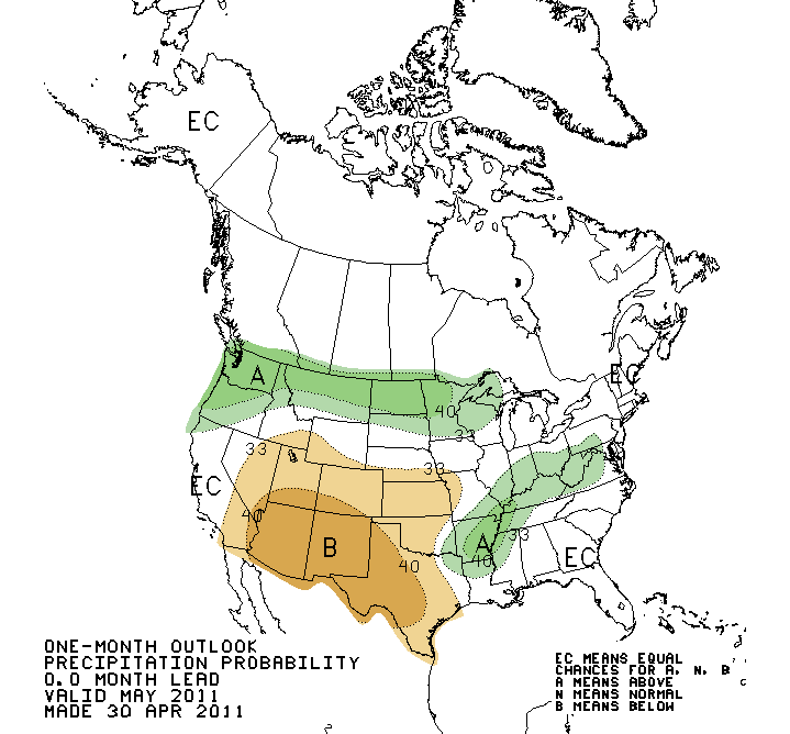
Outlooks from the National Weather Service?s Climate Prediction Center for
both the short- and long-term periods are not promising for western Oklahoma.
Increased chances of below normal rainfall are indicated through May for much
of the state, especially in the southwest. The latest U.S. Seasonal Drought
Outlook indicates the persistence or intensification of drought for the western
half of Oklahoma through July. Improvement is possible in central and
southeastern Oklahoma.
Gary McManus
Associate State Climatologist
Oklahoma Climatological Survey
(405) 325-2253
gmcmanus@mesonet.org
May 5 in Mesonet History
| Record | Value | Station | Year |
|---|---|---|---|
| Maximum Temperature | 106°F | ALTU | 2012 |
| Minimum Temperature | 29°F | KENT | 2013 |
| Maximum Rainfall | 4.13 inches | WEB3 | 2022 |
Mesonet records begin in 1994.
Search by Date
If you're a bit off, don't worry, because just like horseshoes, “almost” counts on the Ticker website!