Ticker for April 28, 2011
MESONET TICKER ... MESONET TICKER ... MESONET TICKER ... MESONET TICKER ...
April 28, 2011 April 28, 2011 April 28, 2011 April 28, 2011
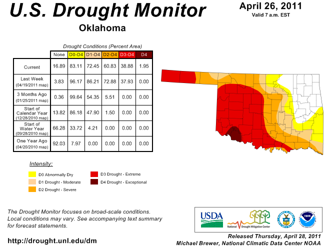
D4 "Exceptional" Drought Hits Oklahoma
Just a quick note, with most attention focused (and rightfully so) on the
tragic tornado story to our east. We asked for and received a D4 or "exceptional"
drought designation for parts of southwestern Oklahoma on the latest U.S Drought
Monitor map. D4 is the worst of the drought intensity levels depicted by the
Drought Monitor. The D4 area in Oklahoma is centered on Tillman County but also
encompasses parts of the surrounding counties
We asked for that designation to properly portray the devastation of the winter
wheat crop caused by the drought conditions. The Oklahoma Mesonet site at
Grandfield, for instance, has had less than an inch of rain in the last 180 days.
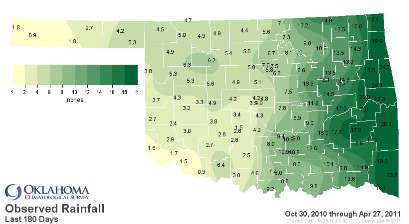
As depicted in the map, most of western Oklahoma is suffering a similar (if not
quite as dire) dry fate. The western Oklahoma Panhandle is equally as dry over
that time period. That area and southwestern Oklahoma share a similar story,
however, and that is one of agricultural disaster. Widespread loss of wheat,
withered and still-dormant pastures and bone-dry stock ponds are all common
themes up and down the western half of the state. The D3 or "extreme" drought
designation was brought farther to the north and west as well.
You will also notice that the rains of the last week allowed for a reduction or
outright removal of the drought tag in eastern Oklahoma.
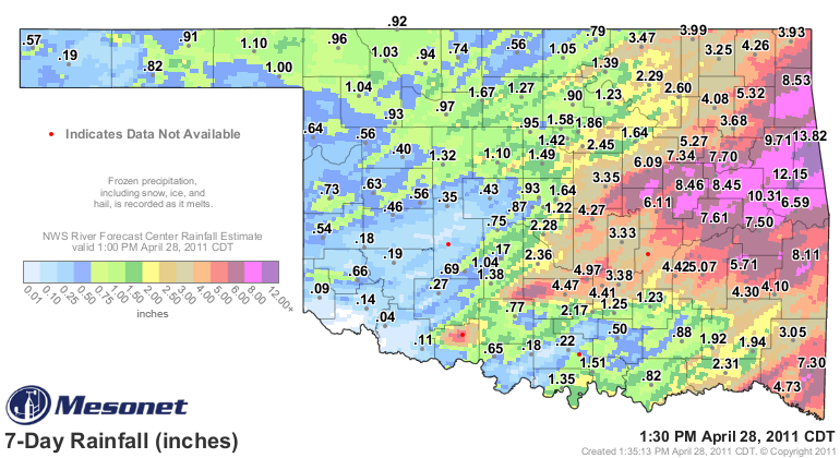
Widespread amounts of 6-12 inches tend to be drought-killers. However, the
almost-nothing to 1-inch amounts in western Oklahoma are certainly welcome, but
far from drought-busters.
They did allow for resets in most of the state for the following two maps.
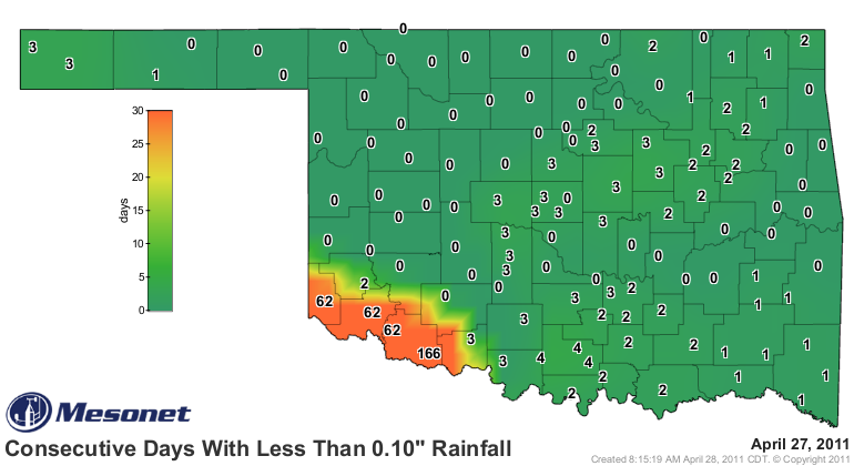
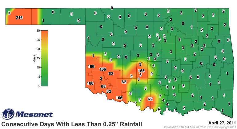
The 216-day mark at Boise City is quite impressive. The record for that area is
218 days. If they escape Saturday with less than a quarter-inch of rain, they
break their record for longest streak without at least a quarter-inch of rain
in a single day. Let's hope that streak ends on Saturday.The dry conditions in
southwestern Oklahoma are also very evident. I'm not sure who Chickasha angered
to get that 163-day mark, but it's not a nice way to stand apart from your
neighbors.
Gary McManus
Associate State Climatologist
Oklahoma Climatological Survey
(405) 325-2253
gmcmanus@mesonet.org
April 28 in Mesonet History
| Record | Value | Station | Year |
|---|---|---|---|
| Maximum Temperature | 98°F | ALTU | 2020 |
| Minimum Temperature | 27°F | BOIS | 2008 |
| Maximum Rainfall | 6.80 inches | MADI | 2006 |
Mesonet records begin in 1994.
Search by Date
If you're a bit off, don't worry, because just like horseshoes, “almost” counts on the Ticker website!