Ticker for October 21, 2010
MESONET TICKER ... MESONET TICKER ... MESONET TICKER ... MESONET TICKER ...
October 21, 2010 October 21, 2010 October 21, 2010 October 21, 2010
Okay, it gets scary AFTER Halloween
I don't need to walk over a bed of hot coals to prove my mettle, I walked barefoot
across my grass yesterday. Even as we all sit and wait for the deluge of
much-needed rainfall over the next couple of days, the folks at the NWS' Climate
Prediction Center (CPC) have thrown a warm bucket of dry over the state.
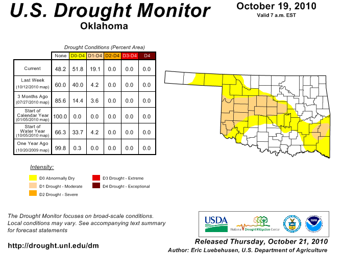
First, the starting conditions - I detailed how dry we had become, especially in
the western half and the southeastern corner of the state. Today's newest release
from the U.S. Drought Monitor, at the urging of OCS, reflects those worsening
conditions with a spread of moderate drought across a broad area of west central
through central Oklahoma.
Now of course we're all hoping the coming rains relieves some of that dryness, but
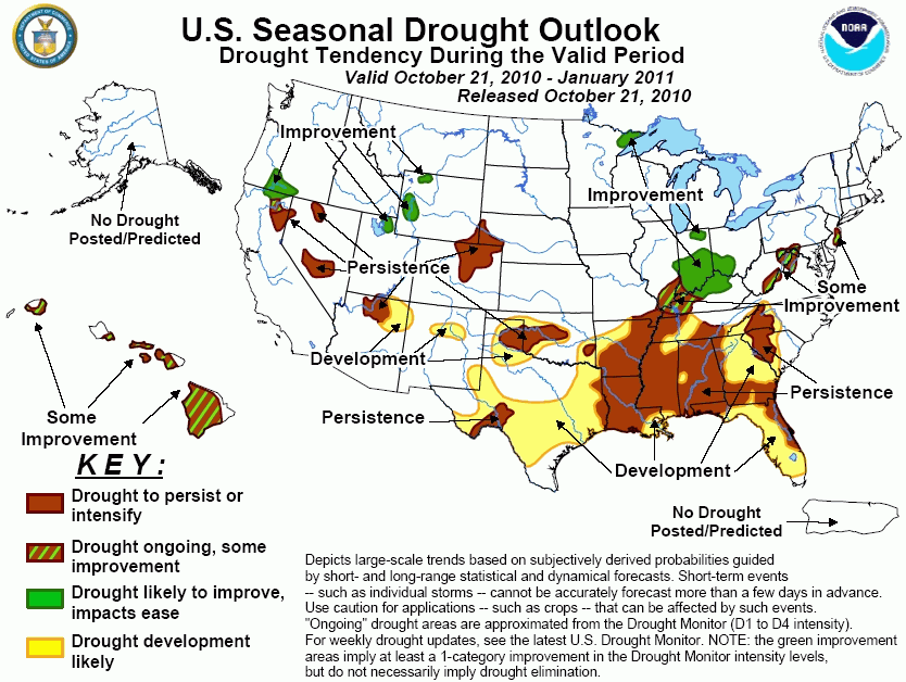
the CPC forecasters paint a gloomier picture, even after taking the possible
moisture into account. Their latest drought outlook indicates droughty conditions
to not only persist in Oklahoma, but also to spread a bit more through January:
Their reasoning:
"Soil moisture that was plentiful across much of the southern Great Plains
following the early September passage of Tropical Storm Hermine has
dwindled as much drier weather has occurred the past 45 days. An exception
to this has been extreme southern Texas where ample mid- to late September
rains have maintained wetness. With the exception of heavy rains during
the next 5-days (from HPC) in northern Texas and Oklahoma, all forecasts
from the short to medium range through the seasonal outlook indicate
enhanced chances of below-median precipitation and above-normal
temperatures. And with the likelihood of little or no "bonus" tropical
cyclone rains (such as from Hermine) in the western Gulf Coast due to
decreased tropical cyclone formation and southward-displaced mid-latitude
troughs that tend to recurve any tropical cyclones eastward away from the
region, drought persistence is maintained in Oklahoma and northern and
southwestern Texas. In addition, development was extended across most of
south-central Texas, northern Texas and Oklahoma, and parts of eastern New
Mexico where La Nina conditions are strongly associated with decreased
precipitation and increased temperatures. Forecast confidence for the
southern Plains is moderate to high."
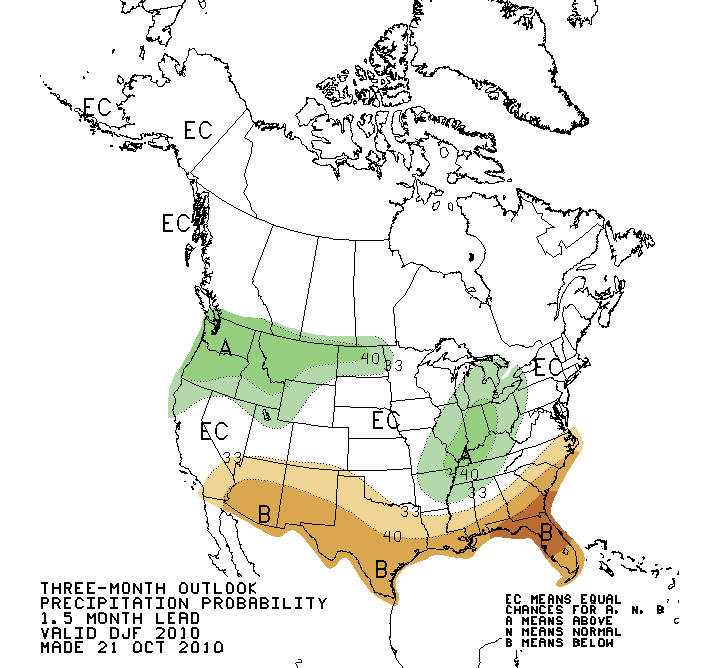
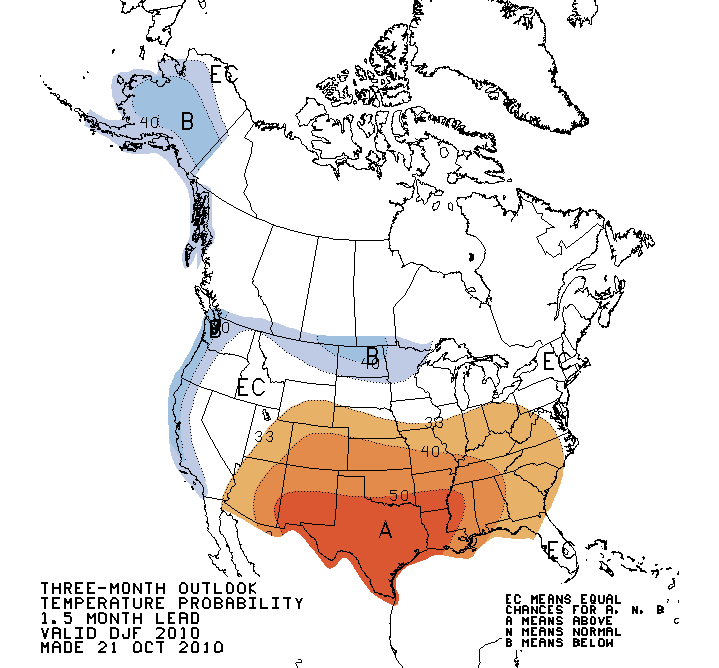
Since they mention the seasonal outlook, let's take a look at those as well. Here
are the CPC's temperature and precipitation outlooks for the November-January
period, and they just stink of La Nina.
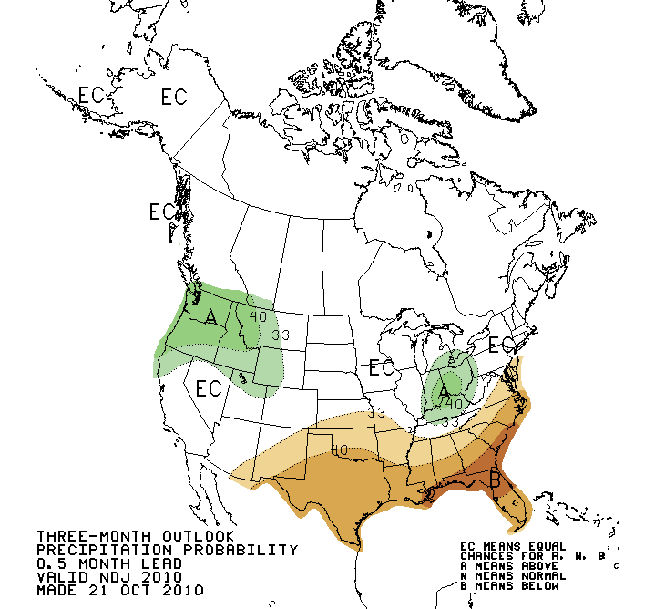
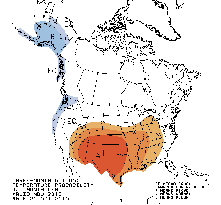
As you can see, the bulk of the warm signal covers the state as well as much
of Texas, New Mexico, Kansas and Colorado. Oklahoma is also contained within
the "greater chance of drier conditions" signal, but the worst of that signal
is clearly over the southeastern U.S.
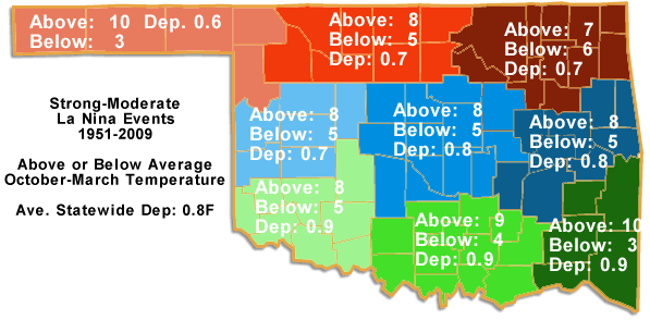
OCS has taken a look at the 13 strong-moderate La Nina events since 1951 and
examined the effects on Oklahoma's cool-season (October-March) temperature
and precipitation. Our results indicate the tendency for a warmer and drier
cool season over much of the state during strong-moderate La Nina events (keep
in mind this La Nina is still being mentioned as possibly the strongest since
1951).

Okay, what's it all mean? Let me give you a climatologist's interpretation.
1. Sometimes these seasonal outlooks are a crap shoot. However, during El Nino
or La Nina events, the confidence in them increases significantly. In the CPC's
own words: "Forecast confidence for the southern Plains is moderate to high."
2. Does this mean that it will be 75 degrees on Christmas, and no chances for a
white Christmas? No, these are looking over the longer-term. They say nothing
about singular events. So when January 31 rolls around and we take a look back
at the November-January period, the statistics could show it was warmer and
drier. Even in that scenario, however, really cold and wet weather could show
up form time to time. Besides, our chances for a white Christmas are extremely
low every year. Bah humbug!
3. Yayyyyy, no ice storms or blizzards! Again, the outlooks say nothing about
singular events. In fact, significant ice storms struck the state during the La
Nina winters of 2000-01 and 2007-08 (to the tune of 810,000 electric utility
customers without power and damges of more than $1 billion).
4. Winter is dry anyway. The months ahead are considered a recharge period for
our moisture since most plants are dormant and we aren't using as much water
ourselves (watering lawns, filling pools, washing cars, etc.). But impacts
of a warmer and drier November-January coupled with dry conditions already in
place can include increased wildfire risk and damage to the state's wheat crop
(and therefore reducing grazing for cattle producers). That's why it would be
nice to get a good dose of rain this weekend.
5. As a final caution in dealing with these outlooks, it's important to remember
that La Nina is not the only climate factor that can affect our weather. There
are other factors much more difficult to predict on short timescales that
could blow all this up.
Finally, if we skip a month ahead and look at the December-February outlooks,
the dry signal diminishes a bit as the impacts from La Nina ease up farther into
the season (although the warm outlook is still fairly strong).
Gary McManus
Associate State Climatologist
Oklahoma Climatological Survey
(405) 325-2253
gmcmanus@mesonet.org
October 21 in Mesonet History
| Record | Value | Station | Year |
|---|---|---|---|
| Maximum Temperature | 98°F | MANG | 2012 |
| Minimum Temperature | 23°F | KENT | 2019 |
| Maximum Rainfall | 5.60 inches | ANTL | 1996 |
Mesonet records begin in 1994.
Search by Date
If you're a bit off, don't worry, because just like horseshoes, “almost” counts on the Ticker website!