Ticker for August 1, 2010
MESONET TICKER ... MESONET TICKER ... MESONET TICKER ... MESONET TICKER ...
August 1, 2010 August 1, 2010 August 1, 2010 August 1, 2010
A Tale of Two Julys and BIG TORNADO NEWS (not news about big tornadoes)!
"It was the best of..."
Never mind, I think I did that one already. But July certainly fell under two
regimes. The first half of July was all about rain before the month transitioned
into more of a classic summer pattern. After water fell by the lake-full early on,
the sun worked its magic evaporating all that moisture from the soil and we had
a miserable middle of July with heat indices in the 110s. Now we have moved on
to life under an upper-level ridge with air temperatures hitting triple digits
over much of the state.
Is this heat unprecedented in Oklahoma? Of course not...it's summer. In fact,
summer thus far has resembled 2007's warm months when a wet and cool June and
July gave way to a very hot August. During that year, only three 100s had been
reported by the Mesonet. By the end of August, however, every station had
reported a triple-digit temperature. Let's hope the comparisons end there. The
last thing we need is another tropical storm Erin intensifying over the state
and giving us a foot of rainfall. I believe we've had our share of flash flooding
for awhile. The Mesonet has had 59 stations record at least 100 degrees so far
this summer. That count was 38 of Friday, so expect that count to continue
expanding.
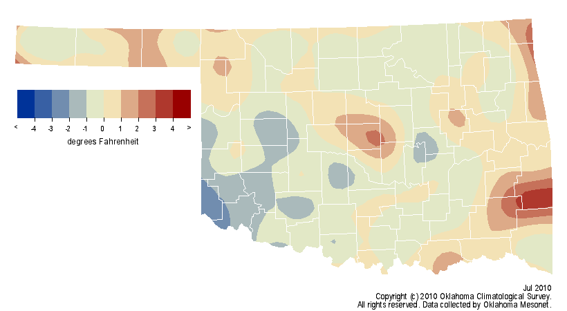
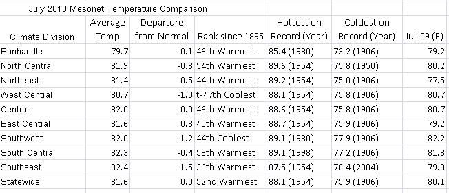
So what about July? Well, the result of the transition from wet/mild to dry/hot
should not be shocking ... the month finished dead normal with a statewide
average temperature of 81.6 degrees, the 52nd-warmest July since 1895 for
Oklahoma. There were pockets of cool and warm, of course, influenced mostly by
rainfall. Here are looks at the departure from average temperatures across the
state and the rankings:
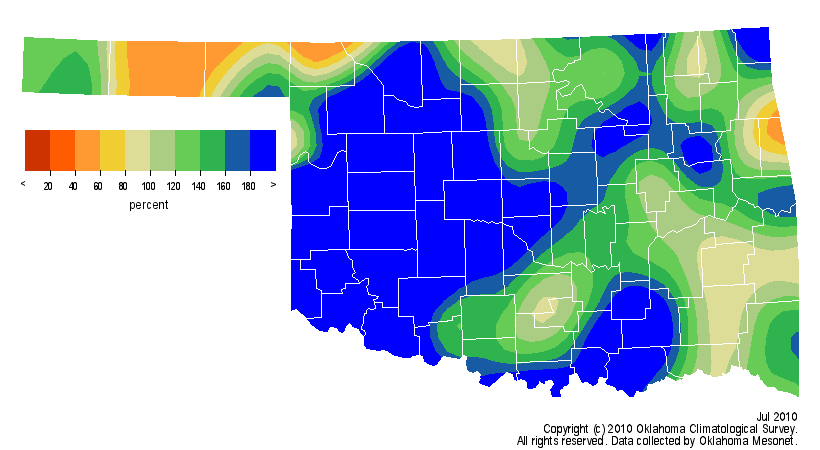
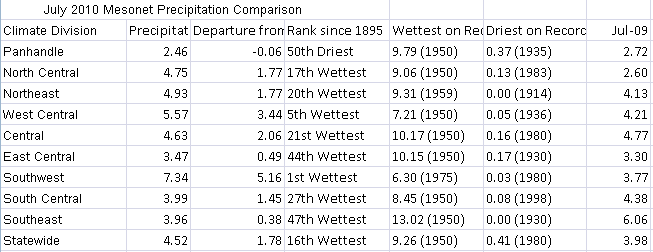
The rainfall early on boosted us to the 16th-wettest July since 1895 with a
statewide average of 4.52 inches, a surplus of 1.78 inches. Most of that lofty
ranking is due to the wettest July on record for the southwest and the fifth-
wettest for the west central climate division. Southwestern Oklahoma's average
during July was 7.34 inches, 5.16 inches above normal. Take a look at total
rainfall, percent of normal rainfall, departure from normal rainfall, and the
rainfall rankings (respectively):
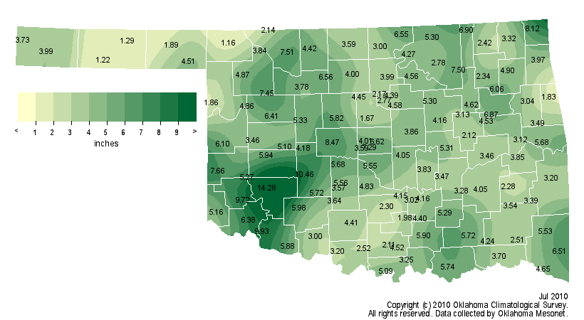
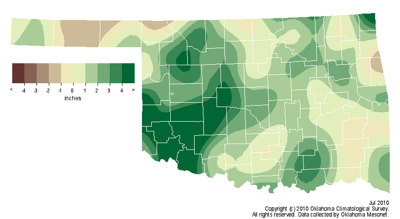
The Medicine Park Mesonet site recorded a whopping 14.28 inches of rain during
July while Buffalo, the greatest place to live in the state (yeah, I said it),
brought up the rear with 1.16 inches.
********************************
May 2010 Tornado Count Ties 1999 Record
The latest word from Doug Speheger, NWS Norman forecaster and Grand Poobah of
Oklahoma tornado records, is that the tornado count for May 2010 is now
up to 90, which ties it with May 1999 as the most tornadoes during a single
month since accurate records began in 1950. That total exceeds the annual
average of 53.1, let alone the May average of 20.1, and the total may continue
to go up as Doug pores through the reports. The annual count is up to 93 which
would place it in fifth place:
Year Total
1999 145
1957 107
1982 101
1960 98
2010 93
1983 92
Let's hope we stay at #5 or FEMA may move their national headquarters here.
Gary McManus
Associate State Climatologist
Oklahoma Climatological Survey
(405) 325-2253
gmcmanus@mesonet.org
August 1 in Mesonet History
| Record | Value | Station | Year |
|---|---|---|---|
| Maximum Temperature | 115°F | KIN2 | 2012 |
| Minimum Temperature | 53°F | KENT | 2018 |
| Maximum Rainfall | 5.04 inches | NOWA | 1995 |
Mesonet records begin in 1994.
Search by Date
If you're a bit off, don't worry, because just like horseshoes, “almost” counts on the Ticker website!