Ticker for October 12, 2009
MESONET TICKER ... MESONET TICKER ... MESONET TICKER ... MESONET TICKER ...
October 12, 2009   October 12, 2009   October 12, 2009   October 12, 2009


Happy Holidays!

That Thanksgiving feast sure was good. Now I have to get all my shopping finished
before ... well, wait a minute. I didn't REALLY just have my turkey and pie, but
the weather has sure made a jump forward a month or two with highs in the 40s
and 50s for the most part the last few days. Woodward's high on Saturday was a
chilly 39 degrees, a temperature more appropriate for late-December than
mid-October.

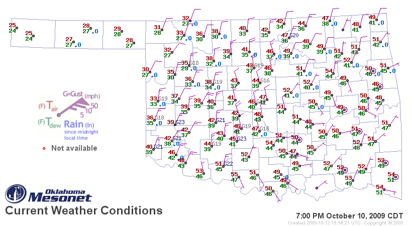
In fact, the Panhandle gave us our first taste of frozen anemometers this season
with a combination of freezing temperatures and drizzle this weekend to form
... freezing drizzle! Wow, I get paid for this job? But yes, the accumulations
were enough to bring our Mesonet anemometers in the Panhandle to a standstill,
as you can see from this sample Mesonet map on Saturday night:


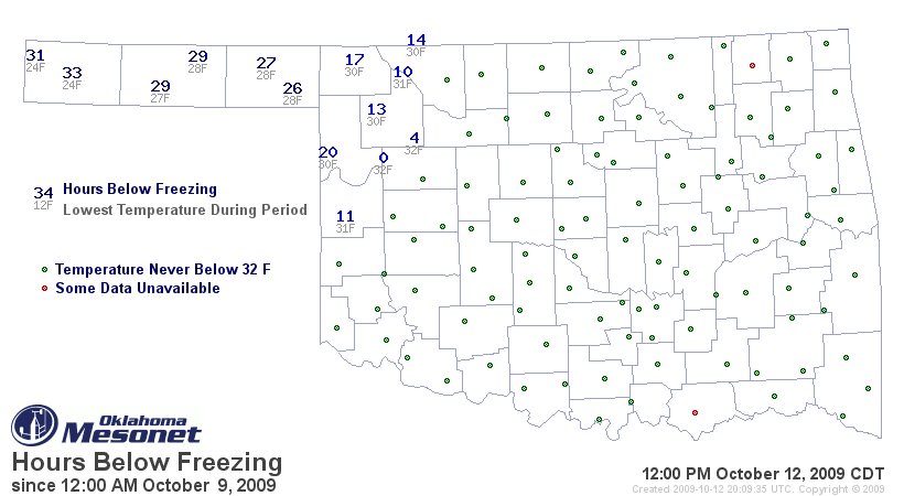
It did get significantly cold in the Panhandle this weekend, so they have gotten
their hard freeze out of the way a bit early. The western Panhandle dropped
down to as low as 24 degrees, and as many as 33 hours spent below 32 degrees.


With more rains forecast for the next couple of days, October has lived up to
it's notoriety as the state's fourth-wettest month. This October already ranks
as the 36th wettest since 1895 with a statewide average of 3.55 inches, so any
additional rainfall will zoom it upwards in the rankings. Normal for the entire
month is 3.38 inches. It has a long way to go to top October's record of 11.32
inches set in 1941, not only the final nail in the Dust Bowl drought's coffin,
but also the wettest month on record for Oklahoma.

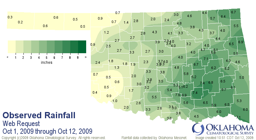
Climate Division 9, the southeastern corner, has had its wettest October 1-12
on record with an average of 6.11 inches, 4.15 inches (or 312%) above normal.
For a look at our precipitation thus far this month, take a look here:


Heavy rains forecast for the eastern portions of the state will undoubtedly
create more flooding problems, so keep tuned to your local NWS office for more
information.

BRRR!!!

Gary McManus
Associate State Climatologist
Oklahoma Climatological Survey
(405) 325-2253
October 12 in Mesonet History
| Record | Value | Station | Year |
|---|---|---|---|
| Maximum Temperature | 99°F | MANG | 2024 |
| Minimum Temperature | 23°F | EVAX | 2019 |
| Maximum Rainfall | 2.92″ | MIAM | 2016 |
Mesonet records begin in 1994.
Search by Date
If you're a bit off, don't worry, because just like horseshoes, “almost” counts on the Ticker website!