Ticker for June 25, 2008
MESONET TICKER ... MESONET TICKER ... MESONET TICKER ... MESONET TICKER ...
June 25, 2008      June 25, 2008      June 25, 2008      June 25, 2008


Ticker Request Line: Hail-O, may we hailp you?

We continue with our recent rash of really relevant requests:

"Everything you ever wanted to know about hail but were
afraid to ask."

Wow, that's a broad topic, and we're gonna touch on a lot of things
briefly (it's the USAToday-ification of the Ticker, only with a few
million fewer subscribers).

Hail Note 1: Distinction from Sleet

Hail and sleet are similar in some ways: for both, talking about
frozen particles falling from the sky. Both are the consequence
of the freezing of liquid water. Both are cold. So, what's
the difference? Sleet is a cold weather precipitation type that
forms when cold raindrops fall through a layer of very cold air
near the surface and freeze before contact. Hail forms in
convective situations (thundershowers, thunderstorms that have
a significant updraft). Sleet particles freeze on the way down,
during the last portion of their descent. Hail typically forms
in an updraft (air moving upward), farther above the surface,
then falls to the ground later.


Hail Note 2: Where does hail come from?

Within a storm, precipitation particles are formed when moist
air rises, condenses and cools. The details are complicated, but
that's the basic process. Sometimes, the updraft is strong enough
to suspend precipitation particles very high above the ground,
where temperatures are below freezing:


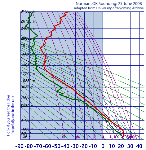
This sounding shows temps (red line) as you go up in the
atmosphere. Notice that, even today, the freezing level [blue
shade] is only 12-ish thousand feet off the ground. Storms
can grow to four or five times that height.

Anyway, if particles are held (by updraft winds) in this
sub-freezing zone long enough, they will freeze. If they
continue to be held aloft above the freezing level, more water
that is transported up from below will freeze onto the growing
stone (intermittent "layers" of frozen water can give a
hailstone its onion-like layered appearance).

Eventually, the updraft weakens, or the stone grows too large
to be supported by it (or a combo of both). When that happens,
gravity wins, and hailstones fall from the sky. Tiny stones
will melt, bigger ones won't.

As you've probably guessed by now, the *size* of the hailstone
is directly related to the strength of the updraft. Simply put:
the stronger the updraft, the bigger stone it can support.


Hail Note 3: What is "severe" hail?

The National Weather Service considers a thunderstorm "severe"
if it meets any one of three requirements:
1. Winds exceeding 50 knots (about 58 mph)
2. It produces a tornado (duh)
3. It produces hail of 3/4 inch or larger

In 2006, an NWS pilot project raised the hail threshold to one-inch
for the entire state of Kansas and some neighboring counties in
Colorado, Nebraska and Missouri.


Hail Note 4: How do they get hail size from radar?

A series of algorithms has been developed to help estimate hail-size.
These are simply models that estimate hail size. Repeat after us:

"ALL MODELS ARE WRONG. SOME MODELS ARE USEFUL."

These algorithms are improving, and so are the radars themselves,
but radar-indicated hail size is still not considered definitive
in the operational environment.


Hail Note 5: If radar only estimates hail size, where do official
reports come from?

Official hail reports come from the most complex, adaptable,
mobile, proven, reliable, definitive weather observing platform
in the history of the planet. This instrument is called "homo
sapiens".


Hail Note 6: What is the biggest hailstone ever observed in the U.S.?

Seven inches across, 18.75 inches around. Aurora, Nebraska:
http://www.noaanews.noaa.gov/stories/s2008.htm


Hail Note 7: What is the biggest hailstone that ever fell in Oklahoma?

We're limited only to those stones that have been observed and
reported. In April 1935, a hailstorm dropped stones up to 14 inch
circumference in Kay County.


Hail Note 8: Disappearing Hail Reports

The tornado-chasing-spotting-observing craze of recent years has
taken its toll on good hail reporting. Despite the fact that hail
impacts dozens of square miles at a time, and tornadoes only a
tiny fraction of that, many chasers are only apt to report
tornadoes.

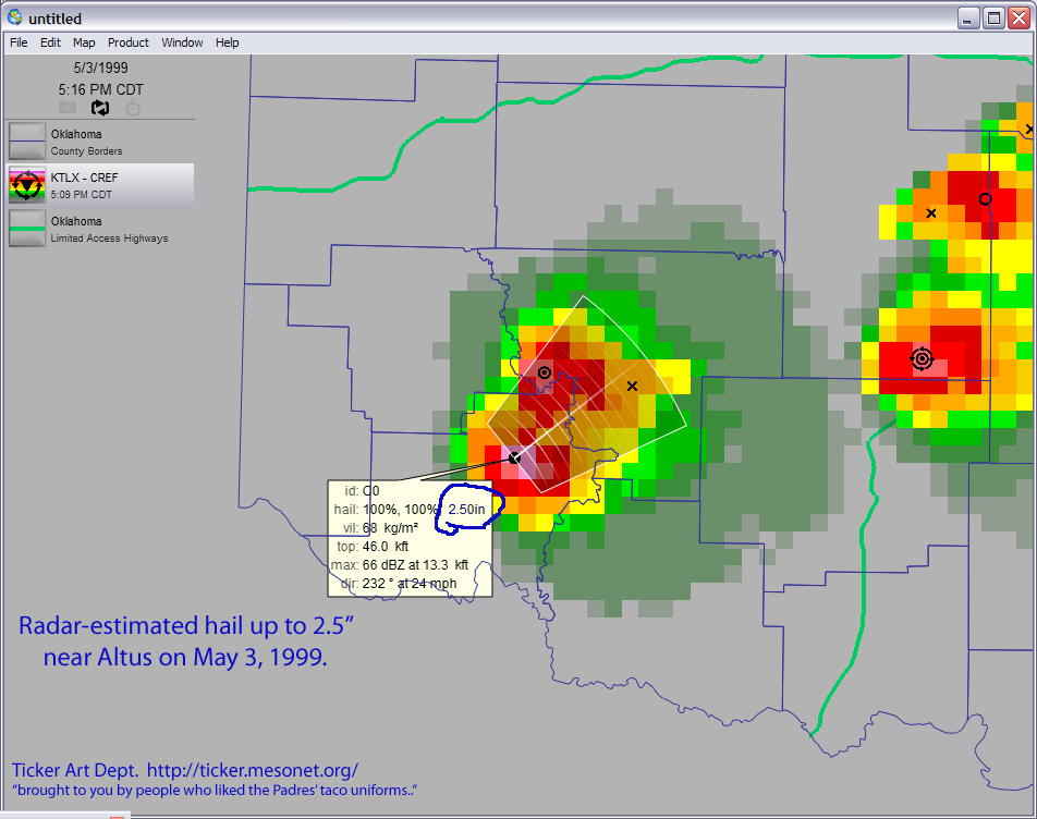
May 3, 1999 is marked by a very low total of hail reports, despite
the fact that HUGE hail was suggested by radar, and confirmed in
a few locations. The lack of hail reports doesn't mean it didn't
happen; it's just that all eyes were tuned for tornadoes.
June 25 in Mesonet History
| Record | Value | Station | Year |
|---|---|---|---|
| Maximum Temperature | 111°F | ERIC | 2011 |
| Minimum Temperature | 50°F | KENT | 2018 |
| Maximum Rainfall | 4.11 inches | WAUR | 1999 |
Mesonet records begin in 1994.
Search by Date
If you're a bit off, don't worry, because just like horseshoes, “almost” counts on the Ticker website!