Ticker for May 22, 2008
MESONET TICKER ... MESONET TICKER ... MESONET TICKER ... MESONET TICKER ...
May 22, 2008 May 22, 2008 May 22, 2008 May 22, 2008
Western Panhandle: Severe Winds, and ...
Last night at about 10 o'clock, the Kenton Mesonet site observed
severe winds (59 mph) as some much-needed convection passed over
the station:
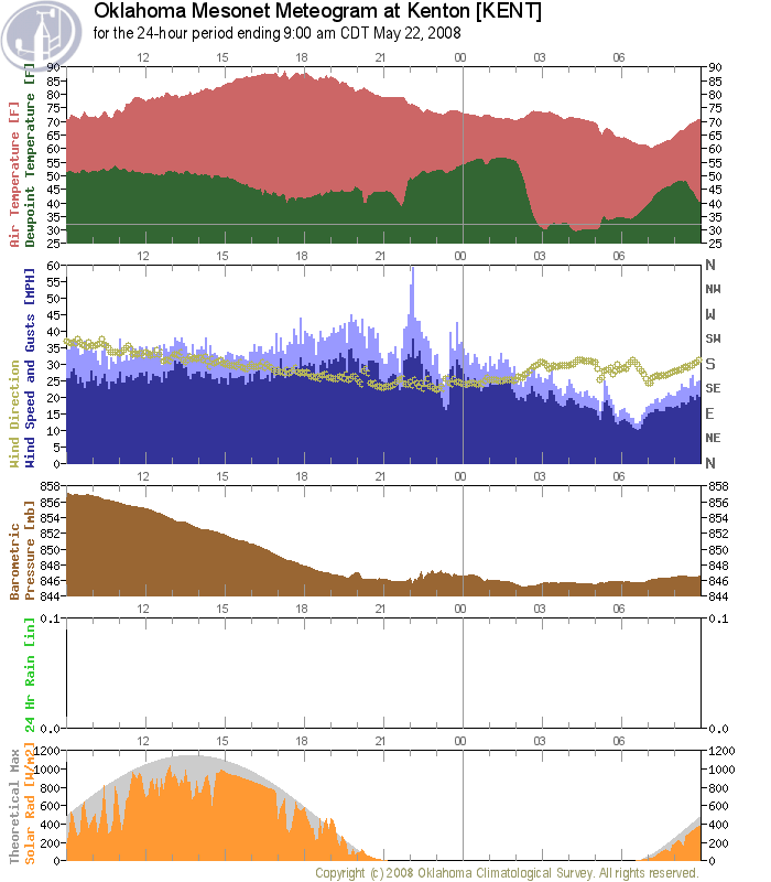
But, here's the problem: the convection was puny and the station
(like all of Cimarron County) got no measurable precipitation.
The precipitation evaporated before it hit the ground. When the
convection passed over the county, it truly passed it over.
That's how it goes when you're mired in a drought; even your severe
weather produces little to no rainfall. The contrast between the dry
panhandle and the rest of the state can be summed up like this: since
April 23rd (30 days), the ironically-named Nowata has received 10.2"
of rain, which is a couple inches more than most of the western
Panhandle observed since April 23rd ... of *2007*.
May 22 in Mesonet History
| Record | Value | Station | Year |
|---|---|---|---|
| Maximum Temperature | 104°F | ALTU | 2000 |
| Minimum Temperature | 32°F | EVAX | 2019 |
| Maximum Rainfall | 3.92 inches | HOLL | 2016 |
Mesonet records begin in 1994.
Search by Date
If you're a bit off, don't worry, because just like horseshoes, “almost” counts on the Ticker website!