Ticker for November 13, 2007
MESONET TICKER ... MESONET TICKER ... MESONET TICKER ... MESONET TICKER ...
November 13, 2007  November 13, 2007  November 13, 2007  November 13, 2007


Wow, What a Day

There's no bitter-coating it: today is profoundly and undeniably
beautiful. It's a great day to inspire you to try something new,
like, say, stealing a convertible.

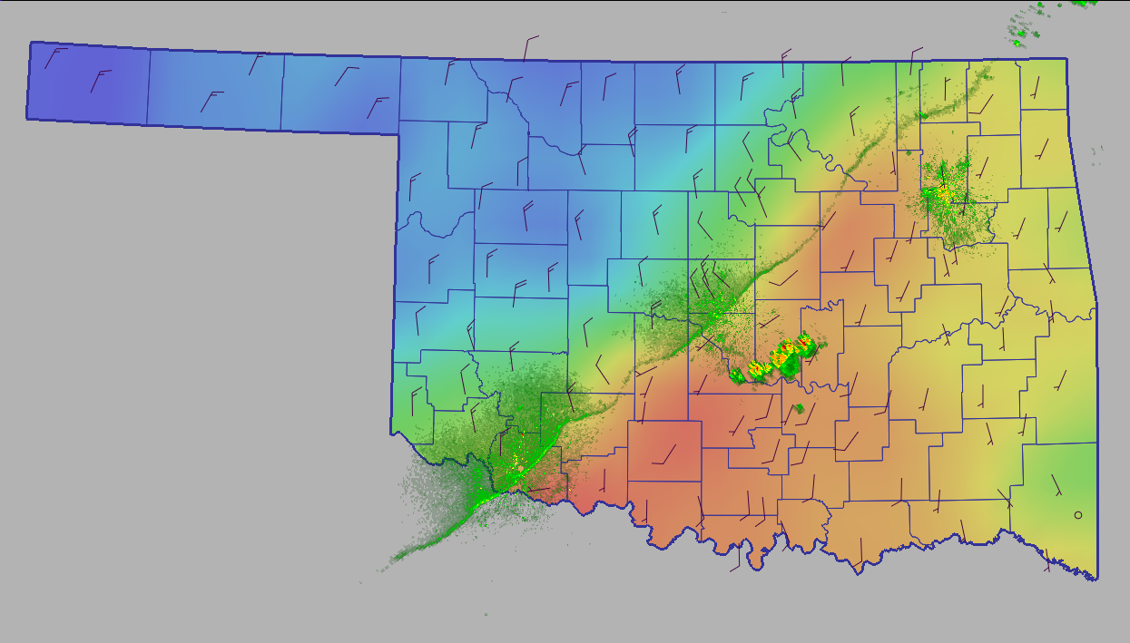
Here's a neat image from yesterday's frontal passage that blew most
of our water molecules back to the south whence they came:


This pic is a snapshot composite of three radars (Tulsa, Okla. City,
Frederick), taken just before sunset yesterday. The front is clearly
visible as a thin line draped from southwest to northeast. Why a thin
line? Well, thin lines on radar often represent boundaries in the
lower part of the atmosphere (like a cold front). Boundaries show up
for a combination of the following reasons:

1. Most importantly, there's a density difference across the
front. The blob of air north of the front is cooler, thus
slightly more dense, than the air mas south of it. This sets
up a refractive effect. For an exaggerated version of this
effect: stick a pencil in a clear glass half-filled with water.
The pencil is "broken" at the boundary between two very different
fluids (air and water).

2. Boundaries often represent locations of focused convergence.
As winds come together, they escort bugs, dust, pollen, etc.
to a common boundary. These particles can help enhance the radar
reflectivity along the boundary.

Also, if you use your imagination, you might be able to detect some
slight deformation of the front in Comanche County. Perhaps it is the
consequence of the Wichita Mountains temporarily slowing up the cool
air's southward drainage? Hard to confirm this, as there are many
processes that can deform surface fronts ... but it's a possibility.

Now, it's time to go enjoy the afternoon ... so, if you have any
questions about today's Ticker, we'll be out in the parking lot, uh,
"testing door handles". If you want to join us, bring a Cowsills CD
and a pair of driving gloves.
November 13 in Mesonet History
| Record | Value | Station | Year |
|---|---|---|---|
| Maximum Temperature | 85°F | ALV2 | 1999 |
| Minimum Temperature | 7°F | EVAX | 2018 |
| Maximum Rainfall | 1.24″ | SULP | 1994 |
Mesonet records begin in 1994.
Search by Date
If you're a bit off, don't worry, because just like horseshoes, “almost” counts on the Ticker website!