Ticker for July 13, 2007
MESONET TICKER ... MESONET TICKER ... MESONET TICKER ... MESONET TICKER ...
July 13, 2007      July 13, 2007      July 13, 2007      July 13, 2007


Temperature Extremes: On the Rise?

During the last month, we've occasionally tried to address the question
"Are Extreme Temperature Events Increasing in Oklahoma?". So far, we
haven't seen much increase in extreme daily temps (on the cold side
or the warm side). In fact, we think we found a general decrease in
extreme-hot events in recent decades (2006 notwithstanding). And, we
saw basically no up or down trend in the frequency of extreme-cold-low
events.

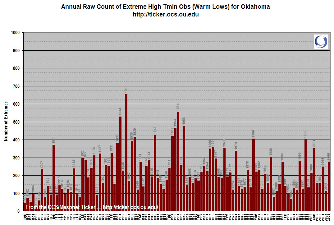
So today, we'll examine the last of the daily temperature indicators:
Extreme warm overnight lows. In other words, which years during the
record have the most "warmest low on record for this date" events?

We'll let the data speak for itself. Speak, data!


Well, data's silence was deafening.

It looks like another no-trend verdict. Honestly, this no-trend
indication was surprising to us, more so than any of the others.

Welp, there you have it, from four angles (highest highs, lowest highs,
lowest lows, highest lows): Are extreme events getting more common in
Oklahoma? The answer, so far, is no.

Keep in mind this is only one way to slice the temperature pie, and
we haven't even begun to look at precip yet. Honestly, we are sick
of rain, and will probably wait.


Speaking of Rain ...

A few days ago, we mentioned that several Mesonet stations had exceeded
their 2006 (and 2005) rainfall totals. That was shocking, but when you
consider how dry those years were, its understandable.

What's creepy is that central and north-central Oklahoma have now
exceeded their AVERAGE annual rainfall. Yep: Central Oklahoma's 37.75"
is three and one-half inches more than the AVERAGE amount it sees in
twelve months. North-Central Oklahoma's 29.38" is a little more than
half an inch more than their annual average.

In other words, if it didn't rain a drop for the next five-and-a-half
months, 2007 would go down as a "wet year" in these regions.
July 13 in Mesonet History
| Record | Value | Station | Year |
|---|---|---|---|
| Maximum Temperature | 109°F | LAHO | 2003 |
| Minimum Temperature | 52°F | BOIS | 2008 |
| Maximum Rainfall | 4.29″ | CLAY | 2025 |
Mesonet records begin in 1994.
Search by Date
If you're a bit off, don't worry, because just like horseshoes, “almost” counts on the Ticker website!