Ticker for February 28, 2006
MESONET TICKER ... MESONET TICKER ... MESONET TICKER ... MESONET TICKER ...
February 28, 2006 February 28, 2006 February 28, 2006 February 28, 2006
Drought Update
The latest - and very dry - drought statistics are now available from
OCS's Climate Information Group. They are available here:
https://content.mesonet.org/ticker/archive/20060228/drought.20060228.pdf
Some highlights (lowlights):
The current season is the driest such season (ending Feb 27) on
record for each of Oklahoma's nine climate divisions, on at least
one time scale (30, 60, 90, 120, 180, 365 days)
It has now been 140+ days since a day saw more than a quarter-inch
of precip for much of southwest Oklahoma
For extreme southwest Oklahoma, it's been 140 days since a tenth-inch
fell on one calendar day.
Chilling Hours
The Mesonet's two-campus leadership makes us all smarter. One thing
that the Ticker Staff would have never known if not for the Mesonet's
ecumenical nature: crisp winter days and nights can make for more
productive orchards, even before we see blooms!
In fact, one measure the quality (and quantity) of a fruit tree's early
spring growth, and its subsequent fruitset, is the number of chilling
hours it experiences during its over-winter season. Inadequate chilling
may lead to smaller and fewer fruits! For fruit aficionados -- and you
know who you are -- here's the running total since the beginning of
"chill season":

And here's how the latest seven days have panned out, through yesterday:
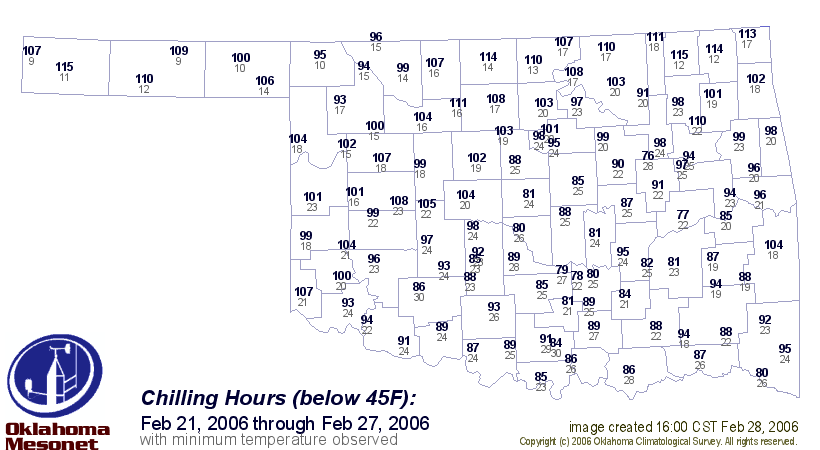
Thanks to Al Sutherland, OSU's Mesonet Agricultural Coordinator, for
prompting this useful product!
February 28 in Mesonet History
| Record | Value | Station | Year |
|---|---|---|---|
| Maximum Temperature | 90°F | HOLL | 2006 |
| Minimum Temperature | 7°F | BEAV | 2019 |
| Maximum Rainfall | 3.70 inches | BROK | 2018 |
Mesonet records begin in 1994.
Search by Date
If you're a bit off, don't worry, because just like horseshoes, “almost” counts on the Ticker website!