Ticker for February 19, 2006
MESONET TICKER ... MESONET TICKER ... MESONET TICKER ... MESONET TICKER ...
February 19, 2006 February 19, 2006 February 19, 2006 February 19, 2006
A Different Slant on Snow
In the last 48 hours our parched stat has seen two "wintry mix"
precip episodes that brought headaches and heartaches with their
very welcome output. Is it much in the drought's big picture?
No. But maybe it's a start.
Anyway, we got to see some very interesting snow patterns on both
weekend days. Let's take a look at some of what went down on radar
early Saturday afternoon. Here's an image from 12:42 pm that overlays
Tulsa radar on top of OKC radar.
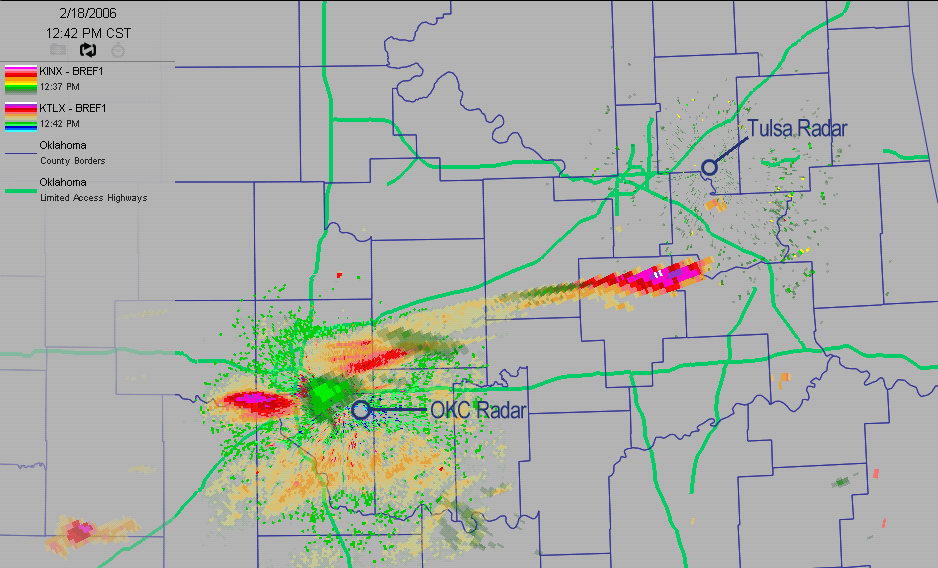
A couple of things to point out. The greenish images of precipitation
are from the Tulsa radar. The pink and orange returns are from the
Oklahoma City radar. The reason the colors are different is because
they operating in different modes: a precip mode at Tulsa and a
"clear air" mode at OKC. There are relative advantages to each, but
all that matters to us is that the difference in the modes helps us
see which returns are from OKC and which are from Tulsa.
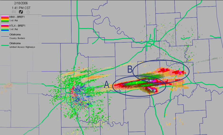
Anyway, notice that there are three pairs of echoes on the images:
two pairs very near the OKC radar, and a third pair just southwest
of the Tulsa unit. If one were to circle the pairs, one might circle
them thusly:
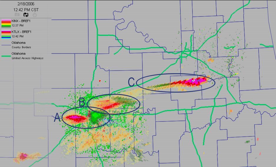
Notice that in Group A and Group B, the Tulsa echoes are eastward of
the OKC echoes. On Group C, the OKC echoes are east of Tulsa's!
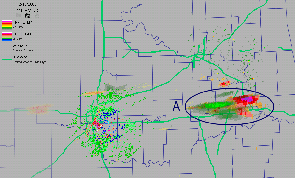
Let's fast-forward 20 minutes to 1:02 pm. All three pairs have scooted
eastward, and the Group A and Group C echoes have grown even farther
apart. The echoes on Group B have become closer.
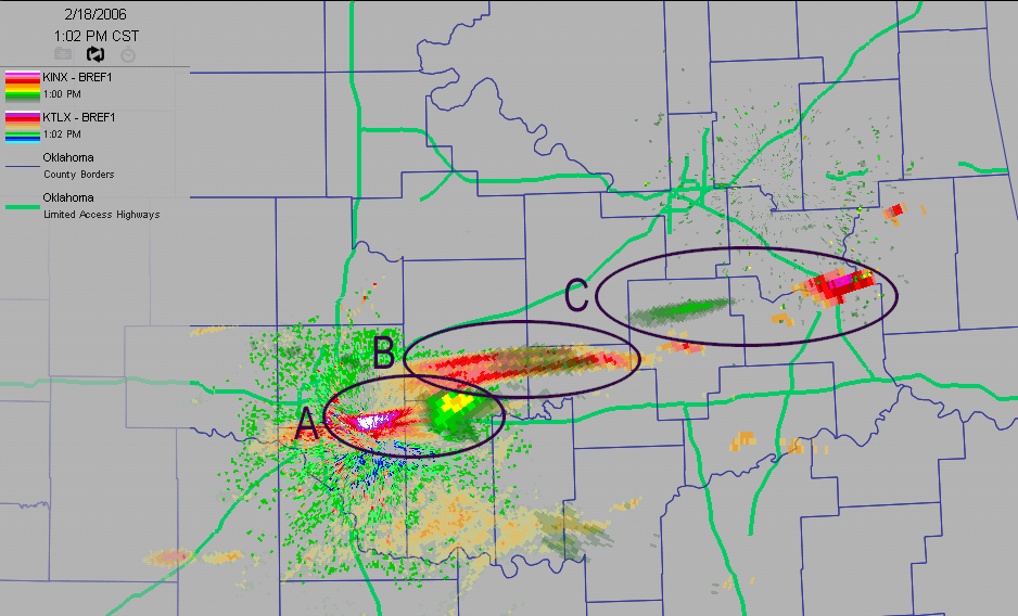
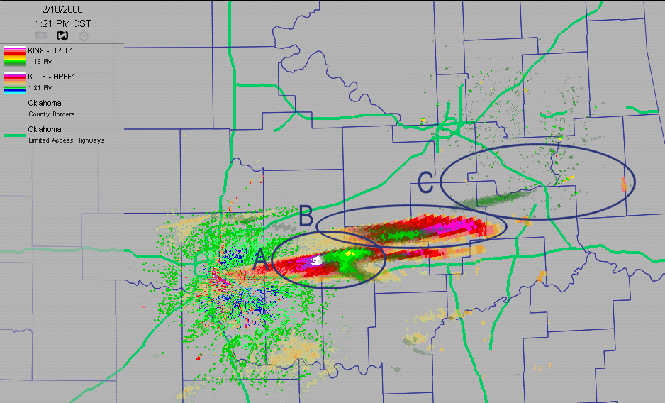
In fact, go ahead and watch the whole thing unfold. Play close attention
to how the OKC echoes in Group A catch up and pass the Tulsa echoes
from Group A:
Well, that's weird. What's happening?
A bunch of stuff.
Part One: First of all, Saturday was a great day for slantwise
convection. Slantwise convection is, well, convection that slants.
It's related to a concept named "Conditional Symmetric Instability",
which we promise to never say again, ever. CSI happens in certain
situations with a number of factors (we'll spare the details), but
they were all present on Saturday.
The bottom line is this: the convective elements that made heavy snow
were tilted over, dramatically. They were generally tilted to the east.
In other words, their bottoms sat to the west of their tops. How can
we know this? That leads us into part two of the explanation.
Part Two: One of the ugly secrets of radar beams is that they get
higher off the ground as they go. It's inevitable. For one thing, the
beams are tilted. For another, the earth is round. These two factors
mean that close to the radar, we're looking lower than we are far
from the radar.
Or, thinking about it another way: very near the OKC radar, the Tulsa
radar is looking much, much higher in the atmosphere than the OKC radar.
Does that make sense? So, when a little piece of slanted convection sits
near the OKC radar, the OKC radar will see the lower, more westward
bottom, while the Tulsa radar will see it's higher-up, more-eastward
top! In other words, this will happen:
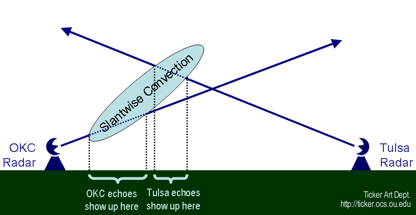
And that's exactly what we saw in Groups A and B in the early frames.
Notice on Frame 4 that the OKC Group A elements caught up to the Tulsa
Group A elements. And notice where it happened: at about Okemah, which
is roughly an equal distance from the two radars. So, the two radars
sample the atmosphere at roughly the same height over Okemah! By frame
five, when the Group A elements made it all the way over to Muskogee,
they were much nearer the Tulsa radar. As a result, the OKC radar saw
the higher, more-eastward precip!
We hope you've enjoyed our slant on slantwise convection. For the true
blue weather fans out there, here's the Norman sounding on that day,
you can see the factors that help set up CSI and slantwise convection:
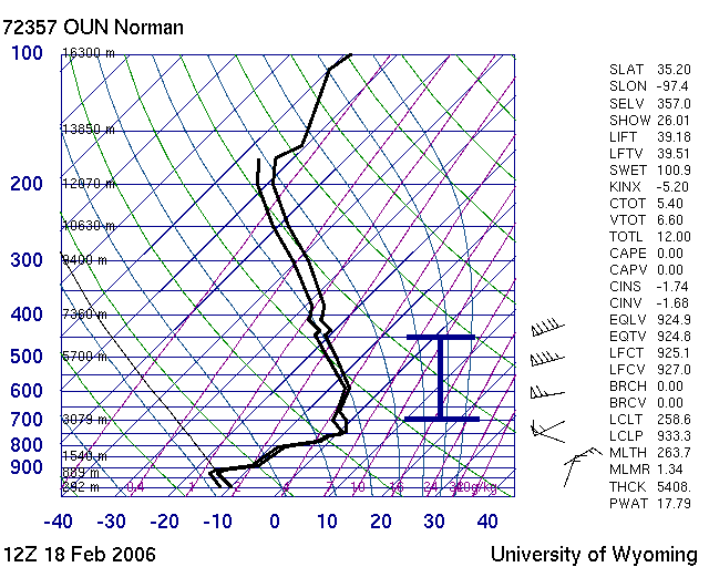
(WARNING: graphic content, if you don't like graphs, don't look)
Notice on the little area above about 700mb:
a near-moist-adiabatic temperature trace
a near-saturated sounding
a rapid increase in winds with height (from near zero to 90 knots)
Very cool forensic stuff for CSI fans!
February 19 in Mesonet History
| Record | Value | Station | Year |
|---|---|---|---|
| Maximum Temperature | 81°F | ALTU | 2004 |
| Minimum Temperature | -8°F | CHIC | 2021 |
| Maximum Rainfall | 2.94 inches | BURN | 1997 |
Mesonet records begin in 1994.
Search by Date
If you're a bit off, don't worry, because just like horseshoes, “almost” counts on the Ticker website!