Ticker for February 13, 2006
MESONET TICKER ... MESONET TICKER ... MESONET TICKER ... MESONET TICKER ...
February 13, 2006 February 13, 2006 February 13, 2006 February 13, 2006
Westerly Winds Warm Waking West in Their Wake
If you've been reading the Ticker for a while, you'll know of our
fondness for inversion poking and our undying loyalty to meteograms
as one of the best learning tools out there. Today, we combine our
fondness and undying loyalty into one tale.
This morning featured a very shallow, very stable layer of cold air
hugging the surface. And screwy things happen in Mesonet data when
that arrangement is, uh, arranged. Take a look at a morning snapshot:
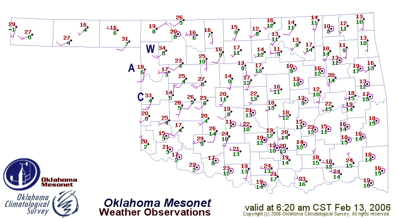
Chilly temps, ranging from 15 to 25, dominate the state. Well, except
for the very conspicious exceptions of Cheyenne (33F - marked with a
"C" for your convenience) and Woodward (34F - "W").
Notice the winds on this map. The wind field across most of Oklahoma
is a near-calm medley of incoherence. At the two warm stations, they
are breezy - much breezier than the generally calm conditions
elsewhere. There's something to that.
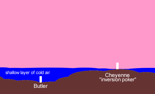
The Cheyenne and Woodward sites are both set upon subtle ridges ...
literal, actual, tangible ridges made of earth and rock - not the
ephemeral atmospheric ridges of the meterologist's lexicon. This
superior setting helps such stations "poke through" shallow inversions
when conditions are right, which can elicit substantial differences
from neighboring stations. These difference are usually a stronger and
more coherent wind pattern and generally warmer conditions. This
morning, it accounted for this morning's 20-degree swing between
Cheyenne and Arnett ("A") just to its north.
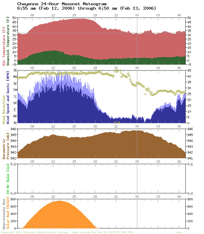
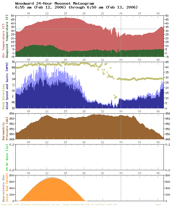
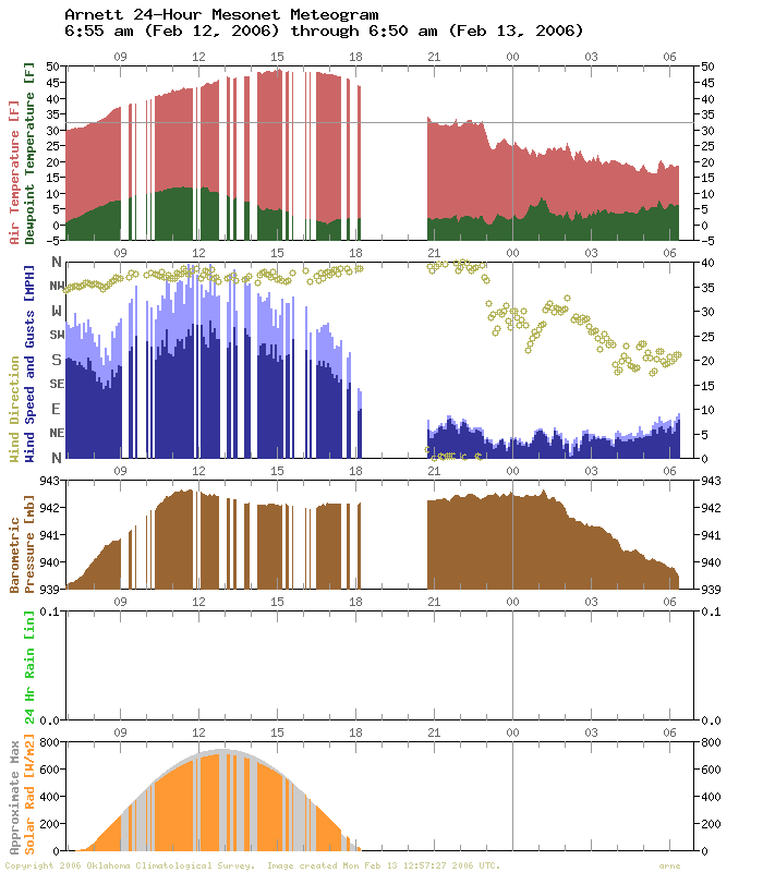
Notice the consistency and strength of the winds in the Cheyenne and
Woodward meteograms, compared to Arnett:
The general process was artfully depicted (okay, it was depicted) in
the November 20, 2001 version of the Ticker:
Meteograms are Really Neat, Part 891
Hey, take a look at that Arnett meteogram again:
Notice that big chunk of missing data on the right/recent side of the
graph? Well, it's no coincidence that we'd see such a pattern on a
day when we talk about inversion pokers. Inversions play havoc with
wireless communications, which any amateur radio operator can tell
you (and any central-Oklahoma kid who tried to pick up Royals games
broadcast from Coffeyville, KS in the 1970s, but that's not important
right now).
Anyway, while Cheyenne and Woodward were poking through inversions and
providing interesting things to talk about, poor Arnett was mired in
a shallow layer of very cold air, which bends radio waves in ways that
are frustrating (it's like a mirage, but in reverse).
Meteograms are Really Neat, Part 892
We mentioned that screwy and interesting things happen with shallow
stable layers. Check out the meteogram from Spencer:
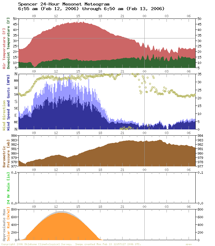
That regular oscillation in the temperature may be a surface
reflection of waves travelling across our shallow, stable layer. You
can see similar patterns across much of central Oklahoma this morning.
February 13 in Mesonet History
| Record | Value | Station | Year |
|---|---|---|---|
| Maximum Temperature | 79°F | KENT | 2016 |
| Minimum Temperature | -8°F | EVAX | 2025 |
| Maximum Rainfall | 2.32 inches | BBOW | 2001 |
Mesonet records begin in 1994.
Search by Date
If you're a bit off, don't worry, because just like horseshoes, “almost” counts on the Ticker website!