Ticker for January 7, 2006
MESONET TICKER ... MESONET TICKER ... MESONET TICKER ... MESONET TICKER ...
January 7, 2006 January 7, 2006 January 7, 2006 January 7, 2006
The Power of Subtle Influence
The course of humanity is riddled with testimony to the power of
subtle influence. In biography, story or fable, a slight nudge
can cause profound change, if conditions are right. A kind
compliment, or an uncaring cold shoulder, here or there, can shape
developments that change the course of history.
Well, the influnces of breeze on overnight lows aren't quite so
theatric, but they can be dramatic, even profound. For example,
here's a snapshot of Friday night's weather conditions across
Oklahoma:
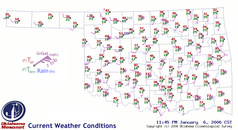
It's no coincidence that the highest temperature on the map (53 F
at Fairview) is co-located with the strongest winds (20 mph, gusting
to 25 mph). Every station with sustained winds of 15 mph or more
has a temperature in the upper 40s.
On the flip side, almost all of the calm-wind locations are quite
chilly. Camargo's near-zero wind delivered a temperature of 32 F,
while its windy neighbors at Woodward and Cheyenne reported 48 F
and 49 F, respectively. Chickasha's 28 F stands in stark contrast
to the 49 F to the south at Acme, and 42 F to the north at Minco.
And notice the temps in the calm southeast - it's the coldest region
on the map, with all stations buried in the 20s, save for the 38 F
at oh-so-slightly-breezy Clayton.
So what's happening? How can unimpressive winds summon forth such
impressive results? Just like the story of humanity, conditions have
to be just right.
On clear, dry nights, the Earth's radiative cooling can occur with
very little obstruction (think of how much farther you can see in
clear, dry conditions). As this cooling goes on unabated, temps
near the surface can fall dramatically. This can set up a very, very
shallow layer of much cooler air. Very, very shallow layers tend
to be very, very fragile to disturbance by wind.
Think of a dusting of flour on a table top. As long as no wind blows,
it's safe. But puff of wind - however slight - will disturb this
layer, mixing it up into the air above it. The thin layer that was
once dominated by flour (or cold air in our real world example) is
replaced by a mixture that is dominated by the characteristics of
the air above.
The cooling is still occurring at the windier sites, it's just that
the wind doesn't allow the impact of the cooling to be concentrated
at the surface.
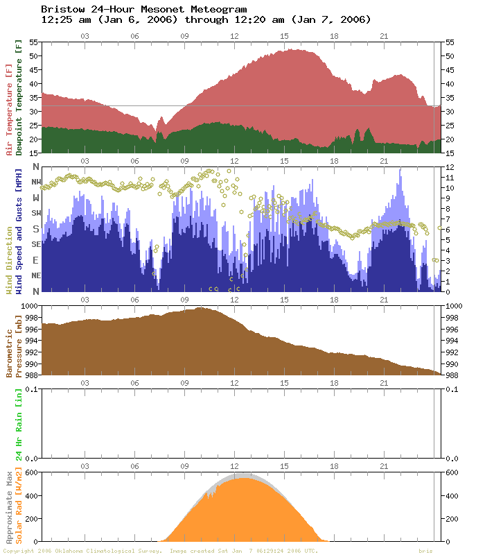
Meteograms show this process at work, one site at a time. We've saved
two, one from Bristow and one from Cherokee. In each, after 6:00 pm,
periods of stronger winds are associated with higher temps:

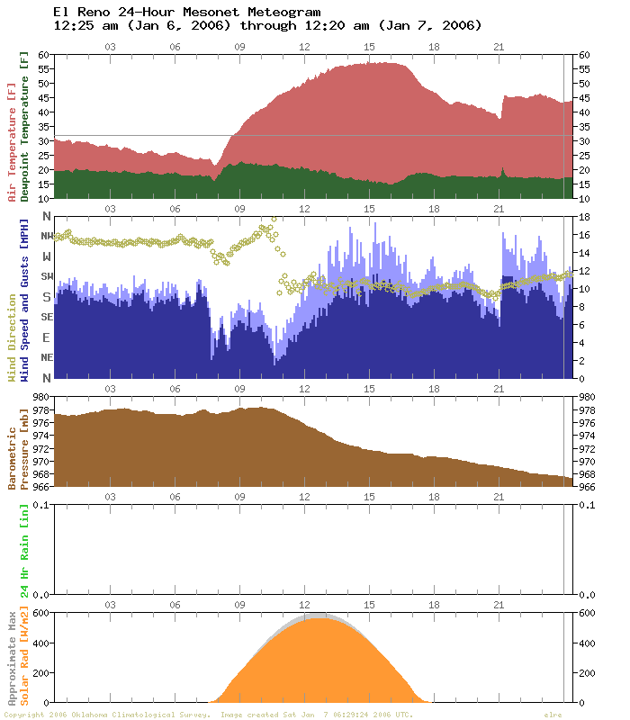
Finally, just for fun, we've thrown in the meteogram from El Reno,
a site which is rather notorious for its propensity to cool more
rapidly than its neighbors (This is due largely to the processes
described above, and some of OCS's student employees did some neat work
on this El Reno phenomenon!).
Tonight, anyway, something excited the wind field around 9:00 pm,
and temps held high through midnight:
January 7 in Mesonet History
| Record | Value | Station | Year |
|---|---|---|---|
| Maximum Temperature | 85°F | WOOD | 2006 |
| Minimum Temperature | -19°F | KENT | 2017 |
| Maximum Rainfall | 2.75 inches | PORT | 2008 |
Mesonet records begin in 1994.
Search by Date
If you're a bit off, don't worry, because just like horseshoes, “almost” counts on the Ticker website!