Ticker for October 24, 2005
MESONET TICKER ... MESONET TICKER ... MESONET TICKER ... MESONET TICKER ...
October 24, 2005   October 24, 2005   October 24, 2005   October 24, 2005


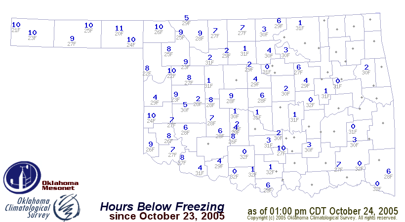
Updated Frost/Freeze Information

Please forgive the re-send, but several Ticker recipients asked for an
assessment of this morning's freeze.

The following map shows the number of hours below freezing (blue), and
the lowest temperature observed (gray).


Southeast Oklahoma: Last 180 Days Driest on Record

As of Sunday morning, the previous half-year was the driest such period
of the modern record for the southeast Oklahoma climate division.
The area-averaged rainfall of 12.84" is less than half the normal value.
The previous dry-water mark for the preceding 84 periods (all Apr 26
through Oct 22) was 13.10", set in 1956.

The rest of eastern Oklahoma is quite dry over the period as well.

More detail can be found at the Oklahoma Climatological Survey's Drought
Update page:

http://climate.mesonet.org/rainfall_update.html

The 180-day tab can be found at:

http://climate.mesonet.org/drought/180days.php
October 24 in Mesonet History
| Record | Value | Station | Year |
|---|---|---|---|
| Maximum Temperature | 96°F | GRA2 | 2003 |
| Minimum Temperature | 20°F | BEAV | 2005 |
| Maximum Rainfall | 6.72″ | MCAL | 2019 |
Mesonet records begin in 1994.
Search by Date
If you're a bit off, don't worry, because just like horseshoes, “almost” counts on the Ticker website!