Ticker for August 29, 2005
MESONET TICKER ... MESONET TICKER ... MESONET TICKER ... MESONET TICKER ...
August 29, 2005    August 29, 2005    August 29, 2005    August 29, 2005


Absence Makes the Heart Grow Fonder, or something like that

It's good to be back from a punishing schedule of OK-FIRST workshops,
Emergency Management Conferences, out-of-town engagements, and whatnot.
But summer playtime is over, and the Ticker Staff will now return to
its regular (?) schedule.


Absence Makes the Drought Grow Stronger, or something like that

This August has been extraordinarily wet across most of the state.
In fact, it appears that west-central and central Oklahoma may just
break some monthly precipitation records. Early data from the Oklahoma
Mesonet indicate the wettest month-in-progress on record (since 1921,
in this case):

https://content.mesonet.org/ticker/archive/20050829/aug05.html

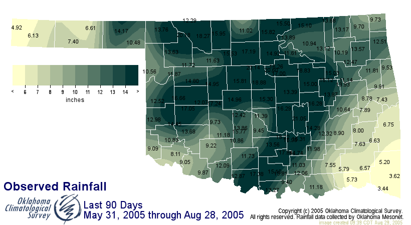
Some very notable exceptions to the wet rule are southeast Oklahoma,
and other parts in far eastern Oklahoma. The demarcation between
unseasonably wet and unbearably dry is quite distinct, as seen on this
map of rainfall for the last 90 days:


In fact, take a look at the rainfall totals in McCurtain County and
Cimarron County.  Kenton has received more rainfall in the last three
months than Idabel and Broken Bow!
August 29 in Mesonet History
| Record | Value | Station | Year |
|---|---|---|---|
| Maximum Temperature | 109°F | WAUR | 2011 |
| Minimum Temperature | 48°F | EVAX | 2017 |
| Maximum Rainfall | 5.06″ | VINI | 2003 |
Mesonet records begin in 1994.
Search by Date
If you're a bit off, don't worry, because just like horseshoes, “almost” counts on the Ticker website!