Ticker for April 25, 2005
MESONET TICKER ... MESONET TICKER ... MESONET TICKER ... MESONET TICKER ...
April 25, 2005 April 25, 2005 April 25, 2005 April 25, 2005
How to Get an "A" in Meteorology (without really trying)
There are several "A" words one might use to describe the Mesonet:
accurate, admirable, always-on, or (for the 80s fan) "Awesome!".
Well, the Mesonet stations whose names begin with "A" teamed up
to teach a bushel full of nifty meteorological principles today.
Here are their tales and teachings:
Altus and Ardmore: Wet-bulbing Isn't Just for Winter Events
Take a quick look at the Altus and Ardmore meteograms:
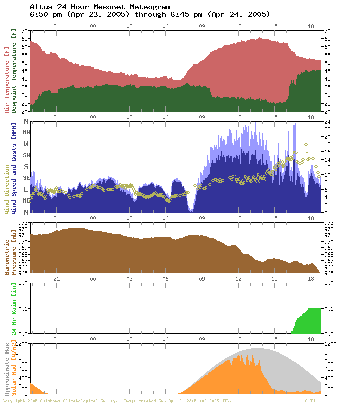
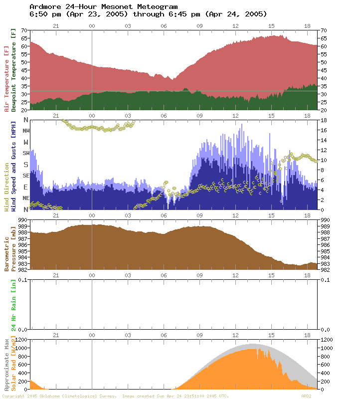
You'll notice that the two stations behaved much like each other
throughout the day. They both show show similar pressure traces.
They both show increasing cloud cover on the afternoon of the
24th. They show similar wind speed patterns, and their temperature
traces are very closely related.
Until about 4:00 pm, that is.
Check out how the Altus temperature and dewpoint temperature come
crashing together around 4:00 pm. Ardmore's meteogram has no such
feature. That's when approaching precipitation fell into the dry
air at Altus.
3:30pm - 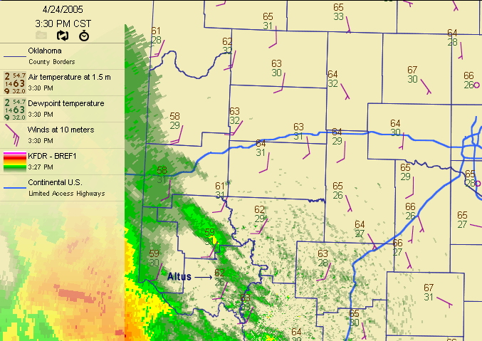
4:30pm - 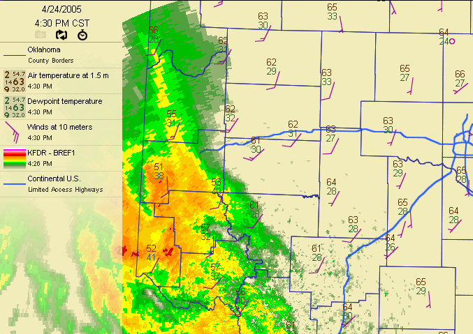
5:30pm - 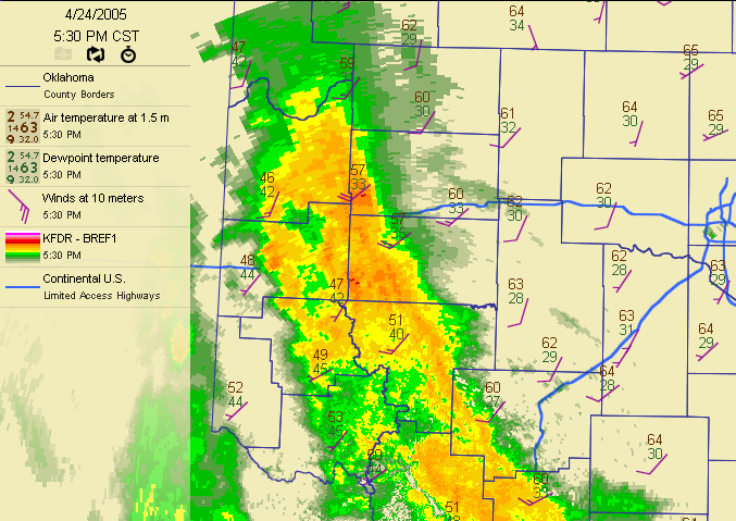
Some of the precip evaporated, of course, which both cools the
air and adds moisture to it. Because of this, temp/dewpoint at
Altus went from 62/26 at 3:30 to 53/45 just two hours later.
This converging of air temperature and dewpoint temperature is
called "wet-bulbing", because if the process goes on long enough,
these two values would meet at the wet-bulb temperature.
Arnett: Wet-bulbing Isn't Just for Measurable Precipitation
Not to be outdone by its pedagogic A-list cousins, Arnett showed
that wet-bulbing can even happen when the rain doesn't make it
to the ground. Take a look at its meteogram:
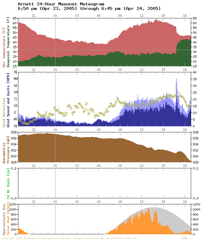
It looks a lot like the wet-bulbing signature at Altus, with two
notable exceptions: a very healthy wind gust and zero rainfall.
The wet-bulbing (and the wind gust) was caused by the same
process in play at Altus: precip falling into dry air. However,
the rain at Arnett was much lighter, so it evaporated before
reaching the ground. You can see the sequence of events in the
following three slides:
3:30pm - 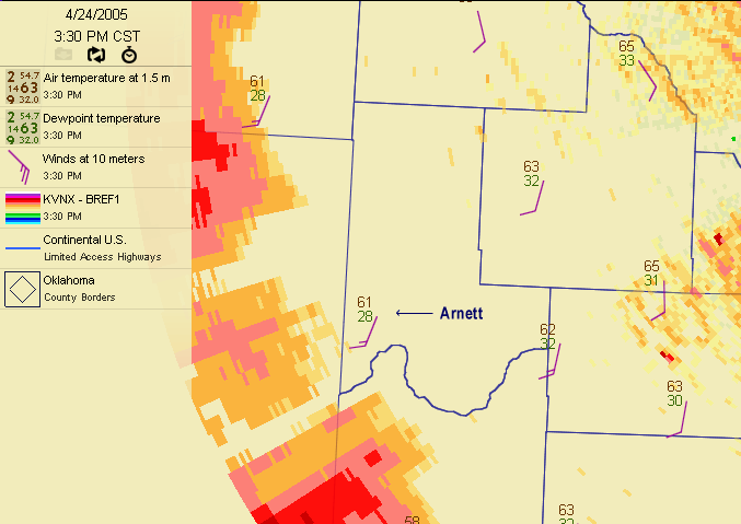
4:30pm - 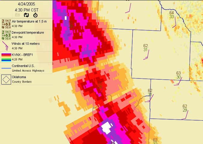
5:30pm - 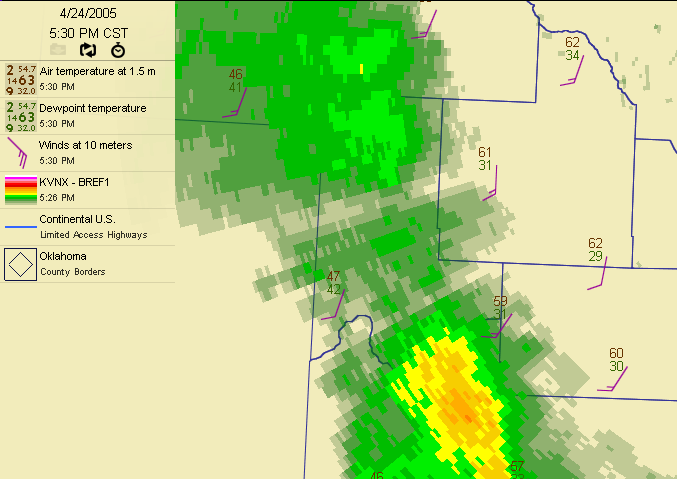
At 3:30, Arnett was sitting at an arid 61/28 temp/dewpoint combo,
with approaching precip to the west. The precip was so light that
the radar hadn't switched over to "precip mode", which explains
the screwy color palette. An hour later, the very light rain had
almost arrived, with little change in Arnett's temperature and no
change in dewpoint. By 5:30, the line had passed (and the radar
had switched to precip mode) and Arnett's temp and dewpoint had
come together in the mid-40s, while the rain gauge hadn't recorded
a drop!
Acme: The Significant Influence of Insignificant Overnight Winds
The Acme meteogram illustrates a topic from the last Ticker: how
wind, almost any wind, can help keep overnight temps up on clear
nights. But before we dive into the data, let's talk a bit about
inversions.
Simply put, inversions are a layer of relatively warm air in the
atmosphere ("relatively" being a key word). When that relatively
warm layer is just above the surface, we call it a surface inversion.
These often form on calm, clear nights, as the earth radiates away
much of its daytime heating. The air very near the surface cools
rapidly, which makes it heavier, so it stays near the earth in
a shallow, cool layer - as shallow as tens of feet.
Now, as long as something doesn't come and stir up this heavier air,
it's quite happy near the surface, thankyouverymuch. But when a bit
of wind fires up, it can destroy this delicate pool of cold air and
mix in some of the warm air from just above. This is exactly what
happened at Acme about 4 o'clock Sunday morning, when the winds
picked up to about 6 mph:
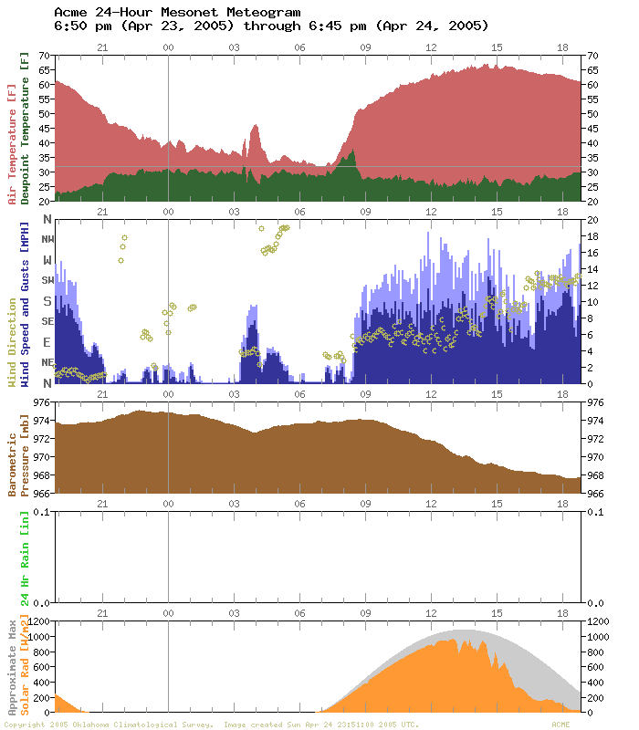
Now, that hiccup in the air temperature trace may not seem big, but
check the scale. A little bit of wind bumped it from 35 to 45!
Moreover, every little bit counts in the early spring when you're
concerned with freezing temps.
So, the next time you're camping with your buddies on a calm, cold
night, tell them you wish a breeze would come along and warm things
up a bit!
(Okay, that'll never happen. Save the camping trip, and just impress
your buddies with your inversion/wind knowledge next time you see
them.)
Antlers: Breathing Water Into the Surface Layer
The first three lessons from our A-list Mesonet stations were
interesting, but Antlers wins the blue ribbon if you're a hardcore
fan of micro-meteorology (and, let's face it, who isn't?).
One thing we didn't explicitly mention about inversions: they
prohibit vertical mixing. In other words, it's almost as if they
are a giant blanket which traps particles and other stuff near
the surface. Under strong inversions, pollutants like smoke, ozone
and smog hang around near the ground in much larger concentrations,
because they are "capped" by this blanketing inversion. Ever wonder
why flowers or honeysuckle - or even your lawn - seem more fragrant
on a calm morning, right around sunrise? Try it, you'll agree!
(you can also try this with the water treatment plant or compost
facility - yecch).
Well, in this sense, water molecules are no different than smoke
particles or heavenly floral aromas. They get trapped and can
concentrate under inversions.
Check out the Antlers meteogram during the morning of the 24th:
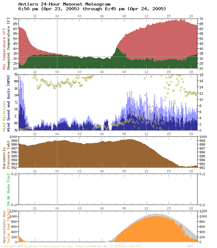
See that dramatic spike in temperature *and* dewpoint just after
sunrise? First of all, Antlers was one of the coolest sites in
the state at that time, so there was surely a strong inversion
at the site. That strong inversion took some time to "bake off"
in the early daylight hours. In the meantime, morning dew/frost
began to evaporate/sublimate in the early morning sun. Plants
continued to breathe water into the air, like plants do. But all
of those water molecules had no place to go, trapped under the
blanketing surface inversion.
With nowhere to go, especially not up, these water molecules
stayed near the surface just like smoke or smog. The result? The
dewpoint rose rapidly with the air temperature after sunrise.
At about 8:00 am, the inversion finally mixed out, and all of the
near-surface water molecules were free to run around in a much
deeper layer of the atmosphere. As those water molecules mixed
upward toward their destiny, the surface dewpoint slipped down
to its overnight baseline of about 30 degrees.
We hope you enjoyed these meteorology lessons from the Oklahoma
Mesonet's "A List" stations. Go out and get an "A" today!
April 25 in Mesonet History
| Record | Value | Station | Year |
|---|---|---|---|
| Maximum Temperature | 105°F | ERIC | 2012 |
| Minimum Temperature | 28°F | BURN | 2013 |
| Maximum Rainfall | 4.84 inches | MEDF | 2009 |
Mesonet records begin in 1994.
Search by Date
If you're a bit off, don't worry, because just like horseshoes, “almost” counts on the Ticker website!