Ticker for November 23, 2004
MESONET TICKER ... MESONET TICKER ... MESONET TICKER ... MESONET TICKER ...
November 23, 2004 November 23, 2004 November 23, 2004 November 23, 2004
Soggy November Will Re-Write Some Record Books in Southwest Oklahoma
A quick look at the following graphics tells quite a tale:
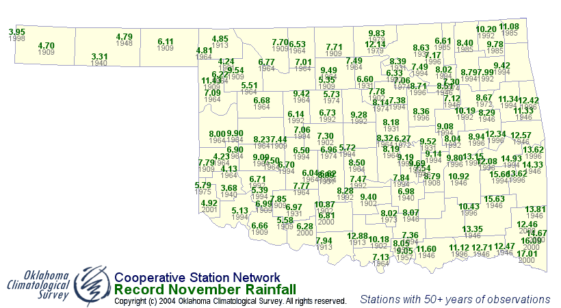
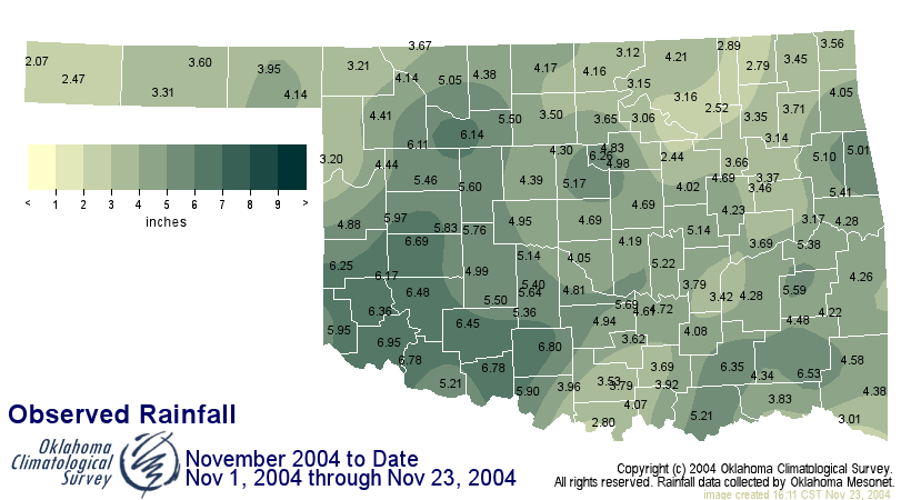
The former map shows the existing record maximum November rainfall
for NWS Cooperative stations with 50+ year service history. The
latter shows month-to-date Mesonet rainfall totals. Now, these are
two different networks with different locations and methods. But,
throwing aside some scientific rigor, it's pretty clear that
rainfall records will tumble - or have already tumbled - this
month in southwest Oklahoma.
And Now, The Rest of the Story ...
Take a closer look at the first graphic - the one with the records.
Notice the years in which those records were set? There are an
awful lot of 1990s and 2000 records running around in that map!
In fact, more than a third of the records came in the 1991-2000
years, which goes a long way toward explaining the large jump in
"normal" November rainfall earlier this decade.
Of the twelve months on the calendar, November might be the one
which is evolving the most rapidly, and the recent trend of
high-end wet Novembers continues in 2004. The most intriguing
question: "why?" remains to be answered.
November 23 in Mesonet History
| Record | Value | Station | Year |
|---|---|---|---|
| Maximum Temperature | 81°F | IDAB | 2010 |
| Minimum Temperature | 8°F | KENT | 2003 |
| Maximum Rainfall | 3.85 inches | BBOW | 2000 |
Mesonet records begin in 1994.
Search by Date
If you're a bit off, don't worry, because just like horseshoes, “almost” counts on the Ticker website!