Ticker for July 16, 2004
MESONET TICKER ... MESONET TICKER ... MESONET TICKER ... MESONET TICKER ...
July 16, 2004 July 16, 2004 July 16, 2004 July 16, 2004
Frederick Radar Goes Batty!
Mesonet Operator Cindy Morgan tipped us off to a very cool radar
phenomenon that occurred during last night's dusky hours.
As a surface boundary retreated across southwest Oklahoma toward
the setting sun, the Frederick radar picked it up quite nicely:
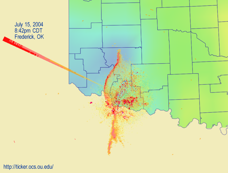
The boundary is the serpentine curve that lays atop Kiowa and eastern
Jackson Counties and into Texas. Notice that it is west of the radar,
which is important to the later discussion.
But first, an aside: do you see the spike that shoots west-northwest
out of the radar? That is the setting sun! Radars shoot pulses of
microwaves, then go into a "waiting" mode, when they essentially
become microwave-sensitive eyeballs. The sun, being celestial and
all, emits a great deal more microwave raditation than the radar
is tuned to emit and subsequently observe. As a result, the radar
is "blinded" by the overwhelming microwave signal when it looks
into the sun ... just like we are when we turn our visible-light
detectors toward the Sun.
Okay, okay. Back to our boundary. That boundary represents a density
difference between two air masses. This difference can cause some
refraction or "bending" of the radar's microwaves (a phenomenon you can
observe if you hold a pencil halfway into an aquarium). The result for
our radar is that it may see things closer to the ground than it
typically would.
Well, the radar did see something at 9:12 pm:
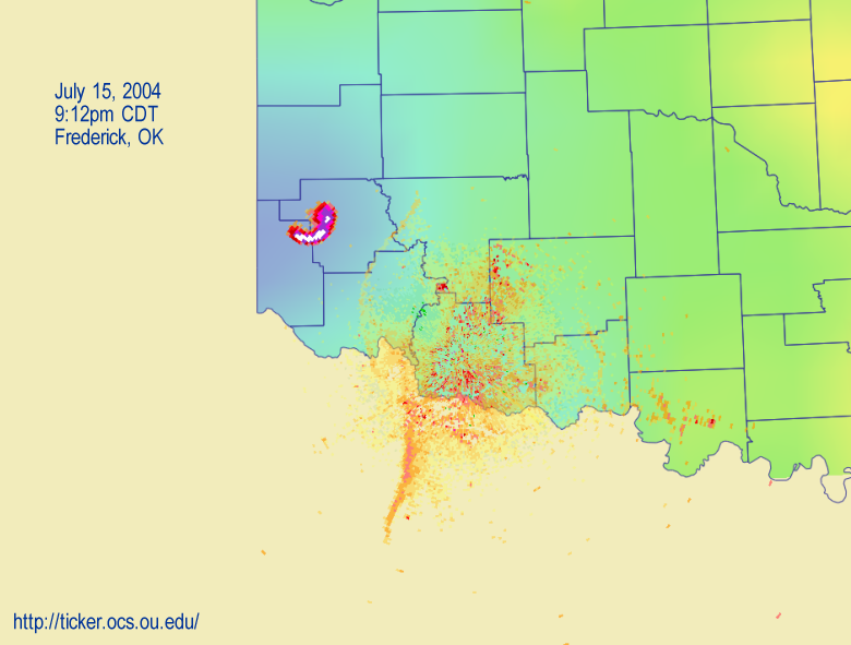
See that bright arc northwest of the radar, straddling the Greer-Harmon
County line? Twenty minutes later, the arc had expanded and a second
arc had emerged in its original location:
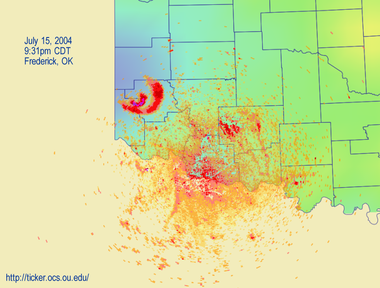
By 9:50 pm the feature had grown to the size of Greer County!

What was it?
In all likelihood, the radar picked up several squadrons of bats!
These squadrons appeared as successive rings, as they emerged from
their daytime shelter on their nocturnal flight for some tasty Greer
County bugs!
July 16 in Mesonet History
| Record | Value | Station | Year |
|---|---|---|---|
| Maximum Temperature | 109°F | HOLL | 2001 |
| Minimum Temperature | 51°F | JAYX | 2014 |
| Maximum Rainfall | 3.82 inches | ALTU | 2014 |
Mesonet records begin in 1994.
Search by Date
If you're a bit off, don't worry, because just like horseshoes, “almost” counts on the Ticker website!